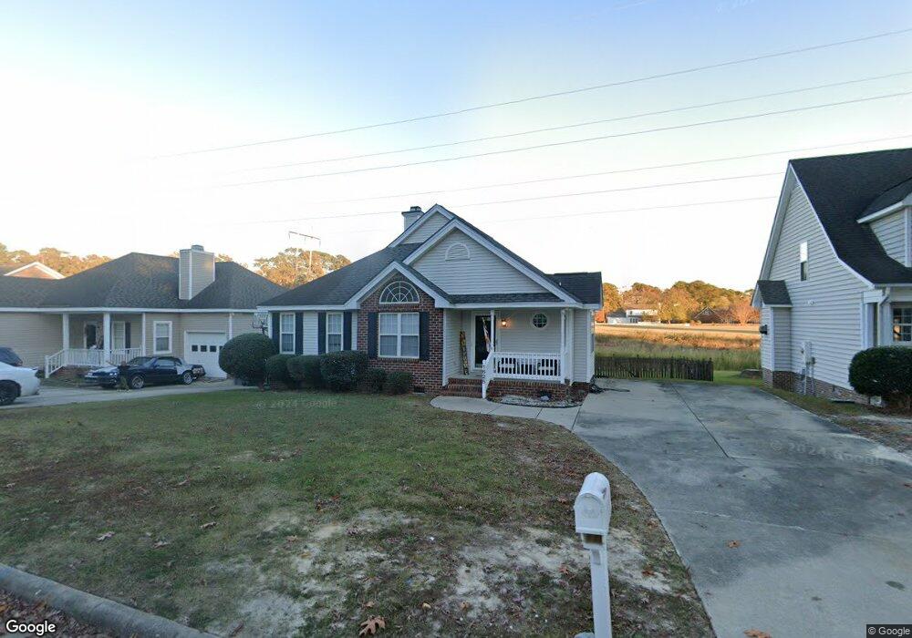
1625 Shamrock Ln Rocky Mount, NC 27804
Estimated Value: $191,684 - $230,000
3
Beds
2
Baths
1,438
Sq Ft
$150/Sq Ft
Est. Value
About This Home
This home is located at 1625 Shamrock Ln, Rocky Mount, NC 27804 and is currently estimated at $215,671, approximately $149 per square foot. 1625 Shamrock Ln is a home located in Nash County with nearby schools including Northern Nash High School, M.B. Hubbard Elementary School, and Red Oak Middle School.
Ownership History
Date
Name
Owned For
Owner Type
Purchase Details
Closed on
Nov 17, 2008
Sold by
Scalera Wesley M and Scalera Angela M
Bought by
Thompson Kevin and Thompson Lauren
Current Estimated Value
Home Financials for this Owner
Home Financials are based on the most recent Mortgage that was taken out on this home.
Original Mortgage
$121,299
Outstanding Balance
$80,970
Interest Rate
6.51%
Mortgage Type
FHA
Estimated Equity
$134,701
Create a Home Valuation Report for This Property
The Home Valuation Report is an in-depth analysis detailing your home's value as well as a comparison with similar homes in the area
Home Values in the Area
Average Home Value in this Area
Purchase History
| Date | Buyer | Sale Price | Title Company |
|---|---|---|---|
| Thompson Kevin | $123,000 | None Available |
Source: Public Records
Mortgage History
| Date | Status | Borrower | Loan Amount |
|---|---|---|---|
| Open | Thompson Kevin | $121,299 |
Source: Public Records
Tax History Compared to Growth
Tax History
| Year | Tax Paid | Tax Assessment Tax Assessment Total Assessment is a certain percentage of the fair market value that is determined by local assessors to be the total taxable value of land and additions on the property. | Land | Improvement |
|---|---|---|---|---|
| 2025 | $1,058 | $167,580 | $19,000 | $148,580 |
| 2024 | $1,058 | $98,420 | $17,100 | $81,320 |
| 2023 | $661 | $98,420 | $0 | $0 |
| 2022 | $684 | $98,420 | $17,100 | $81,320 |
| 2021 | $661 | $98,420 | $17,100 | $81,320 |
| 2020 | $661 | $98,420 | $17,100 | $81,320 |
| 2019 | $661 | $98,420 | $17,100 | $81,320 |
| 2018 | $661 | $98,420 | $0 | $0 |
| 2017 | $661 | $98,420 | $0 | $0 |
| 2015 | $808 | $120,260 | $0 | $0 |
| 2014 | $808 | $120,260 | $0 | $0 |
Source: Public Records
Map
Nearby Homes
- 105 Ambergate Ct
- 145 Ambergate Ct
- 136 Ambergate Ct
- 144 Ambergate Ct
- 152 Ambergate Ct
- 148 Ambergate Ct
- 841 Short Spoon Cir
- 1152 Freer Dr
- 612 Short Spoon Cir
- 0 Fenner at Jeffreys
- 620 Short Spoon Cir
- 1248 Drivers Cir
- 1739 Bobwhite Ln
- 1605 Bobwhite Ln
- 1732 Bobwhite Ln
- 1132 Niblick Dr
- 1760 Country Club Rd
- 1205 Mashie Ln
- 1820 Burnt Mill Rd
- 4140 Sunset Dr
- 1621 Shamrock Ln
- 1629 Shamrock Ln
- 1617 Shamrock Ln
- 1633 Shamrock Ln
- 1612 Shamrock Ln
- 1616 Shamrock Ln
- 1608 Shamrock Ln
- 1637 Shamrock Ln
- 1613 Shamrock Ln
- 1001 Wythe Way
- 1625 Blaire St
- 1621 Blaire St
- 1629 Blaire St
- 1641 Shamrock Ln
- 101 Shamrock Ln
- 1609 Shamrock Ln
- 1617 Blaire St
- 1620 Shamrock Ln Unit 4
- 1620 Shamrock Ln
- 1005 Wythe Way