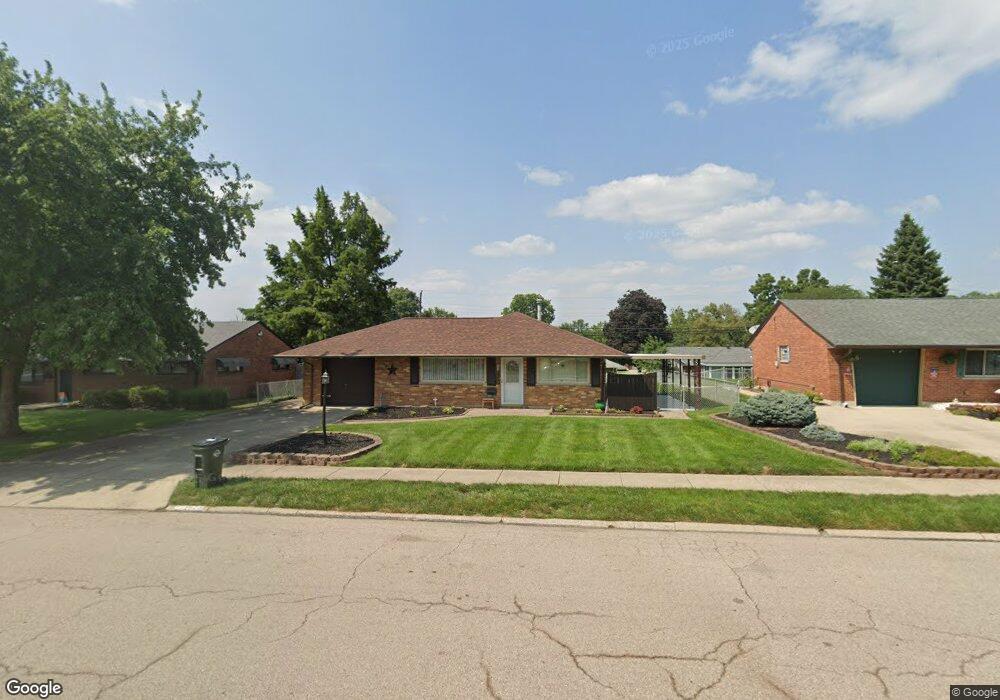
1625 W Stroop Rd Dayton, OH 45439
Estimated Value: $180,000 - $193,000
3
Beds
1
Bath
1,040
Sq Ft
$179/Sq Ft
Est. Value
About This Home
This home is located at 1625 W Stroop Rd, Dayton, OH 45439 and is currently estimated at $185,876, approximately $178 per square foot. 1625 W Stroop Rd is a home located in Montgomery County with nearby schools including Southdale Elementary School, Van Buren Middle School, and Kettering Fairmont High School.
Ownership History
Date
Name
Owned For
Owner Type
Purchase Details
Closed on
Sep 1, 2021
Sold by
Moore Janet G and The Moore Family Revocable Liv
Bought by
Moore Janet G
Current Estimated Value
Purchase Details
Closed on
Apr 29, 2002
Sold by
Moore Lige G and Moore Janet G
Bought by
Moore Lige G and Moore Janet G
Create a Home Valuation Report for This Property
The Home Valuation Report is an in-depth analysis detailing your home's value as well as a comparison with similar homes in the area
Home Values in the Area
Average Home Value in this Area
Purchase History
| Date | Buyer | Sale Price | Title Company |
|---|---|---|---|
| Moore Janet G | -- | None Available | |
| Moore Lige G | -- | -- |
Source: Public Records
Tax History
| Year | Tax Paid | Tax Assessment Tax Assessment Total Assessment is a certain percentage of the fair market value that is determined by local assessors to be the total taxable value of land and additions on the property. | Land | Improvement |
|---|---|---|---|---|
| 2025 | $2,487 | $48,380 | $10,850 | $37,530 |
| 2024 | $2,456 | $48,380 | $10,850 | $37,530 |
| 2023 | $2,456 | $48,380 | $10,850 | $37,530 |
| 2022 | $1,793 | $31,270 | $7,000 | $24,270 |
| 2021 | $1,661 | $31,270 | $7,000 | $24,270 |
| 2020 | $1,662 | $31,270 | $7,000 | $24,270 |
| 2019 | $1,632 | $28,300 | $7,000 | $21,300 |
| 2018 | $1,641 | $28,300 | $7,000 | $21,300 |
| 2017 | $1,513 | $28,300 | $7,000 | $21,300 |
| 2016 | $1,619 | $28,440 | $7,000 | $21,440 |
| 2015 | $1,548 | $28,440 | $7,000 | $21,440 |
| 2014 | $1,548 | $28,440 | $7,000 | $21,440 |
| 2012 | -- | $31,130 | $8,400 | $22,730 |
Source: Public Records
Map
Nearby Homes
- 2090 Mattis Dr
- 3743 Cordell Dr
- 4301 Tait Rd
- 2218 Finland Dr
- 3596 Tait Rd
- 4304 Harbison St
- 2183 Los Arrow Dr
- 4476 Hannaford St
- 3497 Tall Timber Trail
- 4518 Harbison St
- 4515 Harbison St
- 3285 Southdale Dr Unit 4
- 2337 Ned Dr
- 4528 Southern Dr
- 5100 Oak Ave
- 3225 Southdale Dr Unit 1
- 4524 Royal Ridge Way
- 1237 Laurelwood Rd
- 1212 Laurelwood Rd
- 1243 Ridgeview Ave
- 1613 W Stroop Rd
- 1637 W Stroop Rd
- 1620 Hillwood Dr
- 1632 Hillwood Dr
- 1608 Hillwood Dr
- 1601 W Stroop Rd
- 1649 W Stroop Rd
- 1644 Hillwood Dr
- 1596 Hillwood Dr
- 1597 W Stroop Rd
- 1661 W Stroop Rd
- 1926 W Stroop Rd
- 1916 W Stroop Rd
- 1656 Hillwood Dr
- 1584 Hillwood Dr
- 1942 W Stroop Rd
- 1621 Hillwood Dr
- 1956 W Stroop Rd
- 1633 Hillwood Dr
- 1585 W Stroop Rd
Your Personal Tour Guide
Ask me questions while you tour the home.