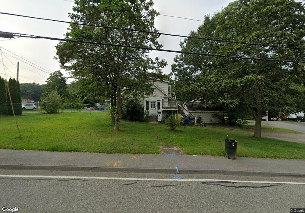
163 Chestnut St Randolph, MA 02368
North Randolph NeighborhoodEstimated Value: $405,000 - $566,000
2
Beds
3
Baths
1,040
Sq Ft
$461/Sq Ft
Est. Value
About This Home
This home is located at 163 Chestnut St, Randolph, MA 02368 and is currently estimated at $479,713, approximately $461 per square foot. 163 Chestnut St is a home located in Norfolk County with nearby schools including Randolph High School and Lighthouse Baptist Christian Academy.
Ownership History
Date
Name
Owned For
Owner Type
Purchase Details
Closed on
Sep 22, 2000
Sold by
Adams Donald B and Adams Donald E
Bought by
Daly Joseph W
Current Estimated Value
Home Financials for this Owner
Home Financials are based on the most recent Mortgage that was taken out on this home.
Original Mortgage
$96,000
Outstanding Balance
$34,741
Interest Rate
8%
Mortgage Type
Purchase Money Mortgage
Estimated Equity
$444,972
Purchase Details
Closed on
Oct 27, 1995
Sold by
Adams Donald B and Adams Donald E
Bought by
Perez David and Perez Gloria H
Purchase Details
Closed on
Apr 7, 1993
Sold by
Adams Donald B and Adams Donald E
Bought by
Hamilton Shelley D
Home Financials for this Owner
Home Financials are based on the most recent Mortgage that was taken out on this home.
Original Mortgage
$50,000
Interest Rate
7.45%
Create a Home Valuation Report for This Property
The Home Valuation Report is an in-depth analysis detailing your home's value as well as a comparison with similar homes in the area
Home Values in the Area
Average Home Value in this Area
Purchase History
| Date | Buyer | Sale Price | Title Company |
|---|---|---|---|
| Daly Joseph W | $120,000 | -- | |
| Perez David | $139,000 | -- | |
| Hamilton Shelley D | $124,900 | -- |
Source: Public Records
Mortgage History
| Date | Status | Borrower | Loan Amount |
|---|---|---|---|
| Open | Hamilton Shelley D | $96,000 | |
| Previous Owner | Hamilton Shelley D | $95,000 | |
| Previous Owner | Hamilton Shelley D | $50,000 |
Source: Public Records
Tax History
| Year | Tax Paid | Tax Assessment Tax Assessment Total Assessment is a certain percentage of the fair market value that is determined by local assessors to be the total taxable value of land and additions on the property. | Land | Improvement |
|---|---|---|---|---|
| 2025 | $5,068 | $436,500 | $253,300 | $183,200 |
| 2024 | $4,903 | $428,200 | $248,300 | $179,900 |
| 2023 | $4,718 | $390,600 | $225,800 | $164,800 |
| 2022 | $4,673 | $343,600 | $188,100 | $155,500 |
| 2021 | $4,323 | $292,500 | $156,800 | $135,700 |
| 2020 | $4,251 | $285,100 | $156,800 | $128,300 |
| 2019 | $4,048 | $270,200 | $149,300 | $120,900 |
| 2018 | $3,916 | $246,600 | $135,700 | $110,900 |
| 2017 | $3,844 | $237,600 | $129,200 | $108,400 |
| 2016 | $3,713 | $213,500 | $117,400 | $96,100 |
| 2015 | $3,573 | $197,400 | $111,900 | $85,500 |
Source: Public Records
Map
Nearby Homes
- 51 Himoor Cir
- 72 Canton St
- 195 High St
- 875 N Main St
- 20 Simmonds Blvd Unit 20
- 18 Simmonds Blvd Unit 18
- 8 Simmonds Blvd Unit 8
- 22 Simmonds Blvd Unit 22
- 10 Simmonds Blvd Unit 10
- 24 Simmonds Blvd Unit 24
- 6 Simmonds Blvd Unit 6
- 4 Franklin Square Unit 4F
- 34 Orchard St
- 10 Michael Rd
- 9 Royal Crest Dr Unit 12
- 43 Emily Jeffers Rd
- 23 Old St
- 591 N Main St
- 79 Gold St
- 232 Canton St Unit 308
- 167 Chestnut St
- 6 Lebreque Way
- 175 Chestnut St
- 170 Chestnut St
- 107 Chestnut St
- 172 Chestnut St
- 168 Chestnut St
- 5 Ferry Rd
- 174 Chestnut St
- 179 Chestnut St
- 166 Chestnut St
- 5 Lambert Rd
- 176 Chestnut St
- 99 Chestnut St
- 101 Chestnut St
- 99 Chestnut St Unit 99
- 99 Chestnut St Unit Rosemont Sq
- 180 Chestnut St
- 9 Lambert Rd
- 44 Marion St
Your Personal Tour Guide
Ask me questions while you tour the home.