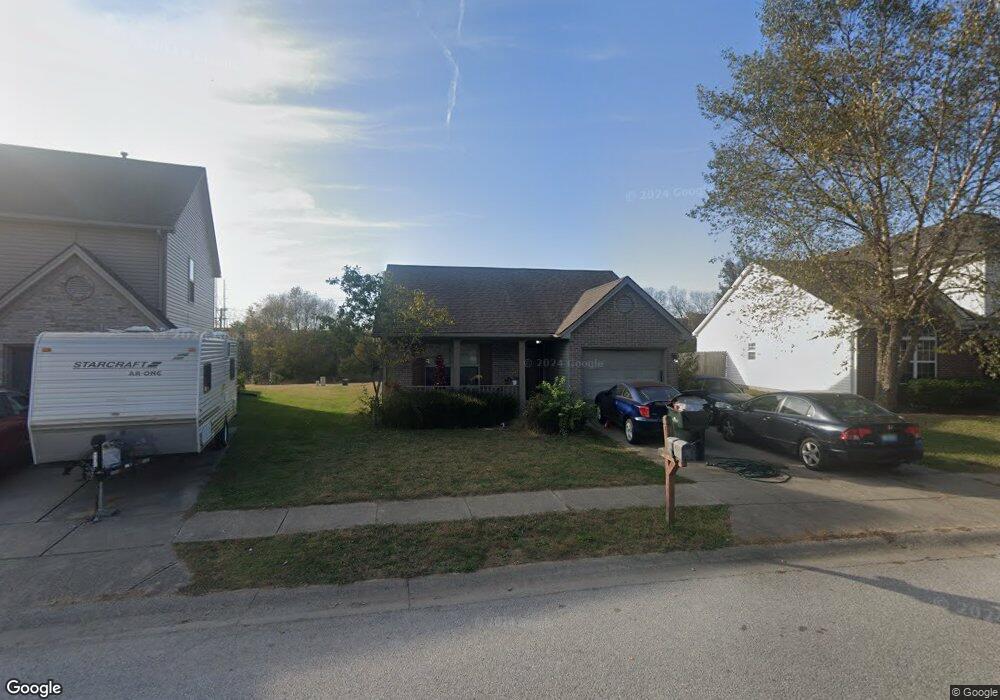
163 Ransom Trace Georgetown, KY 40324
Bradford Place NeighborhoodEstimated Value: $259,000 - $276,000
3
Beds
2
Baths
1,269
Sq Ft
$211/Sq Ft
Est. Value
About This Home
This home is located at 163 Ransom Trace, Georgetown, KY 40324 and is currently estimated at $267,602, approximately $210 per square foot. 163 Ransom Trace is a home located in Scott County with nearby schools including Southern Elementary School, Georgetown Middle School, and Scott County High School.
Ownership History
Date
Name
Owned For
Owner Type
Purchase Details
Closed on
Aug 29, 2024
Sold by
Pursel Family Revocable Living Trust and Pursel Carroll R
Bought by
Carroll R Pursel And Nancy E Pursel Irrevocab and Fain
Current Estimated Value
Purchase Details
Closed on
Mar 18, 2015
Sold by
The Pursel Family Revocable Living Trust
Bought by
Pursel Carroll R and Pursel Nancy E
Home Financials for this Owner
Home Financials are based on the most recent Mortgage that was taken out on this home.
Original Mortgage
$67,500
Interest Rate
3.69%
Mortgage Type
New Conventional
Create a Home Valuation Report for This Property
The Home Valuation Report is an in-depth analysis detailing your home's value as well as a comparison with similar homes in the area
Home Values in the Area
Average Home Value in this Area
Purchase History
| Date | Buyer | Sale Price | Title Company |
|---|---|---|---|
| Carroll R Pursel And Nancy E Pursel Irrevocab | -- | None Listed On Document | |
| Carroll R Pursel And Nancy E Pursel Irrevocab | -- | None Listed On Document | |
| Pursel Carroll R | -- | Rainbow Title Company Inc |
Source: Public Records
Mortgage History
| Date | Status | Borrower | Loan Amount |
|---|---|---|---|
| Previous Owner | Pursel Carroll R | $67,500 |
Source: Public Records
Tax History
| Year | Tax Paid | Tax Assessment Tax Assessment Total Assessment is a certain percentage of the fair market value that is determined by local assessors to be the total taxable value of land and additions on the property. | Land | Improvement |
|---|---|---|---|---|
| 2025 | $1,787 | $200,600 | $0 | $0 |
| 2024 | $1,748 | $194,400 | $0 | $0 |
| 2023 | $1,672 | $184,400 | $35,000 | $149,400 |
| 2022 | $1,406 | $165,400 | $30,000 | $135,400 |
| 2021 | $1,451 | $154,000 | $30,000 | $124,000 |
| 2020 | $1,214 | $141,300 | $30,000 | $111,300 |
| 2019 | $1,185 | $135,800 | $0 | $0 |
| 2018 | $1,139 | $131,300 | $0 | $0 |
| 2017 | $1,096 | $125,640 | $0 | $0 |
| 2016 | $961 | $119,292 | $0 | $0 |
| 2015 | $908 | $113,500 | $0 | $0 |
| 2014 | $941 | $113,496 | $0 | $0 |
| 2011 | $70 | $113,496 | $0 | $0 |
Source: Public Records
Map
Nearby Homes
- 115 Victor Place
- 199 Hawthorne Dr
- 113 Walden Cove Unit 3I
- 232 W Showalter Dr
- 1215 Seminole Trail
- 106 Somerset Cove
- 251 W Showalter Dr
- 108 Pinwheel Ct
- 110 Capella Way
- 512 Pocahontas Trail
- 140 Magellan Ln
- 264 W Showalter Dr
- 144 Magellan Ln
- The Bedford Hill Plan at South Crossing - Trend Collection
- The Barclay Point Plan at South Crossing - Trend Collection
- The Gaines Mill Plan at South Crossing - Trend Collection
- The Dover Glen Plan at South Crossing - Trend Collection
- The Sycamore Bend Plan at South Crossing - Trend Collection
- The Oak Bluff Plan at South Crossing - Trend Collection
- Hampton Falls Plan at South Crossing - Trend Collection
- 161 Ransom Trace
- 167 Ransom Trace
- 159 Ransom Trace
- 160 Ransom Trace
- 169 Ransom Trace
- 158 Ransom Trace
- 155 Lovett Park
- 153 Lovett Park
- 171 Ransom Trace
- 157 Ransom Trace
- 156 Ransom Trace
- 151 Lovett Park
- 173 Ransom Trace
- 156 Lovett Park
- 149 Lovett Park
- 154 Ransom Trace
- 153 Ransom Trace
- 147 Lovett Park
- 175 Ransom Trace
Your Personal Tour Guide
Ask me questions while you tour the home.