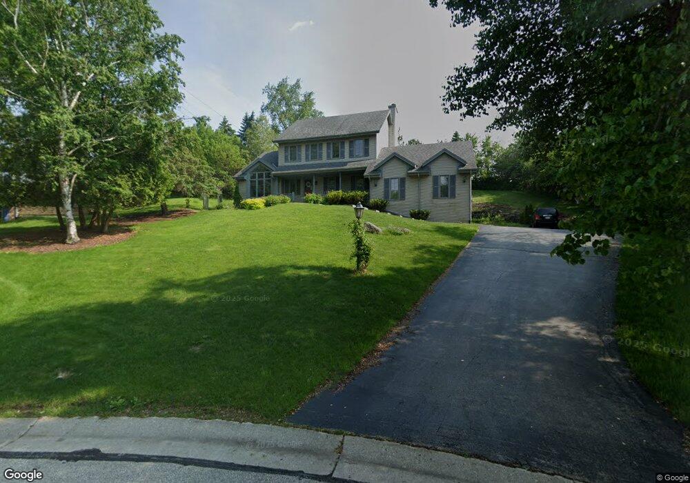
1630 Hancock Ct Brookfield, WI 53045
Estimated Value: $559,000 - $613,000
3
Beds
3
Baths
2,281
Sq Ft
$254/Sq Ft
Est. Value
About This Home
This home is located at 1630 Hancock Ct, Brookfield, WI 53045 and is currently estimated at $580,402, approximately $254 per square foot. 1630 Hancock Ct is a home located in Waukesha County with nearby schools including Brookfield Elementary School, Wisconsin Hills Middle School, and Brookfield Central High School.
Ownership History
Date
Name
Owned For
Owner Type
Purchase Details
Closed on
Feb 17, 2006
Sold by
Marciniak Anthony R and Marciniak Cynthia A
Bought by
Cao Xiaokang and Wang Mei
Current Estimated Value
Home Financials for this Owner
Home Financials are based on the most recent Mortgage that was taken out on this home.
Original Mortgage
$264,000
Outstanding Balance
$148,622
Interest Rate
6.2%
Mortgage Type
Fannie Mae Freddie Mac
Estimated Equity
$431,780
Purchase Details
Closed on
Mar 29, 2002
Sold by
Manders William J and Manders Janean M
Bought by
Marciniak Anthony R and Marciniak Cynthia A
Home Financials for this Owner
Home Financials are based on the most recent Mortgage that was taken out on this home.
Original Mortgage
$215,000
Interest Rate
6.37%
Mortgage Type
Purchase Money Mortgage
Create a Home Valuation Report for This Property
The Home Valuation Report is an in-depth analysis detailing your home's value as well as a comparison with similar homes in the area
Home Values in the Area
Average Home Value in this Area
Purchase History
| Date | Buyer | Sale Price | Title Company |
|---|---|---|---|
| Cao Xiaokang | -- | None Available | |
| Marciniak Anthony R | $271,000 | -- |
Source: Public Records
Mortgage History
| Date | Status | Borrower | Loan Amount |
|---|---|---|---|
| Open | Cao Xiaokang | $264,000 | |
| Previous Owner | Marciniak Anthony R | $215,000 |
Source: Public Records
Tax History Compared to Growth
Tax History
| Year | Tax Paid | Tax Assessment Tax Assessment Total Assessment is a certain percentage of the fair market value that is determined by local assessors to be the total taxable value of land and additions on the property. | Land | Improvement |
|---|---|---|---|---|
| 2024 | $4,859 | $437,600 | $144,500 | $293,100 |
| 2023 | $4,858 | $437,600 | $144,500 | $293,100 |
| 2022 | $5,069 | $356,600 | $139,100 | $217,500 |
| 2021 | $6,481 | $356,600 | $139,100 | $217,500 |
| 2020 | $5,605 | $356,600 | $139,100 | $217,500 |
| 2019 | $5,382 | $356,600 | $139,100 | $217,500 |
| 2018 | $4,904 | $316,800 | $90,000 | $226,800 |
| 2017 | $4,911 | $316,800 | $90,000 | $226,800 |
| 2016 | $4,982 | $316,800 | $90,000 | $226,800 |
| 2015 | $4,956 | $316,800 | $90,000 | $226,800 |
| 2014 | $5,141 | $316,800 | $90,000 | $226,800 |
| 2013 | $5,141 | $316,800 | $90,000 | $226,800 |
Source: Public Records
Map
Nearby Homes
- 1660 Constitution Dr
- 19775 Trilby Ct
- 20025 Freedom Ct
- 1375 Barrington Woods Dr
- 1345 Overlook Cir
- 19250 Benington Dr
- 950 N Barker Rd
- 1485 N Brookfield Rd
- 20780 Tennyson Dr
- 1135 Greenridge Terrace
- 890 Janacek Rd
- 18660 Bonnie Ln
- 19145 Arlyne Ct
- 21300 Astolat Dr
- 18880 Toldt Woods Dr Unit 6
- 21905 W North Ave
- 2480 Lionel Ct
- Lt115 Berwick Ct
- Lt118 Berwick Ct
- Lt117 Berwick Ct
- 1640 Hancock Ct
- 1620 Constitution Dr
- 1555 Liberty Ct
- 1600 Constitution Dr
- 1650 Hancock Ct
- 1525 Liberty Ct
- 1550 Liberty Ct
- 1590 Constitution Dr
- 1555 Brian Ct
- 1645 Constitution Dr
- 1615 Constitution Dr
- 1505 Liberty Ct
- 1680 Constitution Dr
- 1570 Constitution Dr
- 1675 Constitution Dr
- 1535 Brian Ct
- 1530 Liberty Ct
- 19865 Gebhardt Rd
- 20115 Colony Ct
- 1585 Constitution Dr