
Seller's Agent in 2025
Connor Matthews
Home Realty Group
(541) 636-3234
4 in this area
39 Total Sales
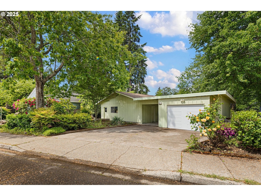


Tucked away on a small dead end drive in Ferry Street Bridge near beloved Bond Park, this charming 3-bedroom, 1.5-bath home offers the perfect blend of privacy, potential, and functionality. Step onto the welcoming front deck and into a warm, inviting interior that’s ready for your personal touch. Big open living room with wood stove and bay window ledge, galley kitchen with ample prep space and extra eating area, laminate floors throughout. Enjoy morning coffee or evening gatherings on the spacious covered back deck overlooking the peaceful backyard. The detached one-car garage is complemented by a 400 sq ft workshop/mudroom/utility room which is attached to the home—not included in the home’s square footage—that could easily be converted or transformed into family room/office/gym but is perfect for almost any hobbyist. In addition, a 102 sq ft detached studio in the backyard offers a quiet retreat for creative projects, a home office, or work space. The layout of the home is simple and cohesive and presents opportunity for some instant sweat equity! If you're looking for a property that has ADU potential, you won't want to miss seeing this one - the detached garage, attached workshop or detached studio all offer potential (buyer to verify to their satisfaction). Whether you're looking to customize your dream home or invest in a property with flexible potential, this one checks all the boxes.
Last Agent to Sell the Property
Home Realty Group License #201246401 Listed on: 05/16/2025
| Date | Type | Sale Price | Title Company |
|---|---|---|---|
| Warranty Deed | $405,000 | First American Title | |
| Warranty Deed | $239,900 | Western Title & Escrow Compa | |
| Warranty Deed | $123,000 | Western Pioneer Title Co |
| Date | Status | Loan Amount | Loan Type |
|---|---|---|---|
| Open | $384,750 | New Conventional | |
| Previous Owner | $109,061 | FHA |
| Date | Event | Price | List to Sale | Price per Sq Ft |
|---|---|---|---|---|
| 06/20/2025 06/20/25 | Sold | $405,000 | -3.3% | $332 / Sq Ft |
| 05/22/2025 05/22/25 | Pending | -- | -- | -- |
| 05/16/2025 05/16/25 | For Sale | $419,000 | -- | $343 / Sq Ft |
| Year | Tax Paid | Tax Assessment Tax Assessment Total Assessment is a certain percentage of the fair market value that is determined by local assessors to be the total taxable value of land and additions on the property. | Land | Improvement |
|---|---|---|---|---|
| 2025 | $4,427 | $227,220 | -- | -- |
| 2024 | $4,372 | $220,602 | -- | -- |
| 2023 | $4,372 | $214,177 | -- | -- |
| 2022 | $4,096 | $207,939 | $0 | $0 |
| 2021 | $3,847 | $201,883 | $0 | $0 |
| 2020 | $3,861 | $196,003 | $0 | $0 |
| 2019 | $3,729 | $190,295 | $0 | $0 |
| 2018 | $3,510 | $179,372 | $0 | $0 |
| 2017 | $3,352 | $179,372 | $0 | $0 |
| 2016 | $3,220 | $174,148 | $0 | $0 |
| 2015 | $3,120 | $169,076 | $0 | $0 |
| 2014 | $3,050 | $164,151 | $0 | $0 |
Seller's Agent in 2025
Connor Matthews
Home Realty Group
(541) 636-3234
4 in this area
39 Total Sales
Seller Co-Listing Agent in 2025
Tiffany Matthews
Home Realty Group
(541) 968-3233
12 in this area
134 Total Sales
Buyer's Agent in 2025
Katie Colter
Colter Home Co.
(541) 261-1010
15 in this area
142 Total Sales
Source: Regional Multiple Listing Service (RMLS)
MLS Number: 717455872
APN: 0164945
Disclaimer: Certain information contained herein is derived from information provided by parties other than Homes.com. All information provided is deemed reliable, but is not guaranteed to be accurate and should be independently verified.
![]() The content relating to real estate for sale on this web site comes in part from the IDX program of the RMLS™ of Portland, Oregon. Real estate listings held by brokerage firms other than Ten-X are marked with the RMLS™ logo, and detailed information about these properties includes the names of the listing brokers. Listing content is copyright © 2026 RMLS™, Portland, Oregon. Some properties which appear for sale on this web site may subsequently have sold or may no longer be available. All information provided is deemed reliable but is not guaranteed and should be independently verified.
The content relating to real estate for sale on this web site comes in part from the IDX program of the RMLS™ of Portland, Oregon. Real estate listings held by brokerage firms other than Ten-X are marked with the RMLS™ logo, and detailed information about these properties includes the names of the listing brokers. Listing content is copyright © 2026 RMLS™, Portland, Oregon. Some properties which appear for sale on this web site may subsequently have sold or may no longer be available. All information provided is deemed reliable but is not guaranteed and should be independently verified.
Ask me questions while you tour the home.