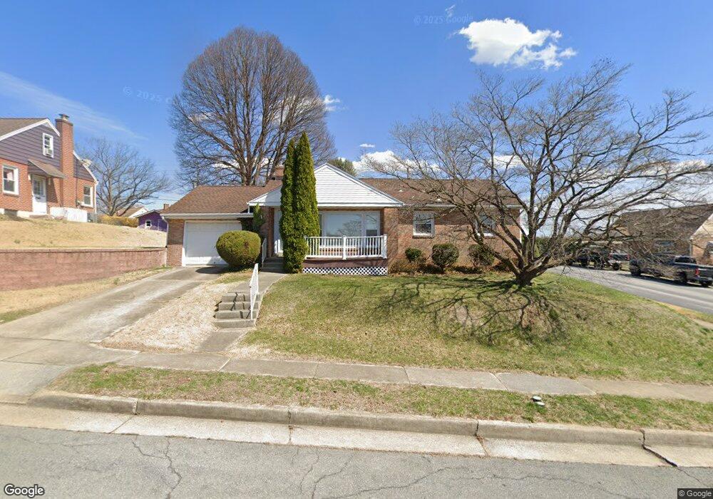
1632 Kenhorst Blvd Reading, PA 19607
Estimated Value: $243,148 - $263,000
3
Beds
1
Bath
980
Sq Ft
$258/Sq Ft
Est. Value
About This Home
This home is located at 1632 Kenhorst Blvd, Reading, PA 19607 and is currently estimated at $253,287, approximately $258 per square foot. 1632 Kenhorst Blvd is a home located in Berks County with nearby schools including Governor Mifflin Intermediate School, Mifflin Park Elementary School, and Governor Mifflin Middle School.
Ownership History
Date
Name
Owned For
Owner Type
Purchase Details
Closed on
Dec 13, 2002
Sold by
Spengler Barry D and Spengler Georgine M
Bought by
Williams Kenneth A
Current Estimated Value
Home Financials for this Owner
Home Financials are based on the most recent Mortgage that was taken out on this home.
Original Mortgage
$92,900
Interest Rate
6.09%
Purchase Details
Closed on
Nov 29, 2001
Sold by
Andrews Perry C
Bought by
Spengler Barry D and Spengler Georgine M
Create a Home Valuation Report for This Property
The Home Valuation Report is an in-depth analysis detailing your home's value as well as a comparison with similar homes in the area
Home Values in the Area
Average Home Value in this Area
Purchase History
| Date | Buyer | Sale Price | Title Company |
|---|---|---|---|
| Williams Kenneth A | $99,900 | -- | |
| Spengler Barry D | $91,000 | -- |
Source: Public Records
Mortgage History
| Date | Status | Borrower | Loan Amount |
|---|---|---|---|
| Previous Owner | Williams Kenneth A | $92,900 |
Source: Public Records
Tax History Compared to Growth
Tax History
| Year | Tax Paid | Tax Assessment Tax Assessment Total Assessment is a certain percentage of the fair market value that is determined by local assessors to be the total taxable value of land and additions on the property. | Land | Improvement |
|---|---|---|---|---|
| 2025 | $1,090 | $73,500 | $34,100 | $39,400 |
| 2024 | $3,253 | $73,500 | $34,100 | $39,400 |
| 2023 | $3,166 | $73,500 | $34,100 | $39,400 |
| 2022 | $3,129 | $73,500 | $34,100 | $39,400 |
| 2021 | $3,092 | $73,500 | $34,100 | $39,400 |
| 2020 | $3,092 | $73,500 | $34,100 | $39,400 |
| 2019 | $3,055 | $73,500 | $34,100 | $39,400 |
| 2018 | $3,003 | $73,500 | $34,100 | $39,400 |
| 2017 | $2,945 | $73,500 | $34,100 | $39,400 |
| 2016 | $934 | $73,500 | $34,100 | $39,400 |
| 2015 | $934 | $73,500 | $34,100 | $39,400 |
| 2014 | $934 | $73,500 | $34,100 | $39,400 |
Source: Public Records
Map
Nearby Homes
- 1609 Fayette Ave
- 1531 Fayette Ave
- 1424 Commonwealth Blvd
- 1602 Crowder Ave
- 733 Philadelphia Ave
- 823 Fritz Ave
- 715 Tamarack Trail
- 705 Cameron St
- 0 Cedar Top Rd
- 602 Harding Ave
- 17 Doe Run
- 979 New Holland Rd
- 1407 Lancaster Ave
- 123 High Blvd
- 511 Grill Ave
- 1501 Gregg Ave
- 6 Rim View Ln
- 617 Meade Tc
- 512 Mifflin Blvd
- 1020 Meade St
- 1647 Cortland Ave
- 1624 Kenhorst Blvd
- 1618 Kenhorst Blvd
- 1638 Kenhorst Blvd
- 1633 Cortland Ave
- 1648 Cortland Ave
- 1644 Cortland Ave
- 1612 Kenhorst Blvd
- 1629 Kenhorst Blvd
- 1633 Kenhorst Blvd
- 1623 Kenhorst Blvd
- 1629 Cortland Ave
- 1644 Kenhorst Blvd
- 1619 Kenhorst Blvd
- 1640 Cortland Ave
- 1608 Kenhorst Blvd
- 1637 Kenhorst Blvd
- 1636 Cortland Ave
- 1625 Cortland Ave
- 1613 Kenhorst Blvd