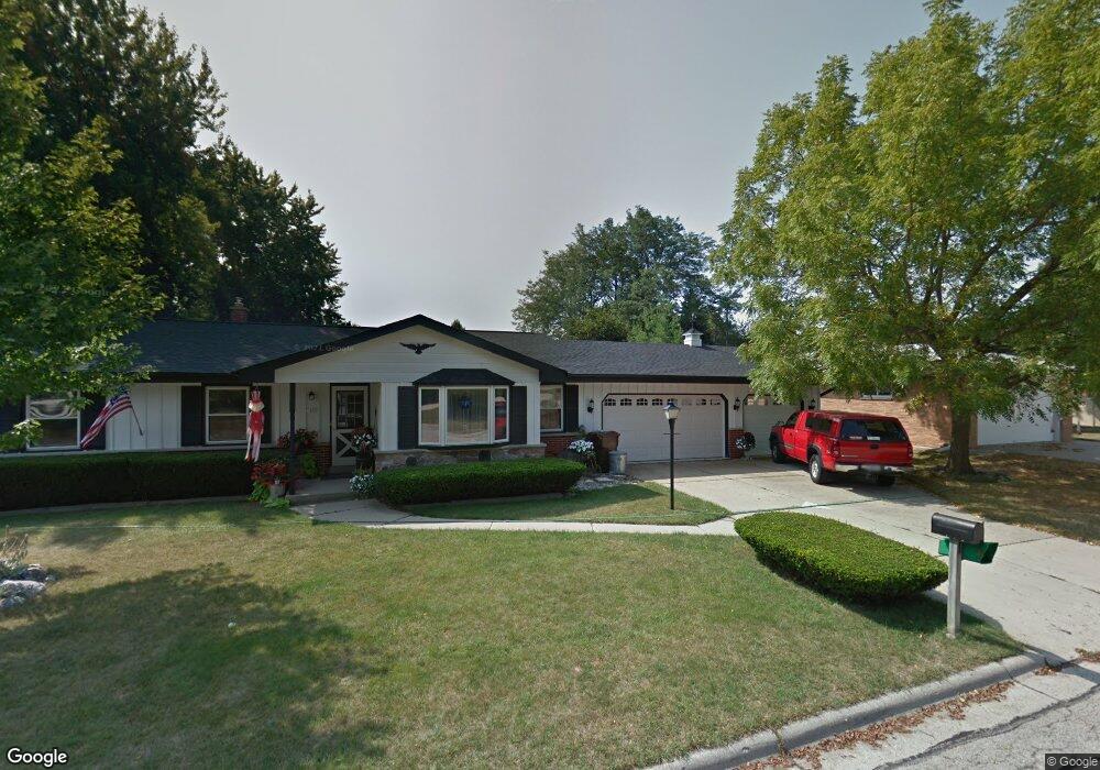
1633 Carroll Ave South Milwaukee, WI 53172
Estimated Value: $362,717 - $386,000
--
Bed
--
Bath
1,525
Sq Ft
$246/Sq Ft
Est. Value
About This Home
This home is located at 1633 Carroll Ave, South Milwaukee, WI 53172 and is currently estimated at $374,429, approximately $245 per square foot. 1633 Carroll Ave is a home located in Milwaukee County with nearby schools including Rawson Elementary School, South Milwaukee Middle School, and South Milwaukee High School.
Ownership History
Date
Name
Owned For
Owner Type
Purchase Details
Closed on
Sep 18, 2020
Sold by
Milwaukee County
Bought by
Borck Byron E and Borck Jennifer E
Current Estimated Value
Purchase Details
Closed on
May 6, 2020
Sold by
Montpas Richard P and Montpas Nancy M
Bought by
Virgen Oscar and Virgen Jessica
Home Financials for this Owner
Home Financials are based on the most recent Mortgage that was taken out on this home.
Original Mortgage
$227,905
Interest Rate
3.5%
Mortgage Type
New Conventional
Create a Home Valuation Report for This Property
The Home Valuation Report is an in-depth analysis detailing your home's value as well as a comparison with similar homes in the area
Home Values in the Area
Average Home Value in this Area
Purchase History
| Date | Buyer | Sale Price | Title Company |
|---|---|---|---|
| Borck Byron E | -- | None Available | |
| Virgen Oscar | $239,900 | None Available |
Source: Public Records
Mortgage History
| Date | Status | Borrower | Loan Amount |
|---|---|---|---|
| Previous Owner | Virgen Oscar | $227,905 |
Source: Public Records
Tax History Compared to Growth
Tax History
| Year | Tax Paid | Tax Assessment Tax Assessment Total Assessment is a certain percentage of the fair market value that is determined by local assessors to be the total taxable value of land and additions on the property. | Land | Improvement |
|---|---|---|---|---|
| 2024 | $2,579 | $264,500 | $67,500 | $197,000 |
| 2023 | $5,047 | $264,500 | $67,500 | $197,000 |
| 2022 | $5,132 | $264,500 | $67,500 | $197,000 |
| 2021 | $4,922 | $183,000 | $54,000 | $129,000 |
| 2020 | $4,934 | $183,000 | $54,000 | $129,000 |
| 2019 | $4,839 | $183,000 | $54,000 | $129,000 |
| 2018 | $4,688 | $183,000 | $54,000 | $129,000 |
| 2017 | $4,669 | $183,000 | $54,000 | $129,000 |
| 2016 | $4,565 | $183,000 | $54,000 | $129,000 |
| 2015 | $4,592 | $183,000 | $54,000 | $129,000 |
| 2014 | $4,482 | $183,000 | $54,000 | $129,000 |
| 2013 | $4,829 | $183,000 | $54,000 | $129,000 |
Source: Public Records
Map
Nearby Homes
- 1729 Hickory St
- 1301 College Ave Unit 5
- 6240 S Creekside Dr Unit 2
- 6035 S Crosswinds Dr Unit 7
- 6195 Walnut Ln Unit 65
- 2051 E Poplar Ave
- 6010 S Crosswinds Dr Unit 7
- 6040 S Buckhorn Ave
- 5829 S Delaware Ave Unit 29A
- 3373 E Henry Ave
- 201 N Chicago Ave
- 5720 S Elaine Ave
- 3614 E Kimberly Ave
- 6196 S Tarbert Ct
- 3745 E Klieforth Ave
- 629 Park Ave
- 1722 Manitoba Ave
- 6961 S Rolling Meadows Ct Unit 101
- 616 Aspen St
- 5442 S Nicholson Ave Unit 5442
- 204 Cypress Ct
- 1637 Carroll Ave
- 208 Cypress Ct
- 1632 Carroll Ave Unit 3 upper unit
- 1629 Carroll Ave
- 1636 Carroll Ave
- 205 Hemlock Ct
- 205 Cypress Ct
- 201 Hemlock Ct
- 209 Hemlock Ct
- 1640 Carroll Ave
- 213 Hemlock Ct
- 212 Cypress Ct
- 209 Cypress Ct
- 1642 Carroll Ave
- 1643 College Ave
- 216 Cypress Ct
- 213 Cypress Ct
- 1644 Carroll Ave
- 202 Laurel Ln