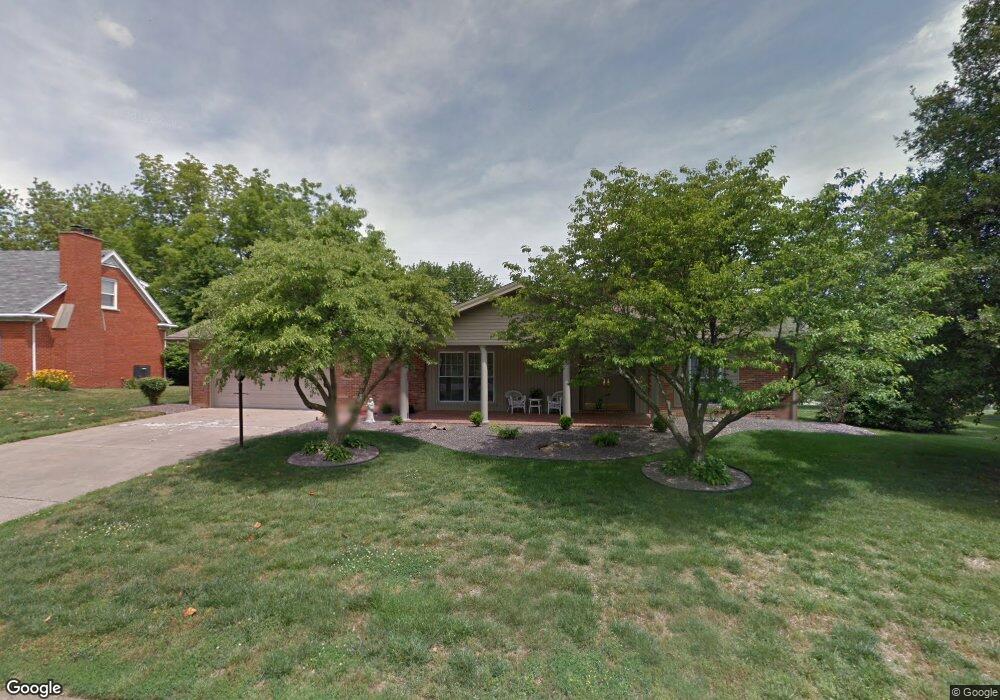
1633 Hawthorne Dr Mount Vernon, IN 47620
Estimated Value: $240,000 - $319,000
3
Beds
3
Baths
2,379
Sq Ft
$122/Sq Ft
Est. Value
About This Home
This home is located at 1633 Hawthorne Dr, Mount Vernon, IN 47620 and is currently estimated at $290,218, approximately $121 per square foot. 1633 Hawthorne Dr is a home located in Posey County with nearby schools including Mount Vernon Junior High School, Mount Vernon High School, and St. Matthew Elementary School.
Ownership History
Date
Name
Owned For
Owner Type
Purchase Details
Closed on
Feb 7, 2017
Sold by
Evans Michael D
Bought by
Simon Randall E and Simon Nancy Jean
Current Estimated Value
Home Financials for this Owner
Home Financials are based on the most recent Mortgage that was taken out on this home.
Original Mortgage
$165,600
Outstanding Balance
$83,432
Interest Rate
4.12%
Mortgage Type
New Conventional
Estimated Equity
$206,786
Create a Home Valuation Report for This Property
The Home Valuation Report is an in-depth analysis detailing your home's value as well as a comparison with similar homes in the area
Home Values in the Area
Average Home Value in this Area
Purchase History
| Date | Buyer | Sale Price | Title Company |
|---|---|---|---|
| Simon Randall E | -- | None Available |
Source: Public Records
Mortgage History
| Date | Status | Borrower | Loan Amount |
|---|---|---|---|
| Open | Simon Randall E | $165,600 |
Source: Public Records
Tax History Compared to Growth
Tax History
| Year | Tax Paid | Tax Assessment Tax Assessment Total Assessment is a certain percentage of the fair market value that is determined by local assessors to be the total taxable value of land and additions on the property. | Land | Improvement |
|---|---|---|---|---|
| 2024 | $2,410 | $241,000 | $34,900 | $206,100 |
| 2023 | $2,158 | $215,800 | $34,900 | $180,900 |
| 2022 | $2,000 | $200,000 | $34,900 | $165,100 |
| 2021 | $1,808 | $180,800 | $33,300 | $147,500 |
| 2020 | $1,840 | $184,000 | $32,700 | $151,300 |
| 2019 | $1,798 | $179,800 | $31,400 | $148,400 |
| 2018 | $1,702 | $170,200 | $31,400 | $138,800 |
| 2017 | $1,677 | $167,700 | $31,600 | $136,100 |
| 2016 | $1,553 | $155,300 | $29,300 | $126,000 |
| 2014 | $1,703 | $170,300 | $29,300 | $141,000 |
| 2013 | $1,703 | $154,700 | $29,300 | $125,400 |
Source: Public Records
Map
Nearby Homes
- 36 Parkridge Dr
- 20 Parkridge Dr
- 721 Smith Rd
- 1621 Terrace Dr
- 1613 Country Club Rd
- 905 Smith Rd
- 2012 Westridge Dr
- 1810 Tanglewood Dr
- 1108 W 2nd St
- 908 W 4th St
- 521 W 2nd St
- 230 Vine St
- 407 W 4th St
- 311 W Grant St
- 305 Brown St
- 10800 Hwy 69 & Along Ohio River Rd
- 433 Coronado Dr
- 444 Kennedy Dr
- 1230 Dereham Dr
- 1240 Mulberry St
- 1637 Hawthorne Dr
- 1629 Hawthorne Dr
- 1628 Terrace Dr
- 1624 Terrace Dr
- 1632 Terrace Dr
- 739 Magnolia Dr
- 1628 Hawthorne Dr
- 1624 Hawthorne Dr
- 1621 Hawthorne Dr
- 1632 Hawthorne Dr
- 1620 Terrace Dr
- 735 Magnolia Dr
- 42 Parkridge Dr
- 1616 Terrace Dr
- 1620 Hawthorne Dr
- 1625 Terrace Dr
- 1631 Terrace Dr
- 1629 Terrace Dr
- 1635 Terrace Dr
- 736 Magnolia Dr