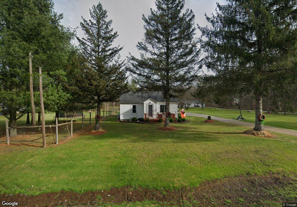
1636 Richman Rd Kimball, MI 48074
Estimated Value: $127,000 - $186,000
3
Beds
1
Bath
1,048
Sq Ft
$153/Sq Ft
Est. Value
About This Home
This home is located at 1636 Richman Rd, Kimball, MI 48074 and is currently estimated at $160,135, approximately $152 per square foot. 1636 Richman Rd is a home located in St. Clair County with nearby schools including Kimball Elementary School, Central Middle School, and Port Huron High School.
Ownership History
Date
Name
Owned For
Owner Type
Purchase Details
Closed on
Oct 10, 2024
Sold by
Baur Amy and Adams Amy
Bought by
Bauer Amy and Bauer Sean
Current Estimated Value
Purchase Details
Closed on
Mar 14, 2013
Sold by
Estate Of Margaret Kinney
Bought by
Adams Amy
Home Financials for this Owner
Home Financials are based on the most recent Mortgage that was taken out on this home.
Original Mortgage
$45,918
Interest Rate
3.49%
Mortgage Type
New Conventional
Create a Home Valuation Report for This Property
The Home Valuation Report is an in-depth analysis detailing your home's value as well as a comparison with similar homes in the area
Home Values in the Area
Average Home Value in this Area
Purchase History
| Date | Buyer | Sale Price | Title Company |
|---|---|---|---|
| Bauer Amy | -- | None Listed On Document | |
| Adams Amy | $45,000 | None Available |
Source: Public Records
Mortgage History
| Date | Status | Borrower | Loan Amount |
|---|---|---|---|
| Previous Owner | Adams Amy | $45,918 |
Source: Public Records
Tax History Compared to Growth
Tax History
| Year | Tax Paid | Tax Assessment Tax Assessment Total Assessment is a certain percentage of the fair market value that is determined by local assessors to be the total taxable value of land and additions on the property. | Land | Improvement |
|---|---|---|---|---|
| 2025 | $1,153 | $68,400 | $0 | $0 |
| 2024 | $653 | $63,600 | $0 | $0 |
| 2023 | $598 | $58,600 | $0 | $0 |
| 2022 | $1,030 | $49,700 | $0 | $0 |
| 2021 | $930 | $44,000 | $0 | $0 |
| 2020 | $930 | $41,100 | $41,100 | $0 |
| 2019 | $913 | $38,400 | $0 | $0 |
| 2018 | $891 | $35,200 | $0 | $0 |
| 2017 | $873 | $39,800 | $0 | $0 |
| 2016 | $534 | $39,800 | $0 | $0 |
| 2015 | -- | $39,700 | $39,700 | $0 |
| 2014 | -- | $37,500 | $37,500 | $0 |
| 2013 | -- | $38,200 | $0 | $0 |
Source: Public Records
Map
Nearby Homes
- 1533 Richman Rd
- 1900 Burns Rd
- 1688 Sturdevant Rd
- 1371 Sturdevant Rd
- 6417 Dove Rd
- 1261 Sturdevant Rd
- 0 Sparling Rd Unit 2210034403
- VL Lambs Rd
- 7710 Sparling Rd
- 1671 Ditty Rd
- 0 Sparling Unit 20230091288
- 00 Griswold Rd
- 8067 Lambs Rd
- 6928 Smiths Creek Rd
- I-69 vac Taylor Dr
- 8237 Lambs Rd
- 355 Henry St
- 2019 Edward Ln E
- 1876 Morningstar Ave
- 6928 Lapeer Rd
- 1654 Richman Rd
- 1635 Richman Rd
- 1645 Richman Rd
- 1629 Richman Rd
- 1630 Richman Rd
- 1653 Richman Rd
- 1666 Richman Rd
- 1625 Richman Rd
- 1669 Richman Rd
- 1621 Richman Rd
- 1613 Richman Rd
- 1671 Richman Rd
- 1675 Richman Rd
- 1678 Richman Rd
- 1605 Richman Rd
- 1597 Richman Rd
- 1698 Richman Rd
- 1687 Richman Rd
- 1687 Richman Rd
- 1589 Richman Rd