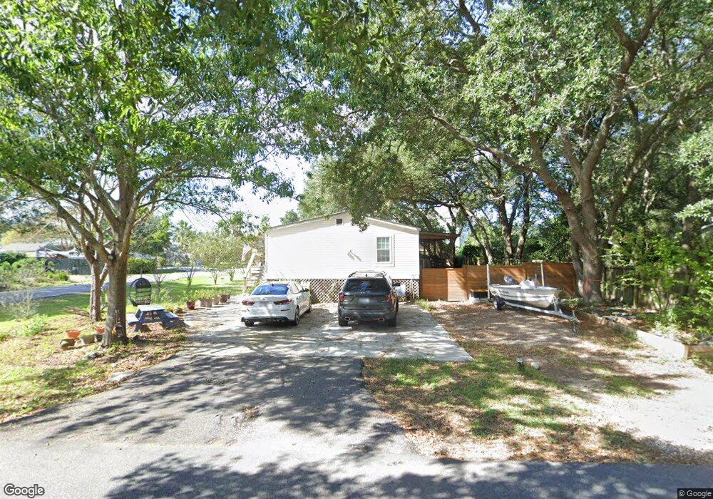
1636 Terns Nest Rd Charleston, SC 29412
James Island NeighborhoodEstimated Value: $413,000 - $525,352
3
Beds
2
Baths
1,716
Sq Ft
$277/Sq Ft
Est. Value
About This Home
This home is located at 1636 Terns Nest Rd, Charleston, SC 29412 and is currently estimated at $476,088, approximately $277 per square foot. 1636 Terns Nest Rd is a home located in Charleston County with nearby schools including James Island Elementary School, Camp Road Middle, and Septima P Clark Corporate Academy.
Ownership History
Date
Name
Owned For
Owner Type
Purchase Details
Closed on
Dec 17, 2021
Sold by
Ridenour William F
Bought by
Ridenour Mary Ann
Current Estimated Value
Purchase Details
Closed on
Dec 16, 2021
Sold by
Ridenour William F
Bought by
Ridenour Mary Ann
Purchase Details
Closed on
Sep 30, 2003
Sold by
Linville Robert F and Linville Carol
Bought by
Ridenour William F
Purchase Details
Closed on
Aug 31, 2001
Sold by
Poole Melody A and Poole Randy P
Bought by
Linville Robert F and Linville Carol
Purchase Details
Closed on
Jun 26, 2001
Sold by
Riverfront Inc
Bought by
Poole Melody A and Poole Randy P
Create a Home Valuation Report for This Property
The Home Valuation Report is an in-depth analysis detailing your home's value as well as a comparison with similar homes in the area
Home Values in the Area
Average Home Value in this Area
Purchase History
| Date | Buyer | Sale Price | Title Company |
|---|---|---|---|
| Ridenour Mary Ann | -- | None Listed On Document | |
| Ridenour Mary Ann | -- | None Listed On Document | |
| Ridenour William F | $143,900 | -- | |
| Ridenour William F | -- | -- | |
| Linville Robert F | -- | -- | |
| Linville Robert F | $100,000 | -- | |
| Poole Melody A | $7,000 | -- |
Source: Public Records
Tax History Compared to Growth
Tax History
| Year | Tax Paid | Tax Assessment Tax Assessment Total Assessment is a certain percentage of the fair market value that is determined by local assessors to be the total taxable value of land and additions on the property. | Land | Improvement |
|---|---|---|---|---|
| 2024 | $1,087 | $7,030 | $0 | $0 |
| 2023 | $1,087 | $7,030 | $0 | $0 |
| 2022 | $989 | $7,030 | $0 | $0 |
| 2021 | $1,609 | $8,170 | $0 | $0 |
| 2020 | $1,587 | $8,170 | $0 | $0 |
| 2019 | $1,482 | $7,080 | $0 | $0 |
| 2017 | $2,433 | $9,170 | $0 | $0 |
| 2016 | $2,355 | $9,170 | $0 | $0 |
| 2015 | $2,229 | $9,170 | $0 | $0 |
| 2014 | $2,064 | $0 | $0 | $0 |
| 2011 | -- | $0 | $0 | $0 |
Source: Public Records
Map
Nearby Homes
- 1624 Wigeon Ln
- 1617 Refuge Run
- 129 Howard Mary Dr Unit A
- 1984 Folly Rd Unit A307
- 1984 Folly Rd Unit A314
- 1984 Folly Rd Unit A202
- 118 Howard Mary Dr Unit 118B
- 1588 Terns Nest Rd
- 133 Alder Cir
- 117 Alder Cir
- 1011 Lighterman Way
- 1621 Folly Creek Way Unit D8
- 1637 Folly Creek Way Unit E12
- 1106 Studdingsail Ln
- 1109 Studdingsail Ln
- 2133 Tides End Rd
- 1821 Folly Rd
- 960 Clearspring Dr
- 1144 Clearspring Dr
- 1685 Old Military Rd
- 95 Wild Wing Ln
- 1992 Wild Wing Ln
- 1630 Terns Nest Rd
- 1642 Terns Nest Rd
- 1990 Wild Wing Ln
- 2006 Covey Ln
- 1637 Wigeon Ln
- 1993 Wild Wing Ln
- 1633 Terns Nest Rd
- 1628 Terns Nest Rd
- 1991 Wild Wing Ln
- 1988 Wild Wing Ln
- 2003 Covey Ln
- 1635 Wigeon Ln
- 1646 Terns Nest Rd
- 1989 Wild Wing Ln
- 2005 Covey Ln
- 1633 Wigeon Ln
- 1987 Wild Wing Ln
- 0 Wild Wing Ln