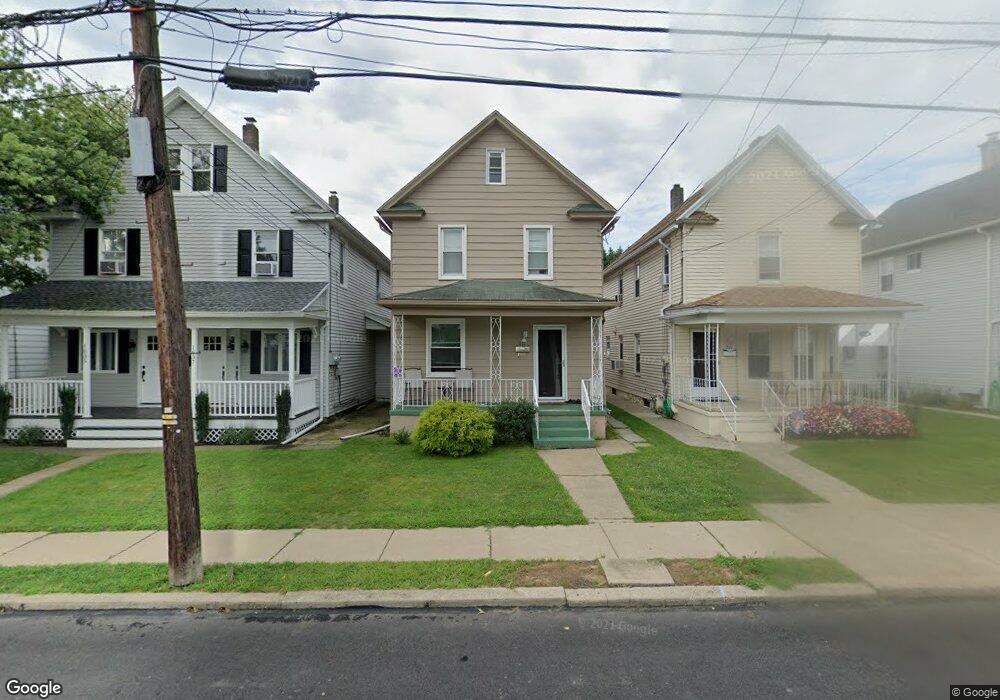
1639 Dorothy St Scranton, PA 18504
Hyde Park NeighborhoodEstimated Value: $192,679 - $226,000
3
Beds
2
Baths
1,890
Sq Ft
$113/Sq Ft
Est. Value
About This Home
This home is located at 1639 Dorothy St, Scranton, PA 18504 and is currently estimated at $212,920, approximately $112 per square foot. 1639 Dorothy St is a home located in Lackawanna County with nearby schools including Longan Elementary School, Adams Elementary School, and Isaac Tripp Elementary School.
Ownership History
Date
Name
Owned For
Owner Type
Purchase Details
Closed on
Oct 23, 2020
Sold by
Jwb Property Group Llc
Bought by
Taylor Emily
Current Estimated Value
Home Financials for this Owner
Home Financials are based on the most recent Mortgage that was taken out on this home.
Original Mortgage
$125,337
Outstanding Balance
$111,277
Interest Rate
2.8%
Mortgage Type
FHA
Estimated Equity
$101,643
Purchase Details
Closed on
Jul 31, 2017
Sold by
Marciano Francis and Marciano Theresa
Bought by
Jwb Property Group Llc
Home Financials for this Owner
Home Financials are based on the most recent Mortgage that was taken out on this home.
Original Mortgage
$123,750
Interest Rate
3.9%
Mortgage Type
Future Advance Clause Open End Mortgage
Create a Home Valuation Report for This Property
The Home Valuation Report is an in-depth analysis detailing your home's value as well as a comparison with similar homes in the area
Home Values in the Area
Average Home Value in this Area
Purchase History
| Date | Buyer | Sale Price | Title Company |
|---|---|---|---|
| Taylor Emily | $127,650 | First American Mortgage Sln | |
| Jwb Property Group Llc | $63,000 | None Available |
Source: Public Records
Mortgage History
| Date | Status | Borrower | Loan Amount |
|---|---|---|---|
| Open | Taylor Emily | $125,337 | |
| Previous Owner | Jwb Property Group Llc | $123,750 |
Source: Public Records
Tax History Compared to Growth
Tax History
| Year | Tax Paid | Tax Assessment Tax Assessment Total Assessment is a certain percentage of the fair market value that is determined by local assessors to be the total taxable value of land and additions on the property. | Land | Improvement |
|---|---|---|---|---|
| 2025 | $2,141 | $7,000 | $550 | $6,450 |
| 2024 | $1,949 | $7,000 | $550 | $6,450 |
| 2023 | $1,949 | $7,000 | $550 | $6,450 |
| 2022 | $1,906 | $7,000 | $550 | $6,450 |
| 2021 | $1,906 | $7,000 | $550 | $6,450 |
| 2020 | $1,869 | $7,000 | $550 | $6,450 |
| 2019 | $1,755 | $7,000 | $550 | $6,450 |
| 2018 | $1,755 | $7,000 | $550 | $6,450 |
| 2017 | $1,722 | $7,000 | $550 | $6,450 |
| 2016 | $454 | $7,000 | $550 | $6,450 |
| 2015 | $1,272 | $7,000 | $550 | $6,450 |
| 2014 | -- | $7,000 | $550 | $6,450 |
Source: Public Records
Map
Nearby Homes
- 1501 Farr St
- 1727 Dorothy St
- 1431 Dorothy St
- 1425 Bulwer St
- 991 N Sumner Ave Unit 1/2 L 13
- 1126 W Gibson St
- 2133 Dorothy St
- 1327 Oram St
- 116 Little Spike Way Unit L 40
- 1008 Mount Vernon Ave
- 833 Powderly Ct
- 638 N Lincoln Ave
- 1235 N Sumner Ave
- 602 604 N Lincoln Ave
- 534-536 N Garfield Ave
- 523 N Rebecca Ave
- 0 Philo St Unit GSBSC4763
- 1227 Providence Rd
- 1102 Pettibone St
- 607 N Main Ave Unit 607-09
- 1701 Dorothy St
- 1635 Dorothy St Unit 1637
- 1703 Dorothy St
- 1631 Dorothy St Unit 33
- 1633 Dorothy St
- 948 N Garfield Ave
- 1633 Rear Dorothy St
- 946 N Garfield Ave
- 1705 Dorothy St
- 1629 Dorothy St
- 1627 Dorothy St
- 1640 Farr St
- 1632 Dorothy St
- 1632 Farr St
- 1623 Dorothy St
- 1634 Dorothy St
- 1630 Farr St
- 1630 Dorothy St
- 1644 Farr St
- 1704 Dorothy St