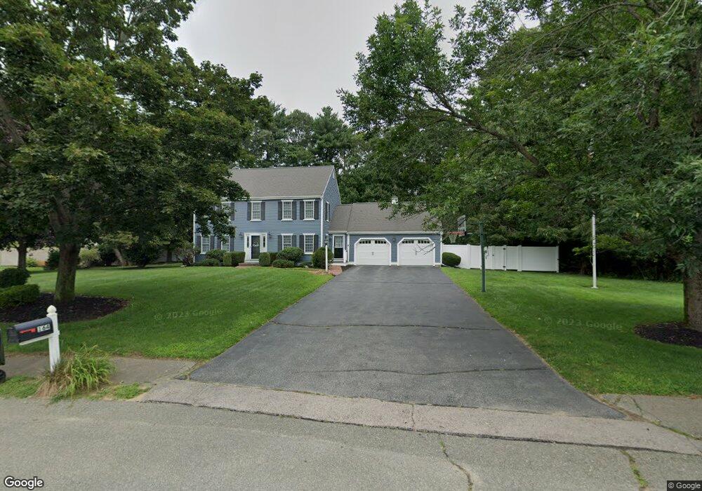
164 Brook Bend Rd Hanson, MA 02341
Estimated Value: $706,000 - $808,000
4
Beds
3
Baths
2,400
Sq Ft
$317/Sq Ft
Est. Value
About This Home
This home is located at 164 Brook Bend Rd, Hanson, MA 02341 and is currently estimated at $761,963, approximately $317 per square foot. 164 Brook Bend Rd is a home located in Plymouth County.
Ownership History
Date
Name
Owned For
Owner Type
Purchase Details
Closed on
Dec 13, 2017
Sold by
Rodri Karen L
Bought by
Karen L Rodri Ft
Current Estimated Value
Purchase Details
Closed on
Nov 16, 2012
Sold by
Rodri Stephen J and Rodri Karen L
Bought by
Rodri Karen L
Purchase Details
Closed on
Aug 24, 2001
Sold by
Estey Rebecca M and Estey Edward J
Bought by
Rodri Stephen J and Rodri Karen L
Purchase Details
Closed on
Mar 1, 1995
Sold by
Levy David M and Levy Johanna
Bought by
Estey Edward J and Estey Rebecca M
Create a Home Valuation Report for This Property
The Home Valuation Report is an in-depth analysis detailing your home's value as well as a comparison with similar homes in the area
Home Values in the Area
Average Home Value in this Area
Purchase History
| Date | Buyer | Sale Price | Title Company |
|---|---|---|---|
| Karen L Rodri Ft | -- | -- | |
| Rodri Karen L | -- | -- | |
| Rodri Stephen J | $365,000 | -- | |
| Estey Edward J | $195,000 | -- |
Source: Public Records
Mortgage History
| Date | Status | Borrower | Loan Amount |
|---|---|---|---|
| Previous Owner | Estey Edward J | $100,000 | |
| Previous Owner | Estey Edward J | $140,500 | |
| Previous Owner | Estey Edward J | $60,000 |
Source: Public Records
Tax History
| Year | Tax Paid | Tax Assessment Tax Assessment Total Assessment is a certain percentage of the fair market value that is determined by local assessors to be the total taxable value of land and additions on the property. | Land | Improvement |
|---|---|---|---|---|
| 2025 | $8,531 | $637,600 | $191,800 | $445,800 |
| 2024 | $8,360 | $624,800 | $186,300 | $438,500 |
| 2023 | $8,080 | $569,800 | $186,300 | $383,500 |
| 2022 | $7,824 | $518,500 | $169,300 | $349,200 |
| 2021 | $7,052 | $467,000 | $162,800 | $304,200 |
| 2020 | $6,955 | $455,500 | $157,300 | $298,200 |
| 2019 | $6,628 | $426,800 | $154,300 | $272,500 |
| 2018 | $4 | $414,200 | $148,400 | $265,800 |
| 2017 | $6,365 | $398,300 | $141,300 | $257,000 |
| 2016 | $6,461 | $390,400 | $141,300 | $249,100 |
| 2015 | $6,120 | $384,400 | $141,300 | $243,100 |
Source: Public Records
Map
Nearby Homes
- 430 Brook Bend Rd
- 339 State St
- 108 Waterford Dr
- 139 Fairwood Dr
- 26 Stonebridge Dr
- 161 Winter St Unit 11
- Lot 5 Princeton Way
- 84 Liberty St
- 127 Crescent Place
- 95 Tecumseh Dr
- 724 Whitman St
- 114 Graham Hill Dr
- 134 Crescent St
- 269 Lakeside Rd
- 51 Farmside Dr
- 51 Cervelli Farm Dr
- 37 Dr
- 23 Cervelli Farm Dr
- 38 Cervelli Farm Dr
- 9 Cervelli Farm Dr
- 168 Brook Bend Rd
- 157 Brook Bend Rd
- 836 E Washington St
- 142 Brook Bend Rd
- 186 Brook Bend Rd
- 824 E Washington St
- 98 Winter Terrace
- 131 Brook Bend Rd
- 850 E Washington St
- 128 Brook Bend Rd
- 84 Winter Terrace
- 204 Brook Bend Rd
- 125 Brook Bend Rd
- 112 Brook Bend Rd
- 66 Winter Terrace
- 87 Winter Terrace
- 288 Brook Bend Rd
- 70 Puritan Dr
- 109 Brook Bend Rd
- 100 Brook Bend Rd
Your Personal Tour Guide
Ask me questions while you tour the home.