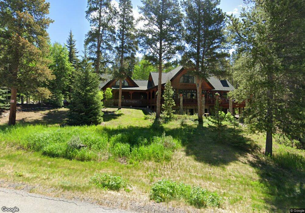
164 Dyer Trail Breckenridge, CO 80424
Estimated Value: $3,833,000 - $4,665,000
4
Beds
4
Baths
3,259
Sq Ft
$1,282/Sq Ft
Est. Value
About This Home
This home is located at 164 Dyer Trail, Breckenridge, CO 80424 and is currently estimated at $4,179,667, approximately $1,282 per square foot. 164 Dyer Trail is a home with nearby schools including Upper Blue Elementary School, Summit Middle School, and Summit High School.
Ownership History
Date
Name
Owned For
Owner Type
Purchase Details
Closed on
Oct 16, 2023
Sold by
Elaine B Collins Colorado House Trust
Bought by
Elaine B Collins Colorado House Trust and Collins
Current Estimated Value
Purchase Details
Closed on
Oct 22, 2013
Sold by
Collins Elaine B
Bought by
Collins Elaine B
Purchase Details
Closed on
Apr 7, 2009
Sold by
Thompson Jerry E and Thompson Victoria P
Bought by
Collins Mike and Collins Elaine
Purchase Details
Closed on
Jul 1, 2005
Sold by
Mckennie William J and Mckennie Rosemary
Bought by
Thompson Jerry E and Thomson Victoria P
Home Financials for this Owner
Home Financials are based on the most recent Mortgage that was taken out on this home.
Original Mortgage
$999,999
Interest Rate
5.06%
Mortgage Type
Adjustable Rate Mortgage/ARM
Create a Home Valuation Report for This Property
The Home Valuation Report is an in-depth analysis detailing your home's value as well as a comparison with similar homes in the area
Home Values in the Area
Average Home Value in this Area
Purchase History
| Date | Buyer | Sale Price | Title Company |
|---|---|---|---|
| Elaine B Collins Colorado House Trust | -- | None Listed On Document | |
| Michael J Collins Colorado House Trust | -- | None Listed On Document | |
| Collins Elaine B | -- | None Available | |
| Collins Michael J | -- | None Available | |
| Collins Michael J | -- | None Available | |
| Collins Mike | $1,500,000 | Title Compny Of The Rockies | |
| Thompson Jerry E | $1,755,000 | None Available |
Source: Public Records
Mortgage History
| Date | Status | Borrower | Loan Amount |
|---|---|---|---|
| Previous Owner | Thompson Jerry E | $999,999 |
Source: Public Records
Tax History Compared to Growth
Tax History
| Year | Tax Paid | Tax Assessment Tax Assessment Total Assessment is a certain percentage of the fair market value that is determined by local assessors to be the total taxable value of land and additions on the property. | Land | Improvement |
|---|---|---|---|---|
| 2024 | $10,519 | $197,529 | -- | -- |
| 2023 | $10,519 | $193,844 | $0 | $0 |
| 2022 | $7,731 | $134,149 | $0 | $0 |
| 2021 | $7,881 | $138,009 | $0 | $0 |
| 2020 | $7,187 | $124,908 | $0 | $0 |
| 2019 | $7,094 | $124,908 | $0 | $0 |
| 2018 | $6,761 | $115,674 | $0 | $0 |
| 2017 | $6,234 | $115,674 | $0 | $0 |
| 2016 | $6,219 | $113,793 | $0 | $0 |
| 2015 | $6,038 | $113,793 | $0 | $0 |
| 2014 | $5,391 | $100,388 | $0 | $0 |
| 2013 | -- | $100,388 | $0 | $0 |
Source: Public Records
Map
Nearby Homes
- 175 Highlands Dr
- 9 Rounds Rd
- 116 Dyer Trail
- 72 Dyer Trail
- 47 Forest Cir
- 74 Western Sky Dr
- 67 Rounds Rd
- 456 Forest Hills Dr
- 32 Magnum Bonum Dr
- 24 Magnum Bonum Dr
- 847 Airport Rd Unit 24
- 847 Airport Rd Unit 12
- 847 Airport Rd Unit 18
- 847 Airport Rd Unit 4
- 847 Airport Rd Unit 21
- 847 Airport Rd
- 150 Lunar Ln
- 3 Barney Ford Dr
- 132 Reiling Rd
- 114 Luisa Dr