Estimated Value: $783,163 - $1,058,000
4
Beds
3
Baths
2,248
Sq Ft
$387/Sq Ft
Est. Value
About This Home
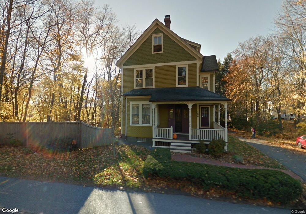
This home is located at 164 Main St, Acton, MA 01720 and is currently estimated at $870,541, approximately $387 per square foot. 164 Main St is a home located in Middlesex County with nearby schools including Acton-Boxborough Regional High School, Maynard Knowledge Beginnings, and The Imago School.
Ownership History
Date
Name
Owned For
Owner Type
Purchase Details
Closed on
Aug 11, 1999
Sold by
Wentling Karen L and Wentling Jeffrey C
Bought by
Dwyer Carol A and Landers Franklin M
Current Estimated Value
Home Financials for this Owner
Home Financials are based on the most recent Mortgage that was taken out on this home.
Original Mortgage
$272,560
Outstanding Balance
$78,324
Interest Rate
7.65%
Mortgage Type
Purchase Money Mortgage
Estimated Equity
$792,217
Purchase Details
Closed on
Jan 6, 1989
Sold by
March Frederick
Bought by
Lorentsen C Roy
Create a Home Valuation Report for This Property
The Home Valuation Report is an in-depth analysis detailing your home's value as well as a comparison with similar homes in the area
Home Values in the Area
Average Home Value in this Area
Purchase History
| Date | Buyer | Sale Price | Title Company |
|---|---|---|---|
| Dwyer Carol A | $340,700 | -- | |
| Lorentsen C Roy | $175,000 | -- |
Source: Public Records
Mortgage History
| Date | Status | Borrower | Loan Amount |
|---|---|---|---|
| Open | Lorentsen C Roy | $135,000 | |
| Open | Lorentsen C Roy | $272,560 | |
| Previous Owner | Lorentsen C Roy | $200,000 |
Source: Public Records
Tax History
| Year | Tax Paid | Tax Assessment Tax Assessment Total Assessment is a certain percentage of the fair market value that is determined by local assessors to be the total taxable value of land and additions on the property. | Land | Improvement |
|---|---|---|---|---|
| 2025 | $10,395 | $606,100 | $269,800 | $336,300 |
| 2024 | $10,110 | $606,500 | $269,800 | $336,700 |
| 2023 | $10,004 | $569,700 | $245,300 | $324,400 |
| 2022 | $9,639 | $495,600 | $213,200 | $282,400 |
| 2021 | $9,318 | $460,600 | $197,500 | $263,100 |
| 2020 | $8,964 | $465,900 | $197,500 | $268,400 |
| 2019 | $8,449 | $436,200 | $197,500 | $238,700 |
| 2018 | $8,525 | $439,900 | $197,500 | $242,400 |
| 2017 | $8,211 | $430,800 | $197,500 | $233,300 |
| 2016 | $7,927 | $412,200 | $197,500 | $214,700 |
| 2015 | $7,557 | $396,700 | $187,600 | $209,100 |
| 2014 | $7,576 | $389,500 | $197,500 | $192,000 |
Source: Public Records
Map
Nearby Homes
- 184 Main St Unit 3
- 25 Nylander Way
- 129 Main St Unit 129
- 131 Main St
- 7 Kelley Rd
- 246 Main St Unit 2
- 40 High St
- 70 River St
- 30 Brewster Ln
- 1 Vanderbelt Rd
- 7 Hillcrest Dr
- 90 Willow St Unit 1
- 92 Willow St Unit 3
- 92 Willow St Unit 2
- 20 Joseph Reed Ln
- 235 Arlington St
- 63 Conant St
- 18 Hayward Rd
- 128 Parker St Unit 3B
- 46 Taylor Rd
Your Personal Tour Guide
Ask me questions while you tour the home.