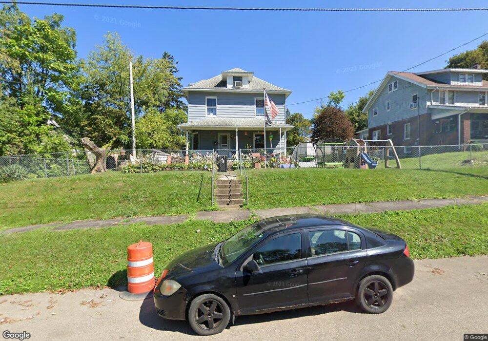
164 Rae Ave Mansfield, OH 44903
Estimated Value: $61,000 - $85,089
3
Beds
1
Bath
1,716
Sq Ft
$42/Sq Ft
Est. Value
About This Home
This home is located at 164 Rae Ave, Mansfield, OH 44903 and is currently estimated at $71,772, approximately $41 per square foot. 164 Rae Ave is a home located in Richland County with nearby schools including Goal Digital Academy, Mansfield Elective Academy, and Interactive Media & Construction (IMAC) Academy.
Ownership History
Date
Name
Owned For
Owner Type
Purchase Details
Closed on
Feb 28, 2006
Sold by
Crone Crystal
Bought by
Dennison Gary Lee
Current Estimated Value
Purchase Details
Closed on
Aug 14, 2003
Sold by
Gamble Mack A
Bought by
Smith Waitman E and Smith Brenda K
Purchase Details
Closed on
Apr 21, 1995
Sold by
Davis Richard W
Bought by
Gamble Mack A and Gamble Grace
Home Financials for this Owner
Home Financials are based on the most recent Mortgage that was taken out on this home.
Original Mortgage
$25,600
Interest Rate
8.64%
Mortgage Type
New Conventional
Purchase Details
Closed on
May 8, 1991
Sold by
Davis Richard W
Bought by
Davis Richard W
Create a Home Valuation Report for This Property
The Home Valuation Report is an in-depth analysis detailing your home's value as well as a comparison with similar homes in the area
Home Values in the Area
Average Home Value in this Area
Purchase History
| Date | Buyer | Sale Price | Title Company |
|---|---|---|---|
| Dennison Gary Lee | -- | None Available | |
| Dennison Gary Lee | -- | None Available | |
| Smith Waitman E | $16,500 | -- | |
| Gamble Mack A | $25,000 | -- | |
| Davis Richard W | -- | -- |
Source: Public Records
Mortgage History
| Date | Status | Borrower | Loan Amount |
|---|---|---|---|
| Previous Owner | Gamble Mack A | $25,600 |
Source: Public Records
Tax History Compared to Growth
Tax History
| Year | Tax Paid | Tax Assessment Tax Assessment Total Assessment is a certain percentage of the fair market value that is determined by local assessors to be the total taxable value of land and additions on the property. | Land | Improvement |
|---|---|---|---|---|
| 2024 | $731 | $15,270 | $2,100 | $13,170 |
| 2023 | $731 | $15,270 | $2,100 | $13,170 |
| 2022 | $572 | $10,010 | $2,030 | $7,980 |
| 2021 | $576 | $10,010 | $2,030 | $7,980 |
| 2020 | $589 | $10,010 | $2,030 | $7,980 |
| 2019 | $653 | $10,010 | $2,030 | $7,980 |
| 2018 | $644 | $10,010 | $2,030 | $7,980 |
| 2017 | $703 | $10,010 | $2,030 | $7,980 |
| 2016 | $778 | $12,050 | $4,740 | $7,310 |
| 2015 | $778 | $12,050 | $4,740 | $7,310 |
| 2014 | $733 | $12,050 | $4,740 | $7,310 |
| 2012 | $281 | $12,050 | $4,990 | $7,060 |
Source: Public Records
Map
Nearby Homes
- 96 Helen Ave
- 237 Helen Ave
- 80 Rowland Ave
- 120 Gettings Place
- 116 Penn Ave
- 611 Park Ave W
- 406 Sherman Place
- 24 Stewart Ave S
- 21 Glenwood Blvd
- 41 Parkwood Blvd
- 132 Sycamore St
- 38 Baldwin Ave
- 71 Glenwood Blvd
- 37 Baldwin Ave
- 88 Sherman Ave
- 76 Bartley Ave
- 126 Dawson Ave
- 118 Parkwood Blvd
- 114 Vennum Ave
- 118 Lind Ave