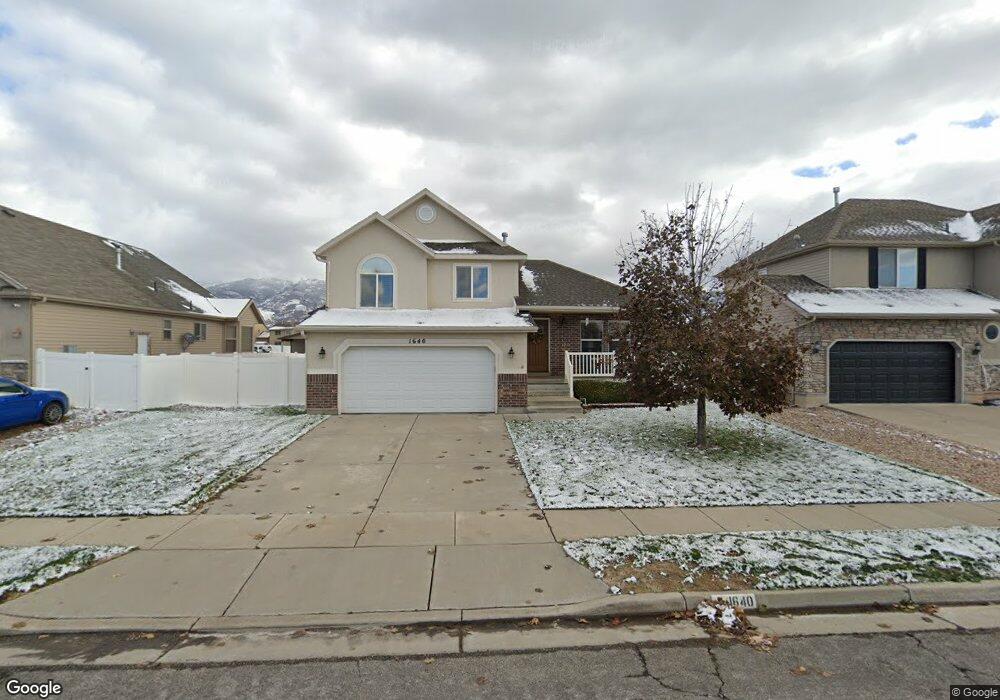
1640 N 125 W Layton, UT 84041
Estimated Value: $462,180 - $494,000
3
Beds
2
Baths
1,364
Sq Ft
$354/Sq Ft
Est. Value
About This Home
This home is located at 1640 N 125 W, Layton, UT 84041 and is currently estimated at $482,295, approximately $353 per square foot. 1640 N 125 W is a home located in Davis County with nearby schools including Lincoln Elementary School, North Layton Junior High School, and Northridge High School.
Ownership History
Date
Name
Owned For
Owner Type
Purchase Details
Closed on
Jun 10, 2024
Sold by
Balboa Ricardo E and Balboa Viviana L
Bought by
Rl Balboa Martinez Family Trust and Balboa-Contreras
Current Estimated Value
Purchase Details
Closed on
Aug 25, 2005
Sold by
North Ivory
Bought by
Balboa Ricardo E and Balboa Viviana L
Home Financials for this Owner
Home Financials are based on the most recent Mortgage that was taken out on this home.
Original Mortgage
$9,579
Interest Rate
5.61%
Mortgage Type
Stand Alone Second
Create a Home Valuation Report for This Property
The Home Valuation Report is an in-depth analysis detailing your home's value as well as a comparison with similar homes in the area
Home Values in the Area
Average Home Value in this Area
Purchase History
| Date | Buyer | Sale Price | Title Company |
|---|---|---|---|
| Rl Balboa Martinez Family Trust | -- | None Listed On Document | |
| Balboa Ricardo E | -- | Cottonwood Title Ins Agency |
Source: Public Records
Mortgage History
| Date | Status | Borrower | Loan Amount |
|---|---|---|---|
| Previous Owner | Balboa Ricardo E | $9,579 | |
| Previous Owner | Balboa Ricardo E | $169,494 |
Source: Public Records
Tax History Compared to Growth
Tax History
| Year | Tax Paid | Tax Assessment Tax Assessment Total Assessment is a certain percentage of the fair market value that is determined by local assessors to be the total taxable value of land and additions on the property. | Land | Improvement |
|---|---|---|---|---|
| 2025 | $2,363 | $248,050 | $89,910 | $158,140 |
| 2024 | $2,263 | $239,250 | $105,447 | $133,803 |
| 2023 | $2,329 | $434,000 | $131,892 | $302,108 |
| 2022 | $2,375 | $240,350 | $67,764 | $172,586 |
| 2021 | $2,153 | $325,000 | $90,054 | $234,946 |
| 2020 | $1,933 | $280,000 | $77,849 | $202,151 |
| 2019 | $1,890 | $268,000 | $75,880 | $192,120 |
| 2018 | $1,721 | $245,000 | $75,880 | $169,120 |
| 2016 | $1,531 | $112,475 | $22,884 | $89,591 |
| 2015 | $1,553 | $108,295 | $22,884 | $85,411 |
| 2014 | $1,545 | $110,134 | $22,884 | $87,250 |
| 2013 | -- | $109,679 | $31,103 | $78,576 |
Source: Public Records
Map
Nearby Homes