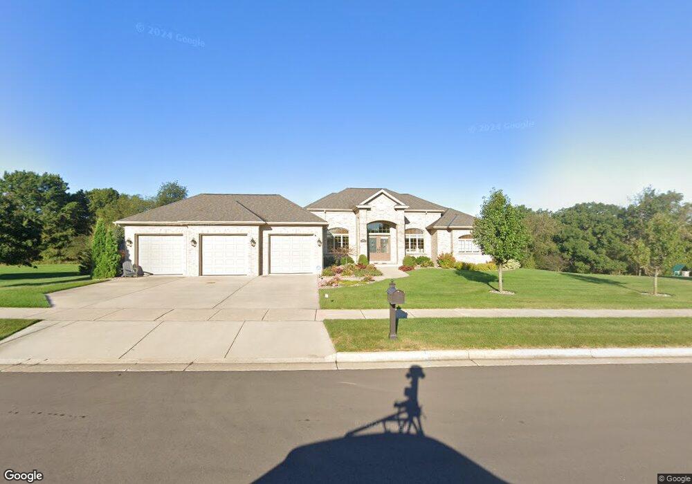
1641 Pearson Ct Whitewater, WI 53190
Estimated Value: $533,000 - $722,000
3
Beds
3
Baths
3,358
Sq Ft
$198/Sq Ft
Est. Value
About This Home
This home is located at 1641 Pearson Ct, Whitewater, WI 53190 and is currently estimated at $665,084, approximately $198 per square foot. 1641 Pearson Ct is a home located in Walworth County with nearby schools including Whitewater High School and Kettle Moraine Baptist Academy.
Ownership History
Date
Name
Owned For
Owner Type
Purchase Details
Closed on
Mar 2, 2007
Sold by
Ehlert Scott G
Bought by
Davenport Michael C and Davenport Pok Ye
Current Estimated Value
Home Financials for this Owner
Home Financials are based on the most recent Mortgage that was taken out on this home.
Original Mortgage
$59,400
Outstanding Balance
$35,974
Interest Rate
6.27%
Mortgage Type
Future Advance Clause Open End Mortgage
Estimated Equity
$629,110
Create a Home Valuation Report for This Property
The Home Valuation Report is an in-depth analysis detailing your home's value as well as a comparison with similar homes in the area
Home Values in the Area
Average Home Value in this Area
Purchase History
| Date | Buyer | Sale Price | Title Company |
|---|---|---|---|
| Davenport Michael C | $84,900 | None Available |
Source: Public Records
Mortgage History
| Date | Status | Borrower | Loan Amount |
|---|---|---|---|
| Open | Davenport Michael C | $59,400 |
Source: Public Records
Tax History Compared to Growth
Tax History
| Year | Tax Paid | Tax Assessment Tax Assessment Total Assessment is a certain percentage of the fair market value that is determined by local assessors to be the total taxable value of land and additions on the property. | Land | Improvement |
|---|---|---|---|---|
| 2024 | $9,988 | $673,100 | $66,900 | $606,200 |
| 2023 | $9,526 | $600,000 | $66,900 | $533,100 |
| 2022 | $10,602 | $599,900 | $66,900 | $533,000 |
| 2021 | $13,698 | $681,900 | $66,900 | $615,000 |
| 2020 | $12,553 | $617,900 | $66,900 | $551,000 |
| 2019 | $11,324 | $553,800 | $66,900 | $486,900 |
| 2018 | $10,972 | $537,100 | $66,900 | $470,200 |
| 2017 | $10,294 | $517,800 | $66,900 | $450,900 |
| 2016 | $10,495 | $510,000 | $66,900 | $443,100 |
| 2015 | $10,505 | $510,000 | $66,900 | $443,100 |
| 2014 | $10,452 | $483,000 | $66,900 | $416,100 |
| 2013 | $10,452 | $483,000 | $66,900 | $416,100 |
Source: Public Records
Map
Nearby Homes
- Lt10 Pearson Ct
- The Basswood Duplex Plan at The Residences at Meadowview
- The Magnolia Duplex Plan at The Residences at Meadowview
- The Spruce Ranch Duplex Plan at The Residences at Meadowview
- 1591 Meadowview Ct
- 1581 Meadowview Ct
- 255 Indian Mound Pkwy
- 1584 Meadowview Ct
- 1589 Meadowview Ct
- 1575 Meadowview Ct
- Lt1 Warner Rd
- 1639 Turtle Mound Ln
- 215 S Pine Cir
- 421 Indian Mound Pkwy
- 1252 W Laurel St
- 695 Stonefield Ln
- 680 Stonefield Ln
- 1270 Black River Ct
- 1139 W Highland St
- 1229 W Bloomingfield Dr
- Lt5 Pearson Ct Unit Lt5
- 1631 Pearson Ct
- Lt10 Pearson Ct Unit Lt10
- 1621 Pearson Ct
- 1515 W Main St
- W9589 Breidsan Dr
- W9597 Breidsan Dr
- W9609 Breidsan Dr
- W9619 Breidsan Dr
- W9600 Breidsan Dr
- W9580 Breidsan Dr
- W9625 Breidsan Dr
- W9618 Breidsan Dr
- part of 1461 W Main
- N9637 Old Highway 12
- W9629 Breidsan Dr
- L21 Hwy 12
- W9622 Breidsan Dr
- W9667 Homburg Ln
- W9665 Homburg Ln