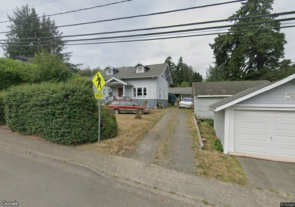
1641 Southwest Blvd Coos Bay, OR 97420
Estimated Value: $320,000 - $321,531
4
Beds
1
Bath
1,336
Sq Ft
$240/Sq Ft
Est. Value
About This Home
This home is located at 1641 Southwest Blvd, Coos Bay, OR 97420 and is currently estimated at $320,766, approximately $240 per square foot. 1641 Southwest Blvd is a home located in Coos County with nearby schools including Eastside School, Millicoma School, and Marshfield Senior High School.
Ownership History
Date
Name
Owned For
Owner Type
Purchase Details
Closed on
May 23, 2023
Sold by
Snyder Raymond P and Snyder Gail A
Bought by
Raymond P Snyder And Gail A Snyder Revocable and Snyder
Current Estimated Value
Purchase Details
Closed on
Jun 16, 2010
Sold by
Hathorn Frederick C and Wettestead Linda
Bought by
Snyder Raymond P and Snyder Gail A
Home Financials for this Owner
Home Financials are based on the most recent Mortgage that was taken out on this home.
Original Mortgage
$124,000
Interest Rate
4.99%
Mortgage Type
New Conventional
Create a Home Valuation Report for This Property
The Home Valuation Report is an in-depth analysis detailing your home's value as well as a comparison with similar homes in the area
Home Values in the Area
Average Home Value in this Area
Purchase History
| Date | Buyer | Sale Price | Title Company |
|---|---|---|---|
| Raymond P Snyder And Gail A Snyder Revocable | -- | None Listed On Document | |
| Snyder Raymond P | $155,000 | Fidelity National Title Co |
Source: Public Records
Mortgage History
| Date | Status | Borrower | Loan Amount |
|---|---|---|---|
| Previous Owner | Snyder Raymond P | $124,000 |
Source: Public Records
Tax History Compared to Growth
Tax History
| Year | Tax Paid | Tax Assessment Tax Assessment Total Assessment is a certain percentage of the fair market value that is determined by local assessors to be the total taxable value of land and additions on the property. | Land | Improvement |
|---|---|---|---|---|
| 2024 | $2,295 | $132,060 | -- | -- |
| 2023 | $2,226 | $128,220 | $0 | $0 |
| 2022 | $2,190 | $124,490 | $0 | $0 |
| 2021 | $2,133 | $120,870 | $0 | $0 |
| 2020 | $2,073 | $120,870 | $0 | $0 |
| 2019 | $1,990 | $113,940 | $0 | $0 |
| 2018 | $1,922 | $110,630 | $0 | $0 |
| 2017 | $1,703 | $107,410 | $0 | $0 |
| 2016 | $1,626 | $104,290 | $0 | $0 |
| 2015 | $1,515 | $101,260 | $0 | $0 |
| 2014 | $1,515 | $98,320 | $0 | $0 |
Source: Public Records
Map
Nearby Homes
- 1123 Oregon Ave
- 1138 Oregon Ave
- 1169 Washington Ave
- 1194 Oregon Ave
- 1351 Dakota St
- 1348 Dakota Ave
- 0 California Ave
- 0 Graham St Unit 546213972
- 93195 Coal Bank Ln
- 0 Minnesota
- 766 Southwest Blvd
- 0 Pennsylvania Ave Unit 23250131
- 2250 S 17th St
- 1050 S 8th St
- 0 Miriam Unit 740433342
- 0 Idaho Dr Unit 300 21226511
- 0 Johnson Ave
- 1300 Ingersoll St
- 1395 Ingersoll St
- 1032 S 4th St
- 1641 Southwestern Bv
- 1657 Southwest Blvd
- 1133 Oregon Ave
- 1695 Southwest Blvd
- 1646 Southwest Blvd
- 1126 California Ave
- 1132 California Ave
- 1594 Southwest Blvd
- 1094 California Ave
- 1586 Southwest Blvd
- 1149 Oregon Ave
- 1068 California Ave
- 1138 California Ave
- 1525 Southwest Blvd
- 1148 Oregon Ave
- 1719 Southwest Blvd
- 1111 Washington Ave
- 1525 Southwestern Bv Blvd
- 1165 Oregon Ave
- 1115 Washington Ave