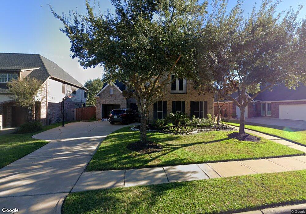
16411 Burham Park Dr Cypress, TX 77429
Estimated Value: $603,000 - $627,000
4
Beds
4
Baths
3,875
Sq Ft
$159/Sq Ft
Est. Value
About This Home
This home is located at 16411 Burham Park Dr, Cypress, TX 77429 and is currently estimated at $614,587, approximately $158 per square foot. 16411 Burham Park Dr is a home located in Harris County with nearby schools including Sampson Elementary School, Spillane Middle School, and Cypress Woods High School.
Ownership History
Date
Name
Owned For
Owner Type
Purchase Details
Closed on
Jun 6, 2022
Sold by
Michael Gerl Jeffrey
Bought by
Gerl Tracey Brewer
Current Estimated Value
Purchase Details
Closed on
Aug 26, 2011
Sold by
Cartus Financial Corporation
Bought by
Gerl Jeffrey M and Gerl Tracey B
Home Financials for this Owner
Home Financials are based on the most recent Mortgage that was taken out on this home.
Original Mortgage
$258,282
Interest Rate
4.37%
Mortgage Type
FHA
Purchase Details
Closed on
Jul 14, 2010
Sold by
Villoria Carlos M and Burgazzi Consuelo C
Bought by
Shulkin Leonid B and Shulkin Tatyana E
Home Financials for this Owner
Home Financials are based on the most recent Mortgage that was taken out on this home.
Original Mortgage
$145,000
Interest Rate
3%
Mortgage Type
VA
Purchase Details
Closed on
Nov 15, 2007
Sold by
Mitchell Phillip Thomas and Mitchell Elizabeth Helen
Bought by
Villoria Carlos M and Burgazzi Consuelo C
Home Financials for this Owner
Home Financials are based on the most recent Mortgage that was taken out on this home.
Original Mortgage
$232,000
Interest Rate
6.38%
Mortgage Type
Purchase Money Mortgage
Purchase Details
Closed on
Jun 29, 2006
Sold by
Keal James T and Keal Bridget E
Bought by
Mitchell Phillip Thomas and Mitchell Elizabeth Helen
Home Financials for this Owner
Home Financials are based on the most recent Mortgage that was taken out on this home.
Original Mortgage
$210,000
Interest Rate
6.58%
Mortgage Type
Purchase Money Mortgage
Purchase Details
Closed on
Mar 18, 2005
Sold by
Mumford Blair D and Mumford Jeri Wynn Gillie
Bought by
Keal James T and Keal Bridget E
Home Financials for this Owner
Home Financials are based on the most recent Mortgage that was taken out on this home.
Original Mortgage
$191,500
Interest Rate
5.67%
Mortgage Type
Purchase Money Mortgage
Purchase Details
Closed on
Oct 24, 2001
Sold by
Newmark Homes Lp
Bought by
Mumford Blair D and Mumford Jeri Wyn Gillie
Home Financials for this Owner
Home Financials are based on the most recent Mortgage that was taken out on this home.
Original Mortgage
$238,378
Interest Rate
6.84%
Create a Home Valuation Report for This Property
The Home Valuation Report is an in-depth analysis detailing your home's value as well as a comparison with similar homes in the area
Home Values in the Area
Average Home Value in this Area
Purchase History
| Date | Buyer | Sale Price | Title Company |
|---|---|---|---|
| Gerl Tracey Brewer | $295,000 | None Listed On Document | |
| Gerl Jeffrey M | -- | Texas American Title Company | |
| Shulkin Leonid B | -- | Startex Title Company | |
| Villoria Carlos M | -- | Guardian Fidelity Title | |
| Mitchell Phillip Thomas | -- | Startex Title Company | |
| Keal James T | -- | Chicago Title Insurance Comp | |
| Mumford Blair D | -- | Pacific Title Lc |
Source: Public Records
Mortgage History
| Date | Status | Borrower | Loan Amount |
|---|---|---|---|
| Previous Owner | Gerl Jeffrey M | $258,282 | |
| Previous Owner | Shulkin Leonid B | $145,000 | |
| Previous Owner | Villoria Carlos M | $232,000 | |
| Previous Owner | Mitchell Phillip Thomas | $210,000 | |
| Previous Owner | Keal James T | $191,500 | |
| Previous Owner | Mumford Blair D | $238,378 |
Source: Public Records
Tax History Compared to Growth
Tax History
| Year | Tax Paid | Tax Assessment Tax Assessment Total Assessment is a certain percentage of the fair market value that is determined by local assessors to be the total taxable value of land and additions on the property. | Land | Improvement |
|---|---|---|---|---|
| 2025 | $9,313 | $565,778 | $103,530 | $462,248 |
| 2024 | $9,313 | $564,289 | $94,159 | $470,130 |
| 2023 | $9,313 | $575,405 | $94,159 | $481,246 |
| 2022 | $10,761 | $514,177 | $67,384 | $446,793 |
| 2021 | $10,366 | $409,382 | $67,384 | $341,998 |
| 2020 | $9,732 | $370,851 | $49,739 | $321,112 |
| 2019 | $9,942 | $367,464 | $49,739 | $317,725 |
| 2018 | $3,873 | $367,464 | $49,739 | $317,725 |
| 2017 | $9,981 | $367,464 | $49,739 | $317,725 |
| 2016 | $9,981 | $367,464 | $49,739 | $317,725 |
| 2015 | $7,299 | $367,464 | $49,739 | $317,725 |
| 2014 | $7,299 | $324,017 | $49,739 | $274,278 |
Source: Public Records
Map
Nearby Homes
- 14015 Halprin Creek Dr
- 14015 Falcon Heights Dr
- 16211 Halpren Falls Ln
- 13703 Layton Hills Dr
- 16342 Granite Park Ct
- 16406 Haden Crest Ct
- 15902 Mill Canyon Ct
- 16219 Haden Crest Ct
- 16306 Bontura St
- 16322 Bontura St
- 14207 Spindle Arbor Rd
- 13611 Monteigne Ln
- 14126 Bloomingdale Manor Dr
- 16606 Darby House St
- 13506 Key Ridge Ln
- 16131 Cypress Point Dr
- 16515 Dunleith Cir
- 13718 Sherburn Manor Dr
- 16302 Cypress Point Dr
- 13402 Layton Castle Ln
- 16407 Burham Park Dr
- 16415 Burham Park Dr
- 16403 Burham Park Dr
- 13902 Falcon Heights Dr
- 16327 Burham Park Dr
- 16402 Burham Park Dr
- 13906 Falcon Heights Dr
- 13903 Falcon Heights Dr
- 16330 Burham Park Dr
- 16322 Destrehan Dr
- 13907 Falcon Heights Dr
- 16318 Destrehan Dr
- 16326 Destrehan Dr
- 16326 Burham Park Dr
- 16314 Destrehan Dr
- 16407 Mahogany Crest Dr
- 13910 Falcon Heights Dr
- 13822 Greenwood Manor Dr
- 16319 Burham Park Dr
- 16310 Destrehan Dr