Estimated Value: $450,085 - $506,000
4
Beds
3
Baths
2,464
Sq Ft
$194/Sq Ft
Est. Value
About This Home
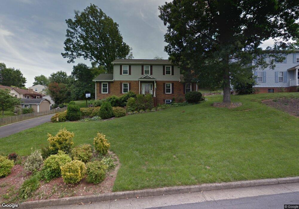
This home is located at 1646 Millbridge Rd, Salem, VA 24153 and is currently estimated at $477,271, approximately $193 per square foot. 1646 Millbridge Rd is a home located in Roanoke County with nearby schools including Fort Lewis Elementary School, Glenvar Middle School, and Glenvar High School.
Ownership History
Date
Name
Owned For
Owner Type
Purchase Details
Closed on
Apr 14, 2021
Sold by
Wilkes Kirk W
Bought by
Wilkes Kirk W and Wilkes Jeanne D
Current Estimated Value
Purchase Details
Closed on
Nov 12, 2019
Sold by
Wilkes Kirk W and Wilkes Deidre
Bought by
Wilkes Kirk W
Home Financials for this Owner
Home Financials are based on the most recent Mortgage that was taken out on this home.
Original Mortgage
$60,000
Outstanding Balance
$52,265
Interest Rate
3.65%
Mortgage Type
Credit Line Revolving
Estimated Equity
$425,006
Purchase Details
Closed on
Jun 15, 2007
Sold by
Crotts George Dale
Bought by
Wilkes Kirk W and Wilkes Deidre
Home Financials for this Owner
Home Financials are based on the most recent Mortgage that was taken out on this home.
Original Mortgage
$231,960
Outstanding Balance
$139,849
Interest Rate
6.37%
Mortgage Type
New Conventional
Estimated Equity
$337,422
Create a Home Valuation Report for This Property
The Home Valuation Report is an in-depth analysis detailing your home's value as well as a comparison with similar homes in the area
Purchase History
| Date | Buyer | Sale Price | Title Company |
|---|---|---|---|
| Wilkes Kirk W | -- | Sage Title Group Llc | |
| Wilkes Kirk W | -- | None Available | |
| Wilkes Kirk W | $289,000 | None Available |
Source: Public Records
Mortgage History
| Date | Status | Borrower | Loan Amount |
|---|---|---|---|
| Open | Wilkes Kirk W | $60,000 | |
| Open | Wilkes Kirk W | $231,960 |
Source: Public Records
Tax History
| Year | Tax Paid | Tax Assessment Tax Assessment Total Assessment is a certain percentage of the fair market value that is determined by local assessors to be the total taxable value of land and additions on the property. | Land | Improvement |
|---|---|---|---|---|
| 2025 | $3,912 | $379,800 | $64,000 | $315,800 |
| 2024 | $3,525 | $338,900 | $61,000 | $277,900 |
| 2023 | $3,342 | $315,300 | $61,000 | $254,300 |
| 2022 | $3,243 | $297,500 | $59,000 | $238,500 |
| 2021 | $3,002 | $275,400 | $54,000 | $221,400 |
| 2020 | $2,907 | $266,700 | $50,000 | $216,700 |
| 2019 | $2,855 | $261,900 | $50,000 | $211,900 |
| 2018 | $2,752 | $253,500 | $46,000 | $207,500 |
| 2017 | $2,752 | $252,500 | $46,000 | $206,500 |
| 2016 | $2,726 | $250,100 | $46,000 | $204,100 |
| 2015 | $2,728 | $250,300 | $46,000 | $204,300 |
| 2014 | $2,720 | $249,500 | $45,000 | $204,500 |
Source: Public Records
Map
Nearby Homes
- 2120 River Oaks Dr
- 2158 River Oaks Dr
- 1633 Millwood Dr
- 2287 Foxfield Ln
- Lot 6 Om Ln
- 1744 High Gate Ln
- 1818 High Gate Ln
- 3086 Isabel Ln
- 3076 Isabel Ln
- 2356 W Riverside Dr
- 2816 Russlen Dr
- 2824 Russlen Dr
- 2812 Russlen Dr
- 2808 Russlen Dr
- 2804 Russlen Dr
- 2821 Russlen Dr
- 2813 Russlen Dr
- 2817 Russlen Dr
- 2825 Russlen Dr
- 2829 Russlen Dr
- 1650 Millbridge Rd
- 1915 Queensmill Dr
- 1921 Queensmill Dr
- 2015 Stone Mill Dr
- 2019 Stone Mill Dr
- 1929 Queensmill Dr
- 1654 Millbridge Rd
- 1647 Millbridge Rd
- 1909 Queensmill Dr
- 1651 Millbridge Rd
- 2023 Stone Mill Dr
- 1935 Queensmill Dr
- 1655 Millbridge Rd
- 1658 Millbridge Rd
- 1910 Queensmill Dr
- 1912 Queensmill Dr
- 2029 Stone Mill Dr
- 1908 Queensmill Dr
- 1916 Queensmill Dr
- 2018 Stone Mill Dr
Your Personal Tour Guide
Ask me questions while you tour the home.