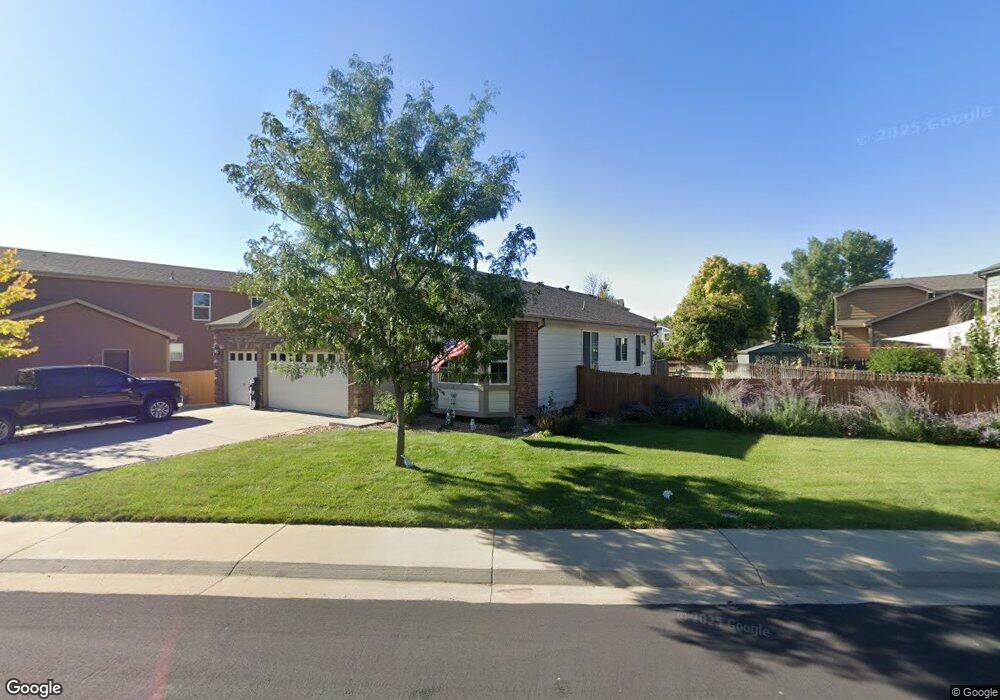
1648 E 131st Cir Thornton, CO 80241
Hunters Glen NeighborhoodEstimated Value: $548,655 - $597,000
3
Beds
2
Baths
2,436
Sq Ft
$236/Sq Ft
Est. Value
About This Home
This home is located at 1648 E 131st Cir, Thornton, CO 80241 and is currently estimated at $574,414, approximately $235 per square foot. 1648 E 131st Cir is a home located in Adams County with nearby schools including Hunters Glen Elementary School, Century Middle School, and Mountain Range High School.
Ownership History
Date
Name
Owned For
Owner Type
Purchase Details
Closed on
Jan 9, 2026
Sold by
Hillard Donald and Hillard Mary
Bought by
Donald W Hillard Living Trust and Mary O Hillard Living Trust
Current Estimated Value
Purchase Details
Closed on
Aug 20, 2019
Sold by
Conner Irene F
Bought by
Hillard Donald and Hillard Mary
Home Financials for this Owner
Home Financials are based on the most recent Mortgage that was taken out on this home.
Original Mortgage
$373,500
Interest Rate
3.6%
Mortgage Type
New Conventional
Purchase Details
Closed on
May 28, 2004
Sold by
Murphy Kevin J and Freyta Cynthia L
Bought by
Conner Alfred P and Conner Irene F
Purchase Details
Closed on
Oct 15, 1998
Sold by
Kdb Homes Inc
Bought by
Murphy Kevin J and Freyta Cynthia L
Home Financials for this Owner
Home Financials are based on the most recent Mortgage that was taken out on this home.
Original Mortgage
$149,350
Interest Rate
6.73%
Create a Home Valuation Report for This Property
The Home Valuation Report is an in-depth analysis detailing your home's value as well as a comparison with similar homes in the area
Home Values in the Area
Average Home Value in this Area
Purchase History
| Date | Buyer | Sale Price | Title Company |
|---|---|---|---|
| Donald W Hillard Living Trust | -- | None Listed On Document | |
| Hillard Donald | $415,000 | Homestead Title & Escrow | |
| Conner Alfred P | $252,000 | Fahtco | |
| Murphy Kevin J | $165,980 | -- |
Source: Public Records
Mortgage History
| Date | Status | Borrower | Loan Amount |
|---|---|---|---|
| Previous Owner | Hillard Donald | $373,500 | |
| Previous Owner | Murphy Kevin J | $149,350 |
Source: Public Records
Tax History
| Year | Tax Paid | Tax Assessment Tax Assessment Total Assessment is a certain percentage of the fair market value that is determined by local assessors to be the total taxable value of land and additions on the property. | Land | Improvement |
|---|---|---|---|---|
| 2025 | $3,774 | $37,810 | $8,500 | $29,310 |
| 2024 | $3,774 | $34,750 | $7,810 | $26,940 |
| 2023 | $3,736 | $40,180 | $7,100 | $33,080 |
| 2022 | $3,098 | $28,120 | $7,300 | $20,820 |
| 2021 | $3,200 | $28,120 | $7,300 | $20,820 |
| 2020 | $2,324 | $27,980 | $7,510 | $20,470 |
| 2019 | $2,328 | $27,980 | $7,510 | $20,470 |
| 2018 | $1,884 | $23,570 | $7,490 | $16,080 |
| 2017 | $1,713 | $23,570 | $7,490 | $16,080 |
| 2016 | $1,339 | $20,420 | $5,170 | $15,250 |
| 2015 | $1,337 | $12,470 | $3,160 | $9,310 |
| 2014 | $1,989 | $17,240 | $3,580 | $13,660 |
Source: Public Records
Map
Nearby Homes
- 1672 E 131st Ct
- 7 Sandpiper Cir
- 2066 E 129th Ave
- 1162 E 130th Ave Unit B
- 12885 Vine St
- 12905 Lafayette St Unit H
- 1174 E 130th Dr
- 58 Blue Heron Dr
- 2263 E 129th Ave Unit 2263
- 2275 E 129th Ave
- 13508 Vine St
- 2297 E 128th Ave
- 13322 Columbine Cir
- 1960 E 135th Place
- 2746 E 132nd Place
- 2945 E 135th Place
- 2942 E 135th Place
- 13406 Clayton St
- 2973 E 133rd Ln
- 12560 Josephine St
- 1642 E 131st Cir
- 1654 E 131st Ct
- 1660 E 131st Ct
- 1649 E 131st Cir
- 1645 E 131st Cir
- 1651 E 131st Cir
- 1641 E 131st Cir
- 1655 E 131st Cir
- 1632 E 131st Cir
- 1668 E 131st Ct
- 1659 E 131st Cir
- 1639 E 131st Cir
- 1629 E 131st Cir
- 1626 E 131st Cir
- 1625 E 131st Cir
- 13068 Race Ct
- 1631 E 131st Cir
- 1620 E 131st Cir
- 13078 Race Ct
- 1661 E 131st Cir
Your Personal Tour Guide
Ask me questions while you tour the home.