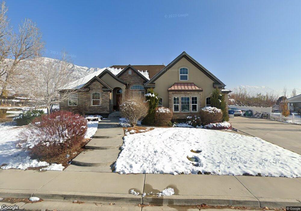
1648 Leslie Cir Pleasant Grove, UT 84062
Estimated Value: $763,000 - $989,425
3
Beds
3
Baths
2,840
Sq Ft
$321/Sq Ft
Est. Value
About This Home
This home is located at 1648 Leslie Cir, Pleasant Grove, UT 84062 and is currently estimated at $911,356, approximately $320 per square foot. 1648 Leslie Cir is a home located in Utah County with nearby schools including Mount Mahogany School, Pleasant Grove Junior High School, and Pleasant Grove High School.
Ownership History
Date
Name
Owned For
Owner Type
Purchase Details
Closed on
Jan 5, 2007
Sold by
Bishop Andrew
Bought by
Shirley Rad K and Shirley Gwendolyn Eastman
Current Estimated Value
Purchase Details
Closed on
Mar 15, 2006
Sold by
Henderson Mark and Henderson Corianne
Bought by
Bishop Andrew
Purchase Details
Closed on
Dec 14, 2005
Sold by
Welch Von F and Welch Karen
Bought by
Henderson Mark and Henderson Corianne
Create a Home Valuation Report for This Property
The Home Valuation Report is an in-depth analysis detailing your home's value as well as a comparison with similar homes in the area
Home Values in the Area
Average Home Value in this Area
Purchase History
| Date | Buyer | Sale Price | Title Company |
|---|---|---|---|
| Shirley Rad K | -- | Backman | |
| Bishop Andrew | -- | Affiliated First Title Comp | |
| Henderson Mark | -- | Surety Title |
Source: Public Records
Tax History Compared to Growth
Tax History
| Year | Tax Paid | Tax Assessment Tax Assessment Total Assessment is a certain percentage of the fair market value that is determined by local assessors to be the total taxable value of land and additions on the property. | Land | Improvement |
|---|---|---|---|---|
| 2025 | $3,967 | $504,240 | $355,400 | $561,400 |
| 2024 | $3,967 | $473,550 | $0 | $0 |
| 2023 | $3,894 | $475,805 | $0 | $0 |
| 2022 | $3,976 | $483,395 | $0 | $0 |
| 2021 | $3,302 | $611,200 | $208,800 | $402,400 |
| 2020 | $274 | $569,400 | $193,300 | $376,100 |
| 2019 | $2,864 | $537,500 | $180,200 | $357,300 |
| 2018 | $2,593 | $460,100 | $149,400 | $310,700 |
| 2017 | $2,341 | $221,100 | $0 | $0 |
| 2016 | $2,173 | $198,165 | $0 | $0 |
| 2015 | $2,239 | $193,380 | $0 | $0 |
| 2014 | $2,032 | $173,800 | $0 | $0 |
Source: Public Records
Map
Nearby Homes
- 1320 W 1340 N
- 980 W 1800 N
- 1171 N 1430 W
- 1897 N 900 W
- 1096 N 1420 St W Unit 27
- Lytham Plan at Grove Acres
- 1498 W 1060 N Unit 5
- 2254 N 1560 W
- 1141 E 50 N
- 1065 N 1420 W
- Konlee Plan at Makin Dreams
- Alexa Plan at Makin Dreams
- Callahan Plan at Makin Dreams
- Hailey Plan at Makin Dreams
- Alydia Plan at Makin Dreams
- Addison Plan at Makin Dreams
- Julia Plan at Makin Dreams
- 1531 N 750 W Unit 4
- Aaron Plan at Makin Dreams
- Amie Plan at Makin Dreams