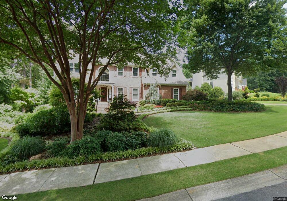
1649 Stoddard Cir NW Kennesaw, GA 30152
West Cobb NeighborhoodEstimated Value: $672,018 - $721,000
4
Beds
4
Baths
3,505
Sq Ft
$198/Sq Ft
Est. Value
About This Home
This home is located at 1649 Stoddard Cir NW, Kennesaw, GA 30152 and is currently estimated at $694,505, approximately $198 per square foot. 1649 Stoddard Cir NW is a home located in Cobb County with nearby schools including Bullard Elementary School, Mcclure Middle School, and Kennesaw Mountain High School.
Ownership History
Date
Name
Owned For
Owner Type
Purchase Details
Closed on
Apr 10, 2020
Sold by
Phillips Joel and Phillips Kathy
Bought by
Phillips Joel Delaney and Phillips Kathy Lynn
Current Estimated Value
Purchase Details
Closed on
Aug 15, 1996
Sold by
Pieczonka Dennis Sallie
Bought by
Phillips Joel Kathy
Create a Home Valuation Report for This Property
The Home Valuation Report is an in-depth analysis detailing your home's value as well as a comparison with similar homes in the area
Home Values in the Area
Average Home Value in this Area
Purchase History
| Date | Buyer | Sale Price | Title Company |
|---|---|---|---|
| Phillips Joel Delaney | -- | None Available | |
| Phillips Joel Kathy | $237,000 | -- |
Source: Public Records
Mortgage History
| Date | Status | Borrower | Loan Amount |
|---|---|---|---|
| Closed | Phillips Joel Kathy | $0 |
Source: Public Records
Tax History Compared to Growth
Tax History
| Year | Tax Paid | Tax Assessment Tax Assessment Total Assessment is a certain percentage of the fair market value that is determined by local assessors to be the total taxable value of land and additions on the property. | Land | Improvement |
|---|---|---|---|---|
| 2024 | $1,448 | $266,476 | $64,000 | $202,476 |
| 2023 | $1,148 | $235,164 | $28,000 | $207,164 |
| 2022 | $1,148 | $166,076 | $28,000 | $138,076 |
| 2021 | $1,148 | $166,076 | $28,000 | $138,076 |
| 2020 | $1,127 | $159,208 | $28,000 | $131,208 |
| 2019 | $3,903 | $157,188 | $28,000 | $129,188 |
| 2018 | $3,903 | $157,188 | $28,000 | $129,188 |
| 2017 | $3,211 | $130,932 | $23,200 | $107,732 |
| 2016 | $3,216 | $130,932 | $23,200 | $107,732 |
| 2015 | $3,284 | $130,932 | $23,200 | $107,732 |
| 2014 | $2,655 | $101,868 | $0 | $0 |
Source: Public Records
Map
Nearby Homes
- 1415 Sutters Pond Dr NW
- 1135 Weighhouse Place
- 3873 Paul Samuel Rd NW
- 3621 Sutters Pond Way NW
- 791 Lapis Trail
- 5611 Meadowstone Walk
- 5627 Meadowstone Walk
- 5623 Meadowstone Walk
- 5619 Meadowstone Walk
- 1344 Hamilton Creek Dr NW
- 1395 Crestwind Rd NW
- 1442 Crestwind Rd NW
- 1930 Stilesboro Dr NW
- 3816 Whithorn Way
- 4100 Chanticleer Dr NW
- 1558 Amberwood Creek Dr NW
- 4130 Stilesboro Rd NW
- 1653 Stoddard Cir NW
- 1647 Stoddard Cir NW
- 1655 Stoddard Cir NW
- 0 Stoddard Cir NW Unit 7148032
- 0 Stoddard Cir NW Unit 8526712
- 0 Stoddard Cir NW Unit 8133982
- 0 Stoddard Cir NW Unit 7045458
- 0 Stoddard Cir NW Unit 7101125
- 1650 Stoddard Cir NW
- 1652 Stoddard Cir NW
- 1600 Stoddard Ct NW
- 1597 Stoddard Ct NW
- 3753 Stoddard Cove NW
- 1598 Stoddard Ct NW
- 1654 Stoddard Cir NW
- 1646 Stoddard Cir NW
- 1643 Stoddard Cir NW
- 1595 Stoddard Ct NW
- 1545 Halisport Lake Dr NW
- 1657 Stoddard Cir NW