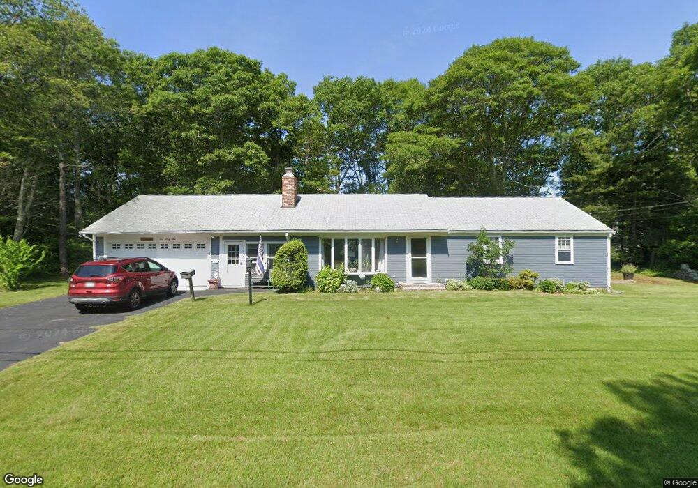
165 Buckskin Path Centerville, MA 02632
Centerville NeighborhoodEstimated Value: $567,000 - $629,000
3
Beds
2
Baths
1,248
Sq Ft
$482/Sq Ft
Est. Value
About This Home
This home is located at 165 Buckskin Path, Centerville, MA 02632 and is currently estimated at $601,184, approximately $481 per square foot. 165 Buckskin Path is a home located in Barnstable County with nearby schools including Centerville Elementary School, Barnstable United Elementary School, and Barnstable Intermediate School.
Ownership History
Date
Name
Owned For
Owner Type
Purchase Details
Closed on
Feb 1, 1993
Sold by
Scovarelli Barbara
Bought by
Johnson Gladys
Current Estimated Value
Home Financials for this Owner
Home Financials are based on the most recent Mortgage that was taken out on this home.
Original Mortgage
$55,000
Interest Rate
8.16%
Mortgage Type
Purchase Money Mortgage
Create a Home Valuation Report for This Property
The Home Valuation Report is an in-depth analysis detailing your home's value as well as a comparison with similar homes in the area
Home Values in the Area
Average Home Value in this Area
Purchase History
| Date | Buyer | Sale Price | Title Company |
|---|---|---|---|
| Johnson Gladys | $55,000 | -- |
Source: Public Records
Mortgage History
| Date | Status | Borrower | Loan Amount |
|---|---|---|---|
| Open | Johnson Gladys | $140,000 | |
| Closed | Johnson Gladys | $15,000 | |
| Closed | Johnson Gladys | $55,000 |
Source: Public Records
Tax History
| Year | Tax Paid | Tax Assessment Tax Assessment Total Assessment is a certain percentage of the fair market value that is determined by local assessors to be the total taxable value of land and additions on the property. | Land | Improvement |
|---|---|---|---|---|
| 2025 | $4,003 | $494,800 | $151,900 | $342,900 |
| 2024 | $3,844 | $492,200 | $151,900 | $340,300 |
| 2023 | $3,622 | $434,300 | $138,100 | $296,200 |
| 2022 | $3,514 | $364,500 | $102,300 | $262,200 |
| 2021 | $3,383 | $322,500 | $102,300 | $220,200 |
| 2020 | $3,404 | $310,600 | $102,300 | $208,300 |
| 2019 | $3,242 | $287,400 | $102,300 | $185,100 |
| 2018 | $2,931 | $261,200 | $107,700 | $153,500 |
| 2017 | $2,735 | $254,200 | $107,700 | $146,500 |
| 2016 | $2,780 | $255,000 | $108,500 | $146,500 |
| 2015 | $2,690 | $247,900 | $105,100 | $142,800 |
Source: Public Records
Map
Nearby Homes
- 315 Prince Hinckley Rd
- 1115 Shootflying Hill Rd
- 51 Larch Ln
- 1309 Shootflying Hill Rd
- 1309 Shootflying Hill Rd
- 900 Old Stage Rd
- 97 Yacht Club Rd
- 52 Windlass Ln
- 82 Yacht Club Rd
- 352 Nye Rd
- 169 Cedric Rd
- 436 Nye Rd
- 53 Meadow Farm Rd
- 19 Marrick Ct
- 87 Foxglove Rd
- 52 Meadow Farm Rd
- 200 Lumbert Mill Rd
- 159 Willow Run Dr
- 73 Tern Ln
- 66 Tern Ln
- 151 Buckskin Path
- 292 Skunknet Rd
- 282 Skunknet Rd
- 179 Buckskin Path
- 162 Buckskin Path
- 272 Skunknet Rd
- 302 Skunknet Rd
- 150 Buckskin Path
- 180 Buckskin Path
- 139 Buckskin Path
- 140 Buckskin Path
- 262 Skunknet Rd
- 193 Buckskin Path
- 312 Skunknet Rd
- 22 Rachel Carson Ln
- 190 Buckskin Path
- 291 Skunknet Rd
- 279 Skunknet Rd
- 30 Skunknet Rd
- 0 Skunknet Rd
Your Personal Tour Guide
Ask me questions while you tour the home.