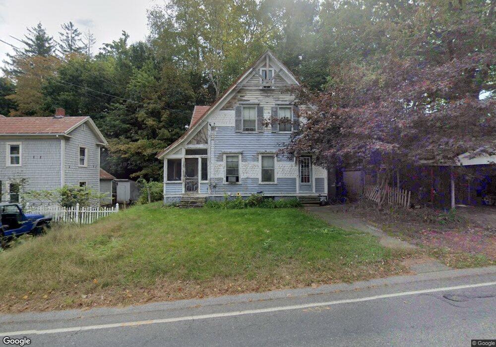
165 Maple St Warren, MA 01083
Estimated Value: $241,000 - $319,000
3
Beds
1
Bath
1,473
Sq Ft
$185/Sq Ft
Est. Value
About This Home
This home is located at 165 Maple St, Warren, MA 01083 and is currently estimated at $272,802, approximately $185 per square foot. 165 Maple St is a home with nearby schools including Quaboag Regional High School.
Ownership History
Date
Name
Owned For
Owner Type
Purchase Details
Closed on
Jun 25, 1997
Sold by
Blais Robert C and Blais Susan M
Bought by
Putis Shawn M and Putis Jennifer A
Current Estimated Value
Home Financials for this Owner
Home Financials are based on the most recent Mortgage that was taken out on this home.
Original Mortgage
$57,000
Interest Rate
7.81%
Mortgage Type
Purchase Money Mortgage
Create a Home Valuation Report for This Property
The Home Valuation Report is an in-depth analysis detailing your home's value as well as a comparison with similar homes in the area
Home Values in the Area
Average Home Value in this Area
Purchase History
| Date | Buyer | Sale Price | Title Company |
|---|---|---|---|
| Putis Shawn M | $60,000 | -- |
Source: Public Records
Mortgage History
| Date | Status | Borrower | Loan Amount |
|---|---|---|---|
| Open | Putis Shawn M | $89,000 | |
| Closed | Putis Shawn M | $16,060 | |
| Closed | Putis Shawn M | $57,000 |
Source: Public Records
Tax History
| Year | Tax Paid | Tax Assessment Tax Assessment Total Assessment is a certain percentage of the fair market value that is determined by local assessors to be the total taxable value of land and additions on the property. | Land | Improvement |
|---|---|---|---|---|
| 2025 | $2,543 | $171,700 | $46,800 | $124,900 |
| 2024 | $2,588 | $171,700 | $46,800 | $124,900 |
| 2023 | $2,542 | $160,900 | $46,800 | $114,100 |
| 2022 | $2,227 | $143,100 | $38,400 | $104,700 |
| 2021 | $9,304 | $136,400 | $36,400 | $100,000 |
| 2020 | $2,160 | $125,900 | $36,400 | $89,500 |
| 2019 | $2,174 | $119,800 | $36,400 | $83,400 |
| 2018 | $7,651 | $110,800 | $36,400 | $74,400 |
| 2017 | $2,001 | $107,800 | $37,800 | $70,000 |
| 2016 | $2,044 | $103,000 | $36,000 | $67,000 |
| 2015 | $1,853 | $98,800 | $36,000 | $62,800 |
| 2014 | $1,929 | $101,000 | $36,000 | $65,000 |
Source: Public Records
Map
Nearby Homes
- 59 High St
- 83 Comins Pond Rd
- 36 Nelson St
- Lot 4 Brimfield Rd
- Lot 8 Southbridge Rd
- LOT 7 Southbridge Rd
- Lot 5 Brimfield Rd
- Lot 3 Brimfield Rd
- 111 Quaboag St
- 17 Otis St
- 8 Otis St
- Lot 7 Reed St
- 366 Southbridge Rd
- 0 Town Farm Rd
- 352 Reed St
- 95 Town Farm Rd
- Lot 3C Crouch Rd
- Lot 2 Brimfield Rd
- Lot 1 Brimfield Rd
- 77 O'Neil Rd
- 155 Maple St
- 149 Maple St
- 150 Maple St
- 170 Maple St
- 143 Maple St
- 142 Maple St Unit 1
- 142 Maple St Unit R
- 142 Maple St
- 19 Mechanic St
- 19 Mechanic
- 18 Mechanic St
- 132 Maple St
- 24 Mechanic St Unit A
- 24 Mechanic St Unit 2
- 24 Mechanic St
- 127 Maple St
- 27 Mechanic St
- 186 Maple St
- 200 Maple St
- 126 Maple St Unit 2
Your Personal Tour Guide
Ask me questions while you tour the home.