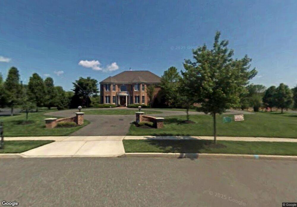
165 Pheasant Field Ln Moorestown, NJ 08057
Estimated Value: $1,322,263 - $1,766,000
--
Bed
--
Bath
4,301
Sq Ft
$366/Sq Ft
Est. Value
About This Home
This home is located at 165 Pheasant Field Ln, Moorestown, NJ 08057 and is currently estimated at $1,573,088, approximately $365 per square foot. 165 Pheasant Field Ln is a home located in Burlington County with nearby schools including George C. Baker Elementary School, Moorestown Upper Elementary School, and William Allen Middle School.
Ownership History
Date
Name
Owned For
Owner Type
Purchase Details
Closed on
Nov 15, 2002
Sold by
Duco Corp
Bought by
Downey Lois F
Current Estimated Value
Home Financials for this Owner
Home Financials are based on the most recent Mortgage that was taken out on this home.
Original Mortgage
$648,000
Interest Rate
6.34%
Mortgage Type
Credit Line Revolving
Create a Home Valuation Report for This Property
The Home Valuation Report is an in-depth analysis detailing your home's value as well as a comparison with similar homes in the area
Home Values in the Area
Average Home Value in this Area
Purchase History
| Date | Buyer | Sale Price | Title Company |
|---|---|---|---|
| Downey Lois F | $864,000 | Commonwealth Land Title Ins |
Source: Public Records
Mortgage History
| Date | Status | Borrower | Loan Amount |
|---|---|---|---|
| Closed | Downey Lois F | $648,000 |
Source: Public Records
Tax History Compared to Growth
Tax History
| Year | Tax Paid | Tax Assessment Tax Assessment Total Assessment is a certain percentage of the fair market value that is determined by local assessors to be the total taxable value of land and additions on the property. | Land | Improvement |
|---|---|---|---|---|
| 2025 | $23,524 | $829,200 | $265,700 | $563,500 |
| 2024 | $22,811 | $829,200 | $265,700 | $563,500 |
| 2023 | $22,811 | $829,200 | $265,700 | $563,500 |
| 2022 | $22,579 | $829,200 | $265,700 | $563,500 |
| 2021 | $22,281 | $829,200 | $265,700 | $563,500 |
| 2020 | $22,140 | $829,200 | $265,700 | $563,500 |
| 2019 | $21,750 | $829,200 | $265,700 | $563,500 |
| 2018 | $21,161 | $829,200 | $265,700 | $563,500 |
| 2017 | $21,344 | $829,200 | $265,700 | $563,500 |
| 2016 | $21,269 | $829,200 | $265,700 | $563,500 |
| 2015 | $21,012 | $829,200 | $265,700 | $563,500 |
| 2014 | $19,951 | $829,200 | $265,700 | $563,500 |
Source: Public Records
Map
Nearby Homes
- 343 Tom Brown Rd
- 347 Tom Brown Rd
- 863 Golf View Rd
- 142 Fox Chase Dr
- 744 Signal Light Rd
- 415 Bridgeboro Rd
- 7 Whitetail Ct
- 164 Fox Chase Dr
- 628 Windsock Way
- 2801 Riverton Rd
- 25 Oriole Way
- 110 Kathleen Ave
- 4327 Bridgeboro Rd
- 205 E Central Ave
- 693 Garwood Rd
- 128 Dorado Dr
- 543 Bethel Ave
- 139 Patricia Ave
- 228 Aqua Ln
- 308 Elm St
- 161 Pheasant Field Ln
- 169 Pheasant Field Ln
- 158 Pheasant Field Ln
- 162 Pheasant Field Ln
- 157 Pheasant Field Ln
- 173 Pheasant Field Ln
- 154 Pheasant Field Ln
- 166 Pheasant Field Ln
- 153 Pheasant Field Ln
- 177 Pheasant Field Ln
- 150 Pheasant Field Ln
- 170 Pheasant Field Ln
- 181 Pheasant Field Ln
- 149 Pheasant Field Ln
- 330 Tom Brown Rd
- 185 Pheasant Field Ln
- 145 Pheasant Field Ln
- 153 Fellswood Dr
- 157 Fellswood Dr
- 140 Pheasant Field Ln