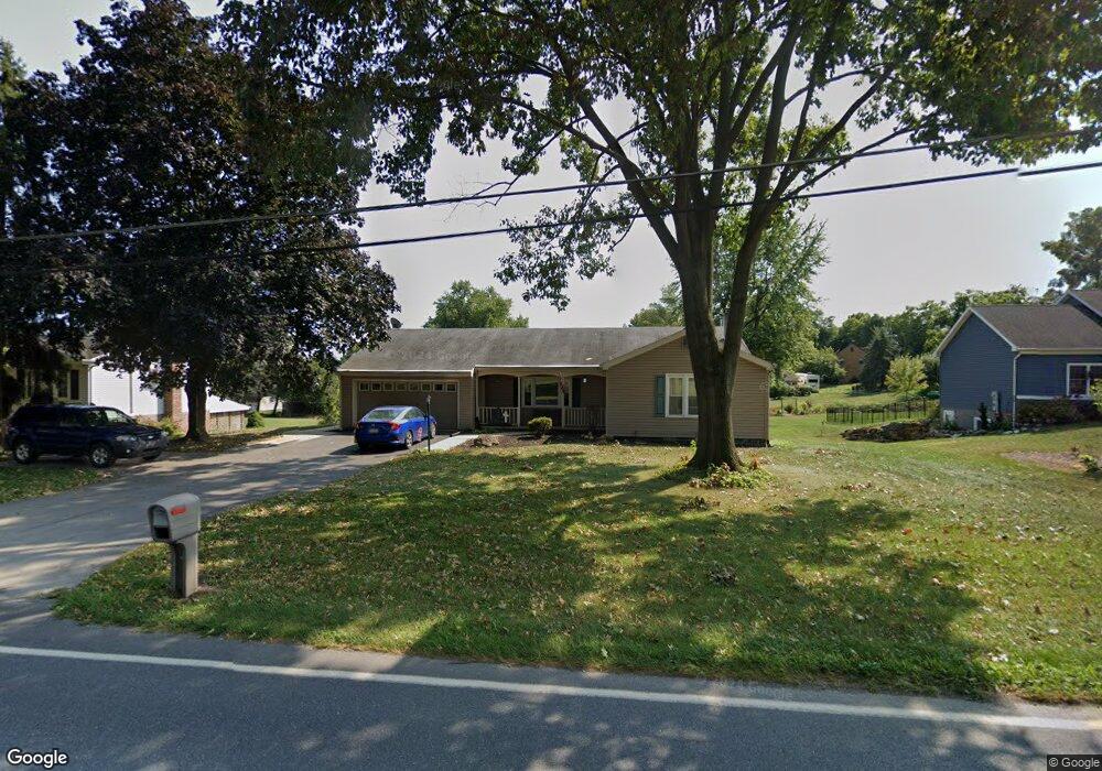
165 Rock Point Rd Marietta, PA 17547
Estimated Value: $382,585 - $437,000
4
Beds
3
Baths
1,600
Sq Ft
$250/Sq Ft
Est. Value
About This Home
This home is located at 165 Rock Point Rd, Marietta, PA 17547 and is currently estimated at $400,396, approximately $250 per square foot. 165 Rock Point Rd is a home located in Lancaster County with nearby schools including Donegal Intermediate School, Donegal High School, and Susquehanna Waldorf School.
Ownership History
Date
Name
Owned For
Owner Type
Purchase Details
Closed on
Nov 30, 2007
Sold by
Parduski Frank N and Raffety Verna M
Bought by
Parduski Craig A and Parduski Jamie L
Current Estimated Value
Home Financials for this Owner
Home Financials are based on the most recent Mortgage that was taken out on this home.
Original Mortgage
$124,000
Outstanding Balance
$79,214
Interest Rate
6.48%
Mortgage Type
Purchase Money Mortgage
Estimated Equity
$321,182
Purchase Details
Closed on
Dec 20, 2002
Sold by
Kruel John S
Bought by
Parduski Frank N and Raffety Verna M
Create a Home Valuation Report for This Property
The Home Valuation Report is an in-depth analysis detailing your home's value as well as a comparison with similar homes in the area
Home Values in the Area
Average Home Value in this Area
Purchase History
| Date | Buyer | Sale Price | Title Company |
|---|---|---|---|
| Parduski Craig A | $155,000 | None Available | |
| Parduski Frank N | $146,000 | -- |
Source: Public Records
Mortgage History
| Date | Status | Borrower | Loan Amount |
|---|---|---|---|
| Open | Parduski Craig A | $124,000 |
Source: Public Records
Tax History Compared to Growth
Tax History
| Year | Tax Paid | Tax Assessment Tax Assessment Total Assessment is a certain percentage of the fair market value that is determined by local assessors to be the total taxable value of land and additions on the property. | Land | Improvement |
|---|---|---|---|---|
| 2025 | $5,052 | $198,900 | $52,700 | $146,200 |
| 2024 | $5,052 | $198,900 | $52,700 | $146,200 |
| 2023 | $5,033 | $198,900 | $52,700 | $146,200 |
| 2022 | $4,995 | $198,900 | $52,700 | $146,200 |
| 2021 | $4,903 | $198,900 | $52,700 | $146,200 |
| 2020 | $4,903 | $198,900 | $52,700 | $146,200 |
| 2019 | $4,812 | $198,900 | $52,700 | $146,200 |
| 2018 | $3,485 | $198,900 | $52,700 | $146,200 |
| 2017 | $4,351 | $144,300 | $38,500 | $105,800 |
| 2016 | $4,351 | $144,300 | $38,500 | $105,800 |
| 2015 | $1,109 | $144,300 | $38,500 | $105,800 |
| 2014 | $3,049 | $144,300 | $38,500 | $105,800 |
Source: Public Records
Map
Nearby Homes
- 18 S Queen St
- 12 Church St
- 18 S River St
- 87 Wild Cherry Ln
- 219 Coffee Goss Rd
- 223 Coffee Goss Rd
- 361 Wild Cherry Ln
- 85 Chelmsford Dr
- 238 Chelmsford Dr
- 419 Coffee Goss Rd
- 676 W Market St
- 258 W Fairview Ave
- 518 W Market St
- 105 N Waterford Ave
- 200 E Market St
- 690 Kraybill Church Rd
- Lot 6 River Dr
- 1038 Stellar Dr
- 501 E Front St
- 219 Heathersage Dr
- 0 Rock Point Rd Unit 7 B-B 1002727417
- 0 Rock Point Rd Unit 7 B-B 1003773827
- 0 Rock Point Rd Unit 212010
- 0 Rock Point Rd Unit 217942
- 163 Rock Point Rd
- 31 Gwen Cir
- 137 E High St
- 33 Gwen Cir
- 29 Gwen Cir
- 135 E High St
- 167 Rock Point Rd
- 27 Gwen Cir
- 2756 Maytown Rd
- 2742 Maytown Rd
- 2750 Maytown Rd
- 2746 Maytown Rd
- 169 Rock Point Rd
- 25 Gwen Cir
- 32 Gwen Cir
- 129 E High St