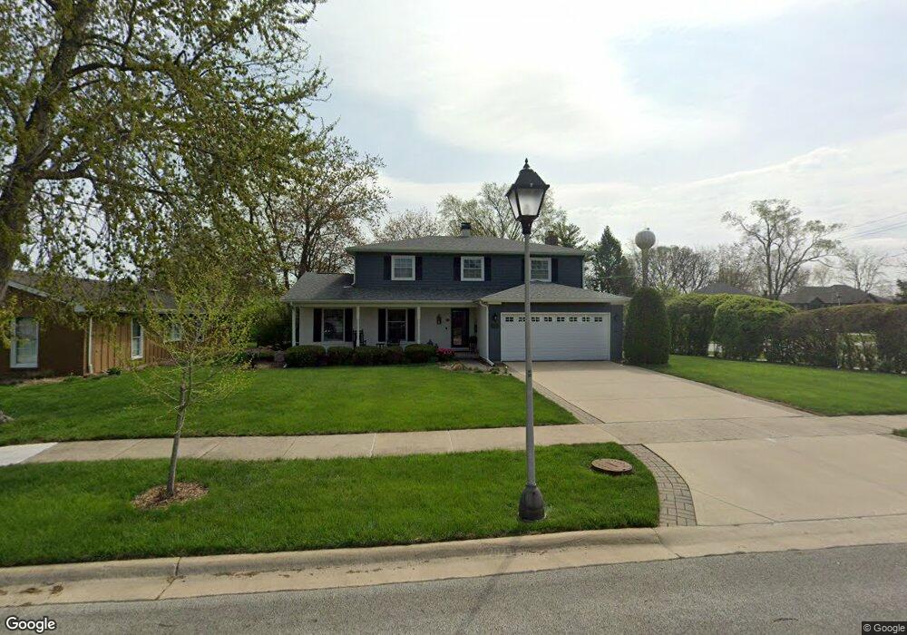
1653 Hemstock Ave Wheaton, IL 60189
West Wheaton NeighborhoodEstimated Value: $605,879 - $656,000
4
Beds
3
Baths
2,243
Sq Ft
$279/Sq Ft
Est. Value
About This Home
This home is located at 1653 Hemstock Ave, Wheaton, IL 60189 and is currently estimated at $625,220, approximately $278 per square foot. 1653 Hemstock Ave is a home located in DuPage County with nearby schools including Madison Elementary School, Edison Middle School, and Wheaton Warrenville South High School.
Ownership History
Date
Name
Owned For
Owner Type
Purchase Details
Closed on
Jan 15, 1999
Sold by
Hines William B and Hines Kathleen D
Bought by
Tober Robert D and Tober Sherry A
Current Estimated Value
Home Financials for this Owner
Home Financials are based on the most recent Mortgage that was taken out on this home.
Original Mortgage
$165,000
Outstanding Balance
$38,271
Interest Rate
6.76%
Estimated Equity
$586,949
Create a Home Valuation Report for This Property
The Home Valuation Report is an in-depth analysis detailing your home's value as well as a comparison with similar homes in the area
Home Values in the Area
Average Home Value in this Area
Purchase History
| Date | Buyer | Sale Price | Title Company |
|---|---|---|---|
| Tober Robert D | $250,000 | -- |
Source: Public Records
Mortgage History
| Date | Status | Borrower | Loan Amount |
|---|---|---|---|
| Open | Tober Robert D | $165,000 |
Source: Public Records
Tax History Compared to Growth
Tax History
| Year | Tax Paid | Tax Assessment Tax Assessment Total Assessment is a certain percentage of the fair market value that is determined by local assessors to be the total taxable value of land and additions on the property. | Land | Improvement |
|---|---|---|---|---|
| 2024 | $10,326 | $168,207 | $36,579 | $131,628 |
| 2023 | $9,923 | $154,830 | $33,670 | $121,160 |
| 2022 | $9,371 | $141,320 | $31,820 | $109,500 |
| 2021 | $9,339 | $137,960 | $31,060 | $106,900 |
| 2020 | $9,310 | $136,670 | $30,770 | $105,900 |
| 2019 | $9,097 | $133,070 | $29,960 | $103,110 |
| 2018 | $9,288 | $134,230 | $28,540 | $105,690 |
| 2017 | $9,149 | $129,280 | $27,490 | $101,790 |
| 2016 | $9,028 | $124,110 | $26,390 | $97,720 |
| 2015 | $8,959 | $118,410 | $25,180 | $93,230 |
| 2014 | $8,525 | $111,140 | $25,500 | $85,640 |
| 2013 | $8,306 | $111,480 | $25,580 | $85,900 |
Source: Public Records
Map
Nearby Homes
- 1645 Burning Trail Ct
- 1562 Burning Trail
- 1601 W Wiesbrook Rd
- 1473 Creekside Dr
- 1477 S County Farm Rd Unit 23F
- 1440 Stonebridge Cir Unit J10
- 1310 Yorkshire Woods Ct
- 212 Hamilton Ln
- 2152 Belleau Woods Dr
- 26W281 Menomini Dr
- 1S728 Shaffner Rd
- 1S710 Shaffner Rd
- 25W451 Plamondon Rd
- 1040 Creekside Dr Unit 414
- 27W020 Walz Way
- 821 Plamondon Rd
- 44 Marywood Trail
- 952 Dartmouth Dr
- 1745 Ennis Ln Unit 89A
- 51 Mitchell Cir
- 1647 Hemstock Ave
- 2009 W Wiesbrook Rd
- 1656 Hemstock Ave
- 1641 Hemstock Ave
- Lot #4 W Wiesbrook Rd
- 1651 Chelsea Ct
- 1650 Hemstock Ave
- 1650 Orth Dr Unit 1
- 1637 Hemstock Ave
- 1644 Hemstock Ave
- 1644 Orth Dr
- 1638 Orth Dr
- 1638 Hemstock Ave
- 1627 Hemstock Ave
- 2002 W Wiesbrook Rd
- 1670 Chelsea Ct
- 1671 Chelsea Ct
- 2040 W Wiesbrook Rd
- 1632 Orth Dr
- 0 Wiesbrook Rd Unit 9676180