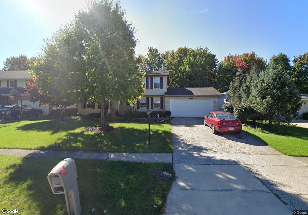
16543 S Red Rock Dr Strongsville, OH 44136
Estimated Value: $370,000 - $415,000
4
Beds
3
Baths
2,374
Sq Ft
$164/Sq Ft
Est. Value
About This Home
This home is located at 16543 S Red Rock Dr, Strongsville, OH 44136 and is currently estimated at $390,210, approximately $164 per square foot. 16543 S Red Rock Dr is a home located in Cuyahoga County with nearby schools including Strongsville High School.
Ownership History
Date
Name
Owned For
Owner Type
Purchase Details
Closed on
Sep 22, 2008
Sold by
Mack Robert H and Mack Joan A
Bought by
Mack Joan A
Current Estimated Value
Purchase Details
Closed on
May 1, 1978
Bought by
Mack Robert H
Purchase Details
Closed on
Aug 31, 1977
Bought by
Sunshine Building Co
Purchase Details
Closed on
Jan 1, 1977
Bought by
North East Land Co
Create a Home Valuation Report for This Property
The Home Valuation Report is an in-depth analysis detailing your home's value as well as a comparison with similar homes in the area
Home Values in the Area
Average Home Value in this Area
Purchase History
| Date | Buyer | Sale Price | Title Company |
|---|---|---|---|
| Mack Joan A | -- | Attorney | |
| Mack Robert H | $83,300 | -- | |
| Sunshine Building Co | $20,200 | -- | |
| North East Land Co | -- | -- |
Source: Public Records
Tax History Compared to Growth
Tax History
| Year | Tax Paid | Tax Assessment Tax Assessment Total Assessment is a certain percentage of the fair market value that is determined by local assessors to be the total taxable value of land and additions on the property. | Land | Improvement |
|---|---|---|---|---|
| 2024 | $4,979 | $115,850 | $22,015 | $93,835 |
| 2023 | $4,977 | $88,660 | $22,300 | $66,360 |
| 2022 | $4,967 | $88,655 | $22,295 | $66,360 |
| 2021 | $4,928 | $88,660 | $22,300 | $66,360 |
| 2020 | $4,455 | $72,660 | $18,270 | $54,390 |
| 2019 | $4,324 | $207,600 | $52,200 | $155,400 |
| 2018 | $3,906 | $72,660 | $18,270 | $54,390 |
| 2017 | $3,959 | $68,430 | $14,460 | $53,970 |
| 2016 | $3,927 | $68,430 | $14,460 | $53,970 |
| 2015 | $3,982 | $68,430 | $14,460 | $53,970 |
| 2014 | $3,982 | $68,430 | $14,460 | $53,970 |
Source: Public Records
Map
Nearby Homes
- 16486 S Red Rock Dr
- 17159 Turkey Meadow Ln
- 17130 Golden Star Dr
- 17682 Drake Rd
- 18229 Howe Rd
- 16711 Beech Cir
- 17024 Bear Creek Ln
- 16650 Lanier Ave
- 18411 Yorktown Oval
- 17934 Cambridge Oval
- 18294 Drake Rd
- 16450 Howe Rd
- 3550 Boston Rd
- 15604-REAR Boston Rd
- 19694 Benbow Rd
- 14985 Camden Cir
- 19740 Benbow Rd
- 17069 Partridge Dr
- 18987 Laurell Cir
- 18848 Pearl Rd
- 16547 S Red Rock Dr
- 16539 S Red Rock Dr
- 16535 S Red Rock Dr
- 16551 S Red Rock Dr
- 16540 Pepper Grass Cir
- 16544 Pepper Grass Cir
- 16536 Pepper Grass Cir
- 16531 S Red Rock Dr
- 16544 S Red Rock Dr
- 16555 S Red Rock Dr
- 16548 S Red Rock Dr
- 16540 S Red Rock Dr
- 17159 Penny Pines Cir
- 16552 S Red Rock Dr
- 17163 Penny Pines Cir
- 16548 Pepper Grass Cir
- 16536 S Red Rock Dr
- 16527 S Red Rock Dr
- 16532 Pepper Grass Cir
- 16533 N Red Rock Dr