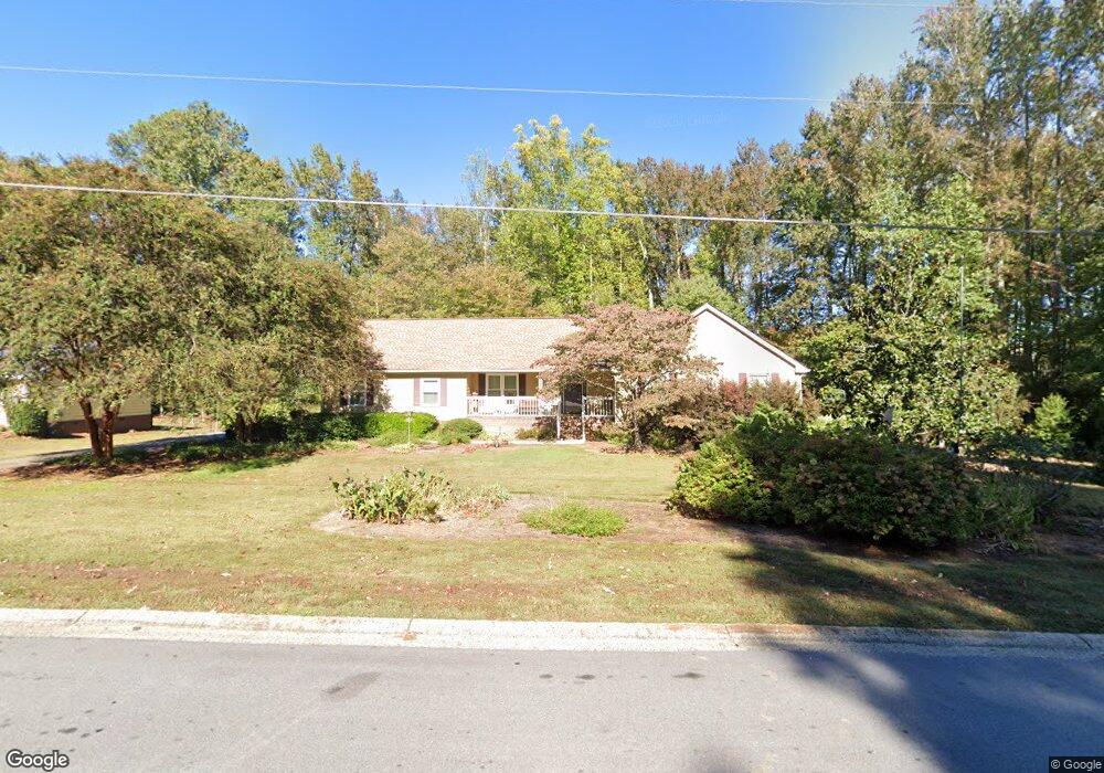
1657 Norton Estates Cir Snellville, GA 30078
Estimated Value: $355,073 - $385,000
4
Beds
2
Baths
2,402
Sq Ft
$155/Sq Ft
Est. Value
About This Home
This home is located at 1657 Norton Estates Cir, Snellville, GA 30078 and is currently estimated at $373,018, approximately $155 per square foot. 1657 Norton Estates Cir is a home located in Gwinnett County with nearby schools including Brookwood Elementary School, Alton C. Crews Middle School, and Brookwood High School.
Ownership History
Date
Name
Owned For
Owner Type
Purchase Details
Closed on
Jun 15, 2009
Sold by
Downing Ray B and Downing Linda
Bought by
Kelley Charles P and Kelley Janice L
Current Estimated Value
Create a Home Valuation Report for This Property
The Home Valuation Report is an in-depth analysis detailing your home's value as well as a comparison with similar homes in the area
Home Values in the Area
Average Home Value in this Area
Purchase History
| Date | Buyer | Sale Price | Title Company |
|---|---|---|---|
| Kelley Charles P | $147,000 | -- |
Source: Public Records
Tax History Compared to Growth
Tax History
| Year | Tax Paid | Tax Assessment Tax Assessment Total Assessment is a certain percentage of the fair market value that is determined by local assessors to be the total taxable value of land and additions on the property. | Land | Improvement |
|---|---|---|---|---|
| 2025 | -- | $161,720 | $22,360 | $139,360 |
| 2024 | -- | $148,520 | $22,360 | $126,160 |
| 2023 | $1,091 | $156,760 | $25,040 | $131,720 |
| 2022 | $1,190 | $122,600 | $23,440 | $99,160 |
| 2021 | $1,190 | $87,280 | $15,040 | $72,240 |
| 2020 | $1,100 | $87,280 | $15,040 | $72,240 |
| 2019 | $1,100 | $77,240 | $15,040 | $62,200 |
| 2018 | $1,088 | $73,960 | $11,840 | $62,120 |
| 2016 | $2,393 | $62,120 | $11,840 | $50,280 |
| 2015 | $2,224 | $56,880 | $9,040 | $47,840 |
| 2014 | -- | $39,640 | $8,120 | $31,520 |
Source: Public Records
Map
Nearby Homes
- 1686 Norton Estates Dr
- 3063 Bruckner Blvd
- 1750 Manor Brook Way
- 1953 Watson Park Dr
- 1845 Lisa Springs Dr
- 1220 Edgebrook Ln
- 2691 Holly Springs Dr
- 3173 Falconhurst Dr SW
- Kenwood Plan at Watson Park
- Stockbridge Plan at Watson Park
- Aiken Plan at Watson Park
- Lawrence Plan at Watson Park
- Easton Plan at Watson Park
- 1809 Mornington Ln
- 1526 Lechemin Dr
- 3207 Aspen Cir SW
- 3075 Oak Meadow Dr
- 1328 Apple Orchard Ln
- 1937 Crescent Dr
- 1661 Norton Estates Cir
- 1649 Norton Estates Cir
- 1700 Karis Oak Ln
- 1690 Karis Oak Ln
- 1652 Norton Estates Cir
- 1656 Norton Estates Cir
- 1665 Norton Estates Cir Unit 1
- 1660 Norton Estates Cir Unit 1
- 1701 Karis Oak Ln
- 1680 Karis Oak Ln
- 1645 Norton Estates Cir
- 3028 Brook Oak Trace
- 1670 Norton Estates Cir Unit 1
- 3018 Brook Oak Trace
- 1644 Norton Estates Cir Unit 1
- 3038 Brook Oak Trace
- 1669 Norton Estates Cir
- 1691 Karis Oak Ln
- 1670 Karis Oak Ln
- 3008 Brook Oak Trace