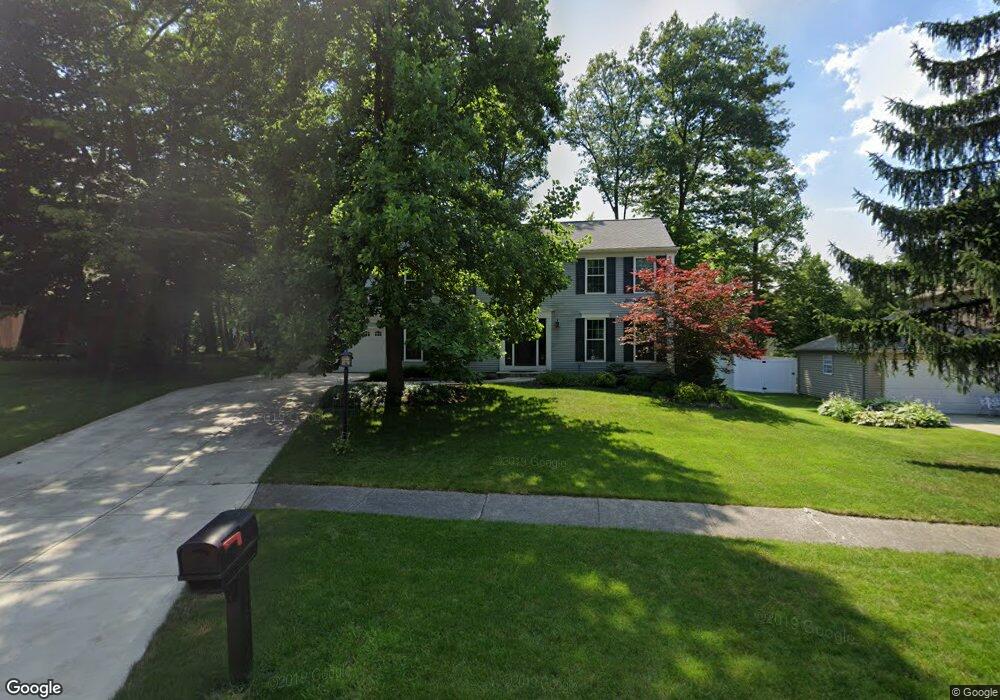
16584 N White Oaks Dr Strongsville, OH 44136
Estimated Value: $370,155 - $387,000
4
Beds
3
Baths
2,298
Sq Ft
$164/Sq Ft
Est. Value
About This Home
This home is located at 16584 N White Oaks Dr, Strongsville, OH 44136 and is currently estimated at $376,789, approximately $163 per square foot. 16584 N White Oaks Dr is a home located in Cuyahoga County with nearby schools including Strongsville High School and Saint Ambrose Catholic School.
Ownership History
Date
Name
Owned For
Owner Type
Purchase Details
Closed on
Aug 9, 2007
Sold by
Mertz Lori A
Bought by
Brown Michael E and Brown Lorie A
Current Estimated Value
Home Financials for this Owner
Home Financials are based on the most recent Mortgage that was taken out on this home.
Original Mortgage
$20,000
Outstanding Balance
$12,734
Interest Rate
6.77%
Mortgage Type
Credit Line Revolving
Estimated Equity
$364,055
Purchase Details
Closed on
Sep 27, 2000
Sold by
Mertz Donald A
Bought by
Mertz Lori A
Purchase Details
Closed on
Mar 1, 1991
Sold by
Leiner Gerd
Bought by
Mertz Donald A
Purchase Details
Closed on
Jul 25, 1989
Sold by
Deroy Gerald L and Deroy Janine M
Bought by
Leiner Gerd
Purchase Details
Closed on
Apr 3, 1985
Sold by
Deroy Gerald L
Bought by
Deroy Gerald L and Deroy Janine M
Purchase Details
Closed on
Apr 17, 1978
Bought by
Deroy Gerald L
Purchase Details
Closed on
Nov 22, 1977
Bought by
Production Homes Inc
Purchase Details
Closed on
Jan 1, 1977
Bought by
North East Land Co
Create a Home Valuation Report for This Property
The Home Valuation Report is an in-depth analysis detailing your home's value as well as a comparison with similar homes in the area
Home Values in the Area
Average Home Value in this Area
Purchase History
| Date | Buyer | Sale Price | Title Company |
|---|---|---|---|
| Brown Michael E | $214,000 | Real Living Title Agency Ltd | |
| Mertz Lori A | -- | -- | |
| Mertz Donald A | $159,000 | -- | |
| Leiner Gerd | $160,000 | -- | |
| Deroy Gerald L | -- | -- | |
| Deroy Gerald L | $87,900 | -- | |
| Production Homes Inc | $23,000 | -- | |
| North East Land Co | -- | -- |
Source: Public Records
Mortgage History
| Date | Status | Borrower | Loan Amount |
|---|---|---|---|
| Open | Brown Michael E | $20,000 | |
| Open | Brown Michael E | $171,200 |
Source: Public Records
Tax History Compared to Growth
Tax History
| Year | Tax Paid | Tax Assessment Tax Assessment Total Assessment is a certain percentage of the fair market value that is determined by local assessors to be the total taxable value of land and additions on the property. | Land | Improvement |
|---|---|---|---|---|
| 2024 | $5,477 | $116,655 | $23,170 | $93,485 |
| 2023 | $5,825 | $93,030 | $23,520 | $69,510 |
| 2022 | $5,783 | $93,030 | $23,520 | $69,510 |
| 2021 | $5,737 | $93,030 | $23,520 | $69,510 |
| 2020 | $5,317 | $76,270 | $19,290 | $56,980 |
| 2019 | $5,161 | $217,900 | $55,100 | $162,800 |
| 2018 | $4,681 | $76,270 | $19,290 | $56,980 |
| 2017 | $4,765 | $71,830 | $15,300 | $56,530 |
| 2016 | $4,726 | $71,830 | $15,300 | $56,530 |
| 2015 | $4,793 | $71,830 | $15,300 | $56,530 |
| 2014 | $4,793 | $71,830 | $15,300 | $56,530 |
Source: Public Records
Map
Nearby Homes
- 16711 Beech Cir
- 16486 S Red Rock Dr
- 17130 Golden Star Dr
- 17159 Turkey Meadow Ln
- 17682 Drake Rd
- 18229 Howe Rd
- 18411 Yorktown Oval
- 17024 Bear Creek Ln
- 17934 Cambridge Oval
- 3550 Boston Rd
- 18294 Drake Rd
- 16650 Lanier Ave
- 15604-REAR Boston Rd
- 19694 Benbow Rd
- 97 Weathervane Ln
- 18848 Pearl Rd
- 19740 Benbow Rd
- 14985 Camden Cir
- 15188 Trails Landing
- 18987 Laurell Cir
- 16580 N White Oaks Dr
- 16588 S White Oaks Dr
- 18509 Nantucket Row
- 18477 Nantucket Row
- 16591 S White Oaks Dr
- 18541 Nantucket Row
- 16572 N White Oaks Dr
- 16566 S White Oaks Dr
- 18445 Nantucket Row
- 16589 S White Oaks Dr
- 16561 N White Oaks Dr
- 18573 Nantucket Row
- 16568 N White Oaks Dr
- 17006 Falmouth Dr
- 16562 S White Oaks Dr
- 17040 Falmouth Dr
- 16972 Falmouth Dr
- 18421 Nantucket Row
- 17074 Falmouth Dr
- 16938 Falmouth Dr