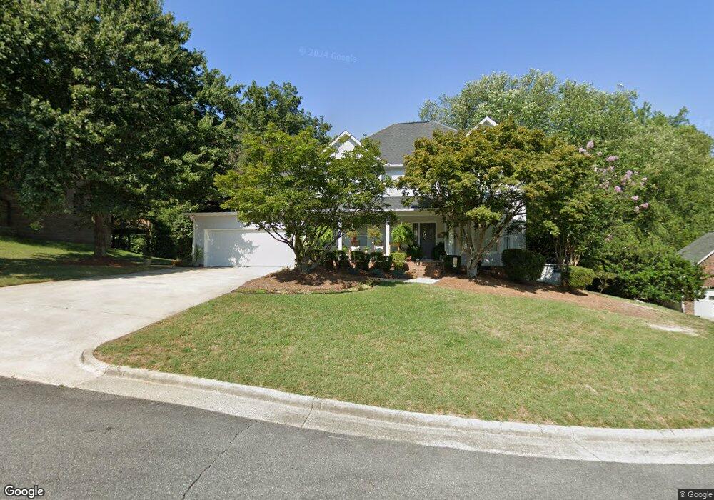
166 Cottontail Ln SE Concord, NC 28025
Estimated Value: $486,004 - $548,000
3
Beds
3
Baths
2,769
Sq Ft
$183/Sq Ft
Est. Value
About This Home
This home is located at 166 Cottontail Ln SE, Concord, NC 28025 and is currently estimated at $506,001, approximately $182 per square foot. 166 Cottontail Ln SE is a home located in Cabarrus County with nearby schools including W.M. Irvin Elementary School, Mount Pleasant Middle School, and Mount Pleasant High School.
Ownership History
Date
Name
Owned For
Owner Type
Purchase Details
Closed on
Jul 10, 2007
Sold by
Perkins Deborah D
Bought by
Waller Steven Paul and Waller Stephanie Gardner
Current Estimated Value
Home Financials for this Owner
Home Financials are based on the most recent Mortgage that was taken out on this home.
Original Mortgage
$265,000
Outstanding Balance
$164,332
Interest Rate
6.35%
Mortgage Type
Purchase Money Mortgage
Estimated Equity
$341,669
Purchase Details
Closed on
May 1, 1991
Bought by
Perkins Deborah D
Purchase Details
Closed on
Sep 1, 1989
Create a Home Valuation Report for This Property
The Home Valuation Report is an in-depth analysis detailing your home's value as well as a comparison with similar homes in the area
Home Values in the Area
Average Home Value in this Area
Purchase History
| Date | Buyer | Sale Price | Title Company |
|---|---|---|---|
| Waller Steven Paul | $279,000 | None Available | |
| Perkins Deborah D | $192,000 | -- | |
| -- | $190,000 | -- |
Source: Public Records
Mortgage History
| Date | Status | Borrower | Loan Amount |
|---|---|---|---|
| Open | Waller Steven Paul | $265,000 |
Source: Public Records
Tax History
| Year | Tax Paid | Tax Assessment Tax Assessment Total Assessment is a certain percentage of the fair market value that is determined by local assessors to be the total taxable value of land and additions on the property. | Land | Improvement |
|---|---|---|---|---|
| 2025 | $4,407 | $442,480 | $94,000 | $348,480 |
| 2024 | $4,407 | $442,480 | $94,000 | $348,480 |
| 2023 | $3,487 | $285,780 | $60,000 | $225,780 |
| 2022 | $3,372 | $276,410 | $60,000 | $216,410 |
| 2021 | $3,372 | $276,410 | $60,000 | $216,410 |
| 2020 | $3,372 | $276,410 | $60,000 | $216,410 |
| 2019 | $2,956 | $242,270 | $42,000 | $200,270 |
| 2018 | $2,907 | $242,270 | $42,000 | $200,270 |
| 2017 | $2,859 | $242,270 | $42,000 | $200,270 |
| 2016 | $1,696 | $239,820 | $42,000 | $197,820 |
| 2015 | $2,830 | $239,820 | $42,000 | $197,820 |
| 2014 | $2,830 | $239,820 | $42,000 | $197,820 |
Source: Public Records
Map
Nearby Homes
- 153 Cottontail Ln SE Unit 46
- 1086 Arrowhead Dr SE
- 425 Krimminger Ave SE
- 2522 Willow Pond Ln SE
- 29 Plott Dr SW
- 267 Ikerd Dr SE
- 1193 Tangle Ridge Dr SE
- 2406 Everton Cir SE
- 271 Ikerd Dr SE
- 1160 Tangle Ridge Dr SE
- 921 Pineridge St SE
- 1128 Tangle Ridge Dr SE
- 94 Cumberland Ct SW
- 2365 Baxter Place SE
- 2369 Baxter Place SE
- 2568 Chelsea Dr
- 847 Kathryn Dr SE
- 745 Carolyn Dr SE
- 783 Union St S
- 782 Union St S
- 164 Cottontail Ln SE
- 168 Cottontail Ln SE
- 162 Cottontail Ln SE
- 169 Cottontail Ln SE
- 163 Cottontail Ln SE
- 167 Cottontail Ln SE
- 160 Cottontail Ln SE
- 201 Spaniel Dr SE
- 250 Old Airport Rd
- 224 Canvasback Ct SE
- 226 Canvasback Ct SE
- 203 Spaniel Dr SE
- 222 Canvasback Ct SE
- 228 Canvasback Ct SE
- 158 Cottontail Ln SE
- 230 Canvasback Ct SE
- 157 Cottontail Ln SE
- 151 Old Airport Rd
- 161 Old Airport Rd
- 204 Spaniel Dr SE
Your Personal Tour Guide
Ask me questions while you tour the home.