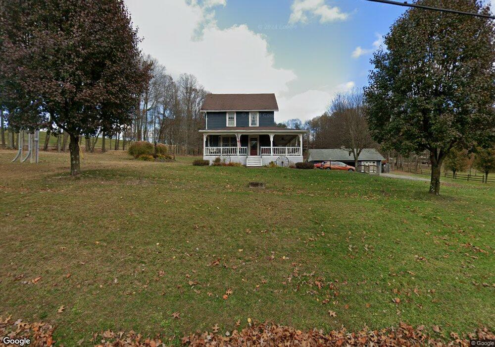
166 Martin Rd Indiana, PA 15701
Estimated Value: $100,593 - $120,000
2
Beds
1
Bath
1,027
Sq Ft
$109/Sq Ft
Est. Value
About This Home
This home is located at 166 Martin Rd, Indiana, PA 15701 and is currently estimated at $112,398, approximately $109 per square foot. 166 Martin Rd is a home located in Indiana County with nearby schools including Indiana Area Junior High School, Indiana Area Senior High School, and Keys Montessori School.
Ownership History
Date
Name
Owned For
Owner Type
Purchase Details
Closed on
Jun 26, 2020
Sold by
Zorabedian John and Zorabedian Stephanie Elizabeth
Bought by
Fryer Erik and Alexander Constance G
Current Estimated Value
Home Financials for this Owner
Home Financials are based on the most recent Mortgage that was taken out on this home.
Original Mortgage
$78,452
Outstanding Balance
$69,566
Interest Rate
3.1%
Mortgage Type
FHA
Estimated Equity
$42,832
Purchase Details
Closed on
Aug 18, 2014
Sold by
Roche John David and Roche Julie
Bought by
Zorabedian John and Zorabedian Stephanie Elizabeth Holliday
Home Financials for this Owner
Home Financials are based on the most recent Mortgage that was taken out on this home.
Original Mortgage
$77,551
Interest Rate
4.09%
Mortgage Type
New Conventional
Purchase Details
Closed on
Mar 24, 2010
Sold by
Schroth Kenneth and Schroth Susan
Bought by
Schroth Edward
Create a Home Valuation Report for This Property
The Home Valuation Report is an in-depth analysis detailing your home's value as well as a comparison with similar homes in the area
Home Values in the Area
Average Home Value in this Area
Purchase History
| Date | Buyer | Sale Price | Title Company |
|---|---|---|---|
| Fryer Erik | $79,900 | Everest Settlement | |
| Zorabedian John | $76,000 | None Available | |
| Schroth Edward | -- | None Available |
Source: Public Records
Mortgage History
| Date | Status | Borrower | Loan Amount |
|---|---|---|---|
| Open | Fryer Erik | $78,452 | |
| Previous Owner | Zorabedian John | $77,551 |
Source: Public Records
Tax History Compared to Growth
Tax History
| Year | Tax Paid | Tax Assessment Tax Assessment Total Assessment is a certain percentage of the fair market value that is determined by local assessors to be the total taxable value of land and additions on the property. | Land | Improvement |
|---|---|---|---|---|
| 2025 | $2,385 | $79,100 | $14,800 | $64,300 |
| 2024 | $2,207 | $79,100 | $14,800 | $64,300 |
| 2023 | $2,090 | $79,100 | $14,800 | $64,300 |
| 2022 | $2,079 | $79,100 | $14,800 | $64,300 |
| 2021 | $2,079 | $79,100 | $14,800 | $64,300 |
| 2020 | $2,043 | $79,100 | $14,800 | $64,300 |
| 2018 | $2,011 | $79,100 | $14,800 | $64,300 |
| 2017 | $1,946 | $79,100 | $14,800 | $64,300 |
| 2016 | -- | $79,100 | $14,800 | $64,300 |
| 2015 | -- | $9,120 | $2,600 | $6,520 |
| 2014 | -- | $9,120 | $2,600 | $6,520 |
Source: Public Records
Map
Nearby Homes
- 0 Sunset Dr Unit 1697645
- 0 Sunset Dr Unit 1699295
- 0 Sunset Dr Unit 1730874
- 30 Croyhill Dr
- 729 Fairview Ave
- 420 Edgewood Ave
- 860 N 5th Ave
- 967 Josephine Ave
- 336 N Taylor Ave
- 530 Stannard Ave
- Lot #2 Hawk's Nest Cir
- Lot #12 Hunter's Creek
- Lot #1 Indian Hills Dr
- 336 N 5th St
- 313 N 11th St
- 557 Oak St
- 926 Oak St
- 270 Charles St
- 211 N 5th St
- 535 Burns Ave
- 166 Martin Rd
- 201 Martin Rd
- 217 Martin Rd
- 277 Martin Rd
- 870 White Farm Rd
- 880 White Farm Rd
- 85 Pine Crest Dr
- 99 Pine Crest Dr
- 892 White Farm Rd
- 75 Pine Crest Dr
- 0 Martin Rd
- 896 White Farm Rd
- 881 White Farm Rd
- 881 White Farm Rd
- 881 White Farm Rd
- 858 White Farm Rd
- 100 Pine Crest Dr
- 45 Pine Crest Dr
- 862 White Farm Rd
- 891 White Farm Rd