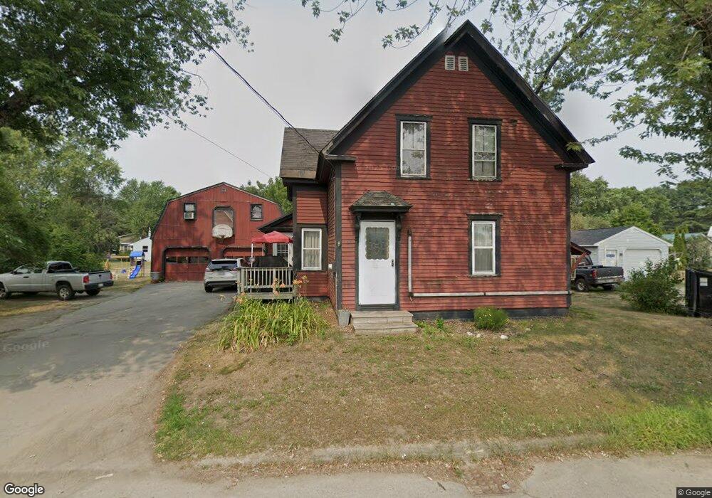
166 North Ave Skowhegan, ME 04976
Estimated Value: $170,218 - $234,000
4
Beds
1
Bath
1,455
Sq Ft
$147/Sq Ft
Est. Value
About This Home
This home is located at 166 North Ave, Skowhegan, ME 04976 and is currently estimated at $213,305, approximately $146 per square foot. 166 North Ave is a home located in Somerset County with nearby schools including Creative Children's Academy, Overman Academy, and Faith Baptist Christian School.
Ownership History
Date
Name
Owned For
Owner Type
Purchase Details
Closed on
Nov 29, 2011
Sold by
Johnson Cynthia A and Johnson Cyprien J
Bought by
Cole Thomas G and Cole Linda M
Current Estimated Value
Home Financials for this Owner
Home Financials are based on the most recent Mortgage that was taken out on this home.
Original Mortgage
$88,469
Outstanding Balance
$60,837
Interest Rate
4.12%
Mortgage Type
Purchase Money Mortgage
Estimated Equity
$152,468
Create a Home Valuation Report for This Property
The Home Valuation Report is an in-depth analysis detailing your home's value as well as a comparison with similar homes in the area
Home Values in the Area
Average Home Value in this Area
Purchase History
| Date | Buyer | Sale Price | Title Company |
|---|---|---|---|
| Cole Thomas G | -- | -- |
Source: Public Records
Mortgage History
| Date | Status | Borrower | Loan Amount |
|---|---|---|---|
| Open | Cole Thomas G | $88,469 |
Source: Public Records
Tax History Compared to Growth
Tax History
| Year | Tax Paid | Tax Assessment Tax Assessment Total Assessment is a certain percentage of the fair market value that is determined by local assessors to be the total taxable value of land and additions on the property. | Land | Improvement |
|---|---|---|---|---|
| 2024 | $2,064 | $114,200 | $24,100 | $90,100 |
| 2023 | $2,024 | $114,200 | $24,100 | $90,100 |
| 2022 | $1,475 | $84,400 | $16,700 | $67,700 |
| 2021 | $1,442 | $78,600 | $16,700 | $61,900 |
| 2020 | $1,327 | $73,700 | $16,700 | $57,000 |
| 2019 | $1,271 | $73,700 | $16,700 | $57,000 |
| 2018 | $1,341 | $73,700 | $16,700 | $57,000 |
| 2017 | $1,474 | $73,700 | $16,700 | $57,000 |
| 2016 | $1,386 | $72,800 | $17,700 | $55,100 |
| 2015 | $1,332 | $72,800 | $17,700 | $55,100 |
| 2014 | $1,249 | $72,800 | $17,700 | $55,100 |
| 2013 | $1,194 | $72,800 | $17,700 | $55,100 |
Source: Public Records
Map
Nearby Homes
- M33 L94-1 (Lot 17) Reed St
- M33 L94-1 (Lot 17 & 18) Reed St
- 36 Saint Mark St
- 19 Prospect St
- 27 Adams St
- 86 North Ave
- 18 Maple St
- 50 Hanover St
- 55 Beech St
- 257 North Ave
- 13 Maple St
- 28 Dr Mann Rd
- 25 Winter St
- 131 Madison Ave
- 17 Heselton St
- 106 Russell Rd
- M1 L27 North Ave
- 18 Leavitt St
- 346 Water St
- 23 Bennett Ave