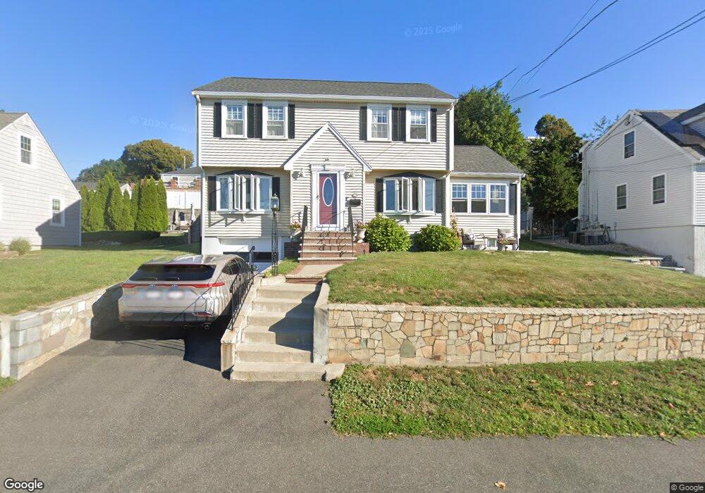
166 River St North Weymouth, MA 02191
North Weymouth NeighborhoodEstimated Value: $780,000 - $863,000
4
Beds
2
Baths
1,856
Sq Ft
$441/Sq Ft
Est. Value
About This Home
This home is located at 166 River St, North Weymouth, MA 02191 and is currently estimated at $818,809, approximately $441 per square foot. 166 River St is a home located in Norfolk County with nearby schools including Wessagusset Elementary School, Abigail Adams Middle School, and Weymouth Middle School Chapman.
Ownership History
Date
Name
Owned For
Owner Type
Purchase Details
Closed on
Oct 5, 2022
Sold by
Hoyt Peter and Hoyt Janice M
Bought by
Hoyt Ft and Hoyt
Current Estimated Value
Purchase Details
Closed on
Aug 20, 2007
Sold by
Lamb Robert and Lamb
Bought by
Lamb Brian
Create a Home Valuation Report for This Property
The Home Valuation Report is an in-depth analysis detailing your home's value as well as a comparison with similar homes in the area
Home Values in the Area
Average Home Value in this Area
Purchase History
| Date | Buyer | Sale Price | Title Company |
|---|---|---|---|
| Hoyt Ft | -- | None Available | |
| Hoyt Ft | -- | None Available | |
| Lamb Brian | -- | -- |
Source: Public Records
Mortgage History
| Date | Status | Borrower | Loan Amount |
|---|---|---|---|
| Previous Owner | Lamb Brian | $389,000 | |
| Previous Owner | Lamb Brian | $60,000 |
Source: Public Records
Tax History Compared to Growth
Tax History
| Year | Tax Paid | Tax Assessment Tax Assessment Total Assessment is a certain percentage of the fair market value that is determined by local assessors to be the total taxable value of land and additions on the property. | Land | Improvement |
|---|---|---|---|---|
| 2025 | $6,961 | $689,200 | $263,100 | $426,100 |
| 2024 | $6,801 | $662,200 | $250,600 | $411,600 |
| 2023 | $6,288 | $601,700 | $232,100 | $369,600 |
| 2022 | $6,169 | $538,300 | $214,900 | $323,400 |
| 2021 | $5,944 | $506,300 | $214,900 | $291,400 |
| 2020 | $5,713 | $479,300 | $214,900 | $264,400 |
| 2019 | $5,610 | $462,900 | $206,600 | $256,300 |
| 2018 | $5,431 | $434,500 | $196,800 | $237,700 |
| 2017 | $5,338 | $416,700 | $187,400 | $229,300 |
| 2016 | $5,164 | $403,400 | $180,200 | $223,200 |
| 2015 | $4,978 | $385,900 | $180,200 | $205,700 |
| 2014 | $4,934 | $371,000 | $180,200 | $190,800 |
Source: Public Records
Map
Nearby Homes
- 16 Caldwell St
- 12 Wolcott St
- 51 Broad Reach Unit T23A
- 61 Broad Reach Unit T62B
- 73 Broad Reach Unit T123C
- 73 Broad Reach Unit M33C
- 73 Broad Reach Unit T41C
- 130 Broad Reach Unit 506
- 130 Broad Reach Unit 305
- 130 Broad Reach Unit 206
- 130 Broad Reach Unit 504
- 69 Great Hill Dr
- 10 Shipyard Dr Unit 313
- 141 Hms Stayner Dr Unit 306
- 125 Halsted Dr Unit 125
- 95 Fuller Rd
- 16 Beal's Cove Rd Unit E
- 41 Pecksuot Rd
- 6 Beal's Cove Rd Unit G
- 17 Beals Cove Rd Unit A
- 160 River St
- 170 River St
- 140 Prospect Hill Dr
- 144 Prospect Hill Dr
- 144 Prospect Hill Dr Unit 1
- 136 Prospect Hill Dr
- 156 River St
- 150 Prospect Hill Dr
- 180 River St
- 154 River St
- 158 Prospect Hill Dr
- 141 Prospect Hill Dr
- 137 Prospect Hill Dr
- 126 Prospect Hill Dr
- 184 River St
- 151 Prospect Hill Dr
- 11 Hilltop Rd
- 122 Prospect Hill Dr
- 39 Hilltop Rd
- 11 Prospect Hill Dr