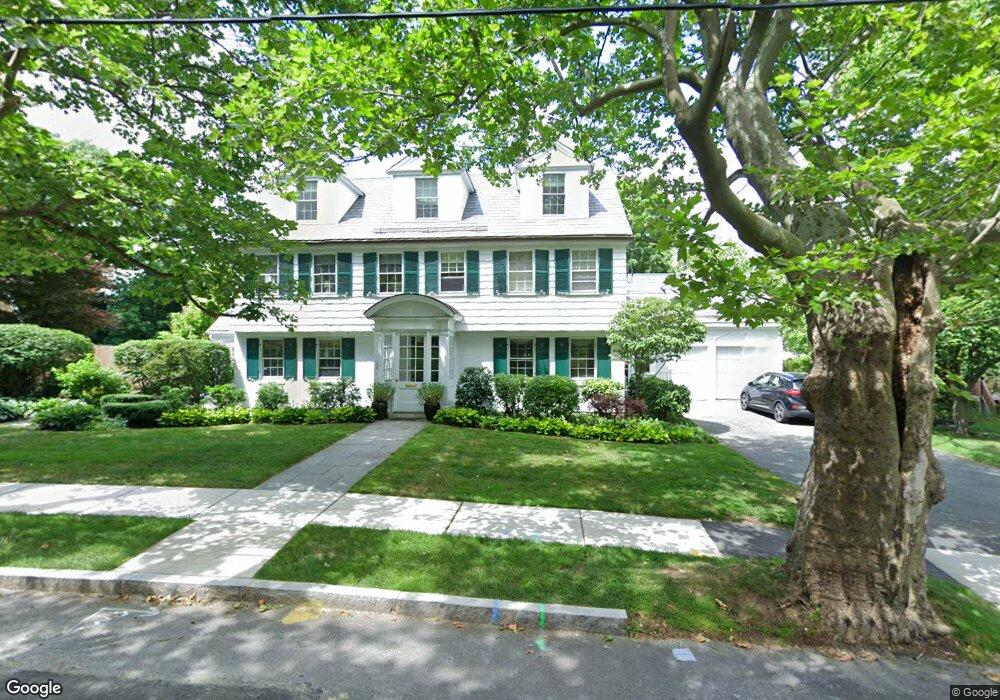
166 Walnut Hill Rd Chestnut Hill, MA 02467
South Brookline NeighborhoodEstimated Value: $2,070,000 - $3,036,000
4
Beds
4
Baths
3,365
Sq Ft
$792/Sq Ft
Est. Value
About This Home
This home is located at 166 Walnut Hill Rd, Chestnut Hill, MA 02467 and is currently estimated at $2,665,845, approximately $792 per square foot. 166 Walnut Hill Rd is a home located in Norfolk County with nearby schools including Baker School, Mount Alvernia Academy, and Dexter School.
Ownership History
Date
Name
Owned For
Owner Type
Purchase Details
Closed on
Jun 5, 2008
Sold by
Nina Rt
Bought by
Schmults Robert C and Schmults Chrysalyne
Current Estimated Value
Home Financials for this Owner
Home Financials are based on the most recent Mortgage that was taken out on this home.
Original Mortgage
$410,000
Outstanding Balance
$263,901
Interest Rate
6.11%
Mortgage Type
Purchase Money Mortgage
Estimated Equity
$2,401,944
Purchase Details
Closed on
Aug 17, 2004
Sold by
Ramin Elsa K
Bought by
Ramin Elsa K and Ramin Gerald R
Create a Home Valuation Report for This Property
The Home Valuation Report is an in-depth analysis detailing your home's value as well as a comparison with similar homes in the area
Home Values in the Area
Average Home Value in this Area
Purchase History
| Date | Buyer | Sale Price | Title Company |
|---|---|---|---|
| Schmults Robert C | $1,200,000 | -- | |
| Ramin Elsa K | -- | -- |
Source: Public Records
Mortgage History
| Date | Status | Borrower | Loan Amount |
|---|---|---|---|
| Open | Schmults Robert C | $410,000 |
Source: Public Records
Tax History Compared to Growth
Tax History
| Year | Tax Paid | Tax Assessment Tax Assessment Total Assessment is a certain percentage of the fair market value that is determined by local assessors to be the total taxable value of land and additions on the property. | Land | Improvement |
|---|---|---|---|---|
| 2025 | $26,186 | $2,653,100 | $779,200 | $1,873,900 |
| 2024 | $25,013 | $2,560,200 | $749,200 | $1,811,000 |
| 2023 | $23,362 | $2,343,200 | $607,500 | $1,735,700 |
| 2022 | $22,741 | $2,231,700 | $578,600 | $1,653,100 |
| 2021 | $21,029 | $2,145,800 | $556,300 | $1,589,500 |
| 2020 | $15,944 | $1,687,200 | $505,800 | $1,181,400 |
| 2019 | $14,676 | $1,566,300 | $481,700 | $1,084,600 |
| 2018 | $14,702 | $1,554,100 | $481,700 | $1,072,400 |
| 2017 | $14,486 | $1,466,200 | $454,400 | $1,011,800 |
| 2016 | $14,277 | $1,370,200 | $424,700 | $945,500 |
| 2015 | $13,677 | $1,280,600 | $396,900 | $883,700 |
| 2014 | $13,953 | $1,225,000 | $360,900 | $864,100 |
Source: Public Records
Map
Nearby Homes
- 1125 W Roxbury Pkwy
- 72 Wallis Rd
- 50 Bellingham Rd
- 65 Lagrange St
- 57 Broadlawn Park Unit 4B
- 91 Grove St
- 44 Broadlawn Park Unit 22
- 64 Bryon Rd Unit 1
- 21 Westgate Rd Unit 6
- 42 Bryon Rd Unit 6
- 23 Westgate Rd Unit 6
- 109 Harwich Rd
- 138 Woodland Rd
- 83 Payson Rd
- 14 Rolling Ln
- 70 Pond Brook Rd
- 701 Vfw Pkwy
- 1206 Lagrange St Unit 1206
- 1206 Lagrange St
- 0 Glenoe Rd
- 158 Walnut Hill Rd
- 172 Walnut Hill Rd
- 183 Wallis Rd
- 171 Walnut Hill Rd
- 171 Wallis Rd
- 161 Wallis Rd
- 153 Walnut Hill Rd
- 140 Shaw Rd
- 150 Walnut Hill Rd
- 123 Shaw Rd
- 186 Wallis Rd
- 11 Wolcott Road Extension
- 117 Shaw Rd
- 192 Wallis Rd
- 133 Shaw Rd
- 8 Wolcott Road Extension
- 150 Shaw Rd
- 145 Walnut Hill Rd
- 151 Wallis Rd
- 144 Walnut Hill Rd