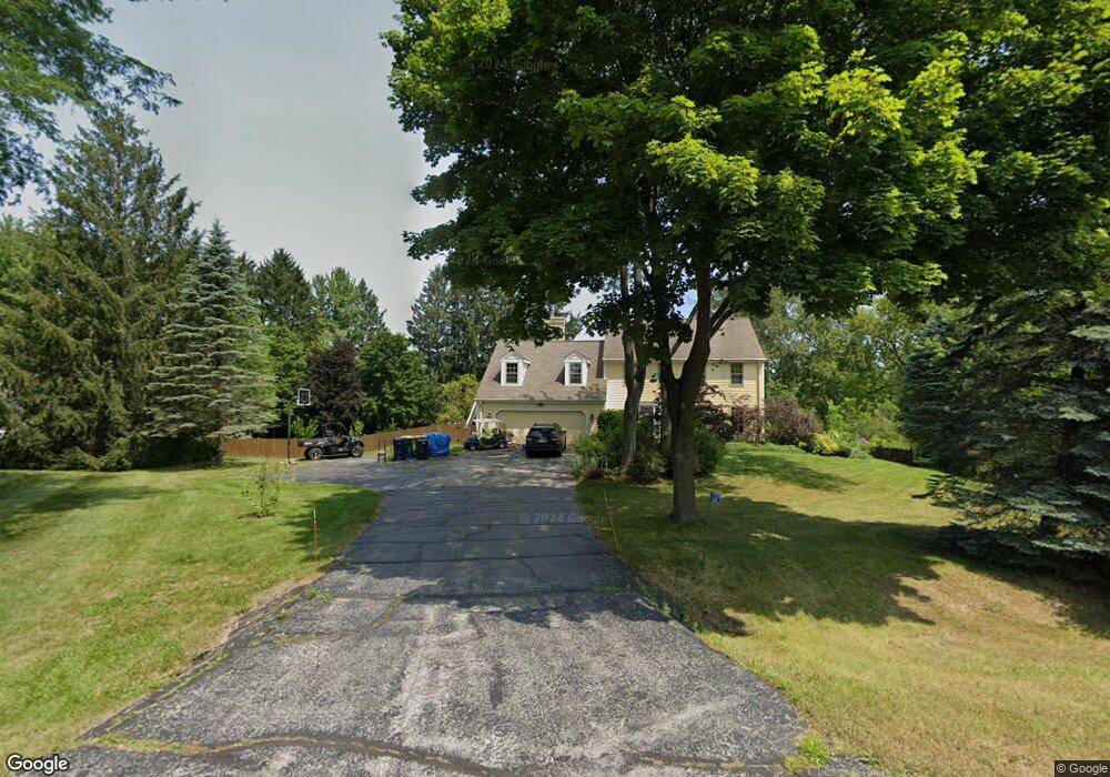
1660 Summit Dr Cedarburg, WI 53012
Estimated Value: $771,000 - $959,000
--
Bed
--
Bath
--
Sq Ft
1.86
Acres
About This Home
This home is located at 1660 Summit Dr, Cedarburg, WI 53012 and is currently estimated at $872,754. 1660 Summit Dr is a home located in Ozaukee County with nearby schools including Cedarburg High School.
Ownership History
Date
Name
Owned For
Owner Type
Purchase Details
Closed on
Mar 9, 2015
Sold by
Locatelli James D
Bought by
Plunk William P and Plunk Jami
Current Estimated Value
Home Financials for this Owner
Home Financials are based on the most recent Mortgage that was taken out on this home.
Original Mortgage
$416,500
Outstanding Balance
$318,525
Interest Rate
3.64%
Mortgage Type
New Conventional
Estimated Equity
$554,229
Purchase Details
Closed on
Apr 22, 2014
Sold by
Pyles Robert B and Pyles Betty D
Bought by
Locatelli James D and Lamb Lisa E
Home Financials for this Owner
Home Financials are based on the most recent Mortgage that was taken out on this home.
Original Mortgage
$709,985
Interest Rate
4.41%
Mortgage Type
Purchase Money Mortgage
Create a Home Valuation Report for This Property
The Home Valuation Report is an in-depth analysis detailing your home's value as well as a comparison with similar homes in the area
Home Values in the Area
Average Home Value in this Area
Purchase History
| Date | Buyer | Sale Price | Title Company |
|---|---|---|---|
| Plunk William P | -- | -- | |
| Locatelli James D | $670,000 | None Available |
Source: Public Records
Mortgage History
| Date | Status | Borrower | Loan Amount |
|---|---|---|---|
| Open | Plunk William P | $416,500 | |
| Previous Owner | Locatelli James D | $709,985 |
Source: Public Records
Tax History Compared to Growth
Tax History
| Year | Tax Paid | Tax Assessment Tax Assessment Total Assessment is a certain percentage of the fair market value that is determined by local assessors to be the total taxable value of land and additions on the property. | Land | Improvement |
|---|---|---|---|---|
| 2024 | $7,218 | $712,300 | $154,300 | $558,000 |
| 2023 | $6,675 | $712,300 | $154,300 | $558,000 |
| 2022 | $5,520 | $422,900 | $146,900 | $276,000 |
| 2021 | $5,479 | $422,900 | $146,900 | $276,000 |
| 2020 | $5,883 | $422,900 | $146,900 | $276,000 |
| 2019 | $5,982 | $422,900 | $146,900 | $276,000 |
| 2018 | $5,668 | $422,900 | $146,900 | $276,000 |
| 2017 | $5,533 | $422,900 | $146,900 | $276,000 |
| 2016 | $5,627 | $422,900 | $146,900 | $276,000 |
| 2015 | $5,710 | $422,900 | $146,900 | $276,000 |
| 2014 | -- | $422,900 | $146,900 | $276,000 |
| 2013 | $6,084 | $422,900 | $146,900 | $276,000 |
Source: Public Records
Map
Nearby Homes
- 11012 Cedar Creek Rd
- 10606 Robinwood Ct
- Lt2 Pleasant Valley Rd
- 2088 Washington Ave
- 1640 Skyline Dr
- 1810 Washington Ave
- 1935 Blacksmith Rd
- 1626 Fox Hollow Ln
- 10512 Bridge St
- 721 County Highway Nn
- 7918 Pleasant Valley Rd
- 2032 Covered Bridge Rd
- N114W7191 Oakmont Dr
- W72N1047 Hampton Ave
- W68N921 Washington Ave
- N105W6695 Stone Lake Cir Unit 5
- N106W6600 Stone Lake Cir Unit 9
- N106W6590 Stone Lake Cir Unit 10
- N105W6431 Stone Lake Cir Unit 32
- 5043 Fairy Chasm Rd