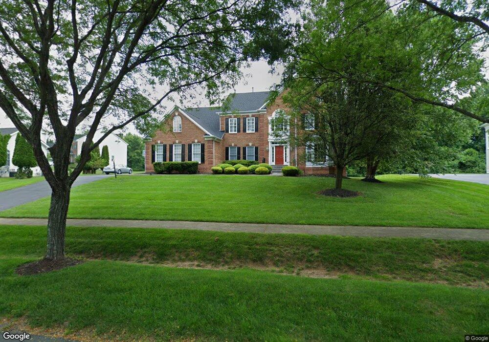
16609 Sea Island Ct Silver Spring, MD 20905
Estimated Value: $1,184,000 - $1,248,518
--
Bed
5
Baths
5,330
Sq Ft
$229/Sq Ft
Est. Value
About This Home
This home is located at 16609 Sea Island Ct, Silver Spring, MD 20905 and is currently estimated at $1,218,630, approximately $228 per square foot. 16609 Sea Island Ct is a home located in Montgomery County with nearby schools including Rogers Early Elementary School, Dr. Charles R. Drew Elementary School, and Manton Consolidated Middle School.
Ownership History
Date
Name
Owned For
Owner Type
Purchase Details
Closed on
Aug 21, 2024
Sold by
Pinckney Michael A and Pinckney Sherdine
Bought by
Pinckney Family Trust and Pinckney
Current Estimated Value
Purchase Details
Closed on
May 27, 1999
Sold by
Nvr Inc
Bought by
Pinckney Michael A and Pinckney S
Create a Home Valuation Report for This Property
The Home Valuation Report is an in-depth analysis detailing your home's value as well as a comparison with similar homes in the area
Home Values in the Area
Average Home Value in this Area
Purchase History
| Date | Buyer | Sale Price | Title Company |
|---|---|---|---|
| Pinckney Family Trust | -- | None Listed On Document | |
| Pinckney Family Trust | -- | None Listed On Document | |
| Pinckney Michael A | $527,084 | -- |
Source: Public Records
Tax History Compared to Growth
Tax History
| Year | Tax Paid | Tax Assessment Tax Assessment Total Assessment is a certain percentage of the fair market value that is determined by local assessors to be the total taxable value of land and additions on the property. | Land | Improvement |
|---|---|---|---|---|
| 2025 | $11,674 | $1,053,733 | -- | -- |
| 2024 | $11,674 | $963,367 | $0 | $0 |
| 2023 | $11,296 | $873,000 | $378,800 | $494,200 |
| 2022 | $9,387 | $865,633 | $0 | $0 |
| 2021 | $4,621 | $858,267 | $0 | $0 |
| 2020 | $4,567 | $850,900 | $420,900 | $430,000 |
| 2019 | $9,113 | $850,900 | $420,900 | $430,000 |
| 2018 | $9,122 | $850,900 | $420,900 | $430,000 |
| 2017 | $9,596 | $877,800 | $0 | $0 |
| 2016 | -- | $877,800 | $0 | $0 |
| 2015 | $8,922 | $877,800 | $0 | $0 |
| 2014 | $8,922 | $896,700 | $0 | $0 |
Source: Public Records
Map
Nearby Homes
- 1305 Magnolia Rd
- 550 Bryants Nursery Rd
- 401 Bryants Nursery Rd
- 15801 New Hampshire Ave
- 16110 Drayton Farm Dr
- 900 Tucker Ln
- 15408 Valencia St
- 1513 Rainbow Dr
- 1325 Patuxent Dr
- 17524 Shenandoah Ct
- 17731 Striley Dr
- 15325 Holly Grove Rd
- 15417 Aylesbury St
- 15222 Centergate Dr
- 202 Ashton Market Alley
- 15533 Thompson Rd
- 14820 Windmill Terrace
- 211 Olney Sandy Spring Rd
- 2307 Spencerville Rd
- 1913 Hopefield Rd
- 16607 Sea Island Ct
- 16611 Sea Island Ct
- 16613 Sea Island Ct
- 16608 Sea Island Ct
- 16605 Sea Island Ct
- 16610 Sea Island Ct
- 16610 Sea Island Ct
- 703 Firestone Dr
- 703 Firestone Dr
- 16612 Sea Island Ct
- 16612 Sea Island Ct
- 16604 Sea Island Ct
- 16603 Sea Island Ct
- 16600 Sea Island Ct
- 705 Firestone Dr
- 16600 Sea Island Ct
- 705 Firestone Dr
- 707 Firestone Dr
- 16601 Sea Island Ct
- 709 Firestone Dr