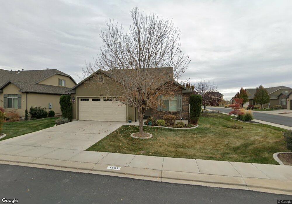
1663 W 480 N Lindon, UT 84042
Estimated Value: $538,000 - $630,000
2
Beds
3
Baths
2,339
Sq Ft
$252/Sq Ft
Est. Value
About This Home
This home is located at 1663 W 480 N, Lindon, UT 84042 and is currently estimated at $590,502, approximately $252 per square foot. 1663 W 480 N is a home located in Utah County with nearby schools including Lindon Elementary School, Oak Canyon Junior High School, and Pleasant Grove High School.
Ownership History
Date
Name
Owned For
Owner Type
Purchase Details
Closed on
Jul 19, 2019
Sold by
Stone John N
Bought by
Stone John N and The John N Stone Family Living
Current Estimated Value
Purchase Details
Closed on
Jul 18, 2019
Sold by
Vincent Clair F and The Clair F Vincent Revocable
Bought by
Stone John N
Purchase Details
Closed on
May 16, 2018
Sold by
Swain Marlene H and Swain Von G
Bought by
Vincent Clair
Purchase Details
Closed on
May 15, 2018
Sold by
Vincent Claie
Bought by
Vincent Clair F and The Clair F Vincent Revocable
Purchase Details
Closed on
Sep 4, 2013
Sold by
Swain Marlene H
Bought by
Swain Marlene and The G Von And Marlene H Swain
Purchase Details
Closed on
Aug 15, 2013
Sold by
Lindon Creekside Llc
Bought by
Swain Marlene
Create a Home Valuation Report for This Property
The Home Valuation Report is an in-depth analysis detailing your home's value as well as a comparison with similar homes in the area
Home Values in the Area
Average Home Value in this Area
Purchase History
| Date | Buyer | Sale Price | Title Company |
|---|---|---|---|
| Stone John N | -- | Access Title Company | |
| Stone John N | -- | First American | |
| Vincent Clair | -- | Recorded For Title Guarantee | |
| Vincent Clair F | -- | Accommodation | |
| Swain Marlene | -- | United Title Services | |
| Swain Marlene | -- | United Title Services |
Source: Public Records
Tax History
| Year | Tax Paid | Tax Assessment Tax Assessment Total Assessment is a certain percentage of the fair market value that is determined by local assessors to be the total taxable value of land and additions on the property. | Land | Improvement |
|---|---|---|---|---|
| 2025 | $2,520 | $292,490 | -- | -- |
| 2024 | $2,520 | $310,200 | $0 | $0 |
| 2023 | $2,356 | $311,465 | $0 | $0 |
| 2022 | $2,321 | $296,450 | $0 | $0 |
| 2021 | $1,867 | $359,500 | $135,000 | $224,500 |
| 2020 | $1,897 | $359,500 | $135,000 | $224,500 |
| 2019 | $1,818 | $359,500 | $135,000 | $224,500 |
| 2018 | $1,929 | $359,500 | $135,000 | $224,500 |
| 2017 | $1,896 | $189,475 | $0 | $0 |
| 2016 | $1,823 | $168,465 | $0 | $0 |
| 2015 | -- | $159,500 | $0 | $0 |
| 2014 | $1,773 | $153,450 | $0 | $0 |
Source: Public Records
Map
Nearby Homes
- 1596 W 480 N
- 347 N Maple Shade Ln
- 1437 W Stable St
- 264 N Old Farm Ln
- 611 N Briarwood Ln
- 578 N Briarwood Ln
- 573 N Sweet Corn Ln
- 574 N Cornstalk Ln
- 1277 W Sweet Corn Ln
- 557 N Buffalo Grass Ln
- 564 N Buffalo Grass Ln Unit 1250
- 574 N Buffalo Grass Ln
- 554 N Buffalo Grass Ln
- 566 N Buffalo Grass Ln
- 576 N Buffalo Grass Ln
- 556 N Buffalo Grass Ln
- 588 N Buffalo Grass Ln
- 568 N Buffalo Grass Ln
- 578 N Buffalo Grass Ln
- 590 N Buffalo Grass Ln
- 1663 W 480 N Unit 33
- 1647 W 480 N Unit 30
- 1647 W 480 N Unit 34
- 1664 W 430 N
- 1629 W 480 N Unit 35
- 1648 W 430 N
- 469 N 1670 W
- 1624 W 430 N
- 457 N 1670 W
- 1617 W 480 N Unit 36
- 445 N 1670 W
- 1610 W 430 N Unit 51
- 1605 W 480 N Unit 37
- 433 N 1670 W
- 1612 W 480 N
- 1612 W 480 N Unit 1
- 1598 W 430 N
- 1657 W 430 N
- 1667 W 430 N
- 1627 W 430 N Unit 25
Your Personal Tour Guide
Ask me questions while you tour the home.