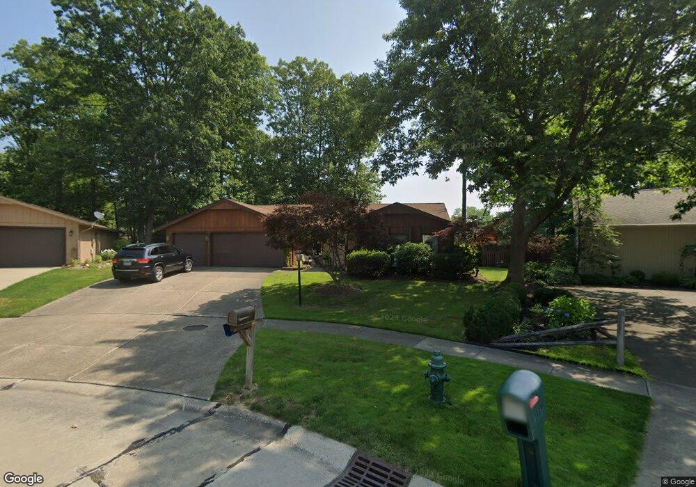
16638 Aspen Cir Strongsville, OH 44136
Estimated Value: $357,000 - $391,000
3
Beds
2
Baths
2,346
Sq Ft
$159/Sq Ft
Est. Value
About This Home
This home is located at 16638 Aspen Cir, Strongsville, OH 44136 and is currently estimated at $372,195, approximately $158 per square foot. 16638 Aspen Cir is a home located in Cuyahoga County with nearby schools including Strongsville High School, Saint Ambrose Catholic School, and Sts Joseph & John Interparochial School.
Ownership History
Date
Name
Owned For
Owner Type
Purchase Details
Closed on
Sep 22, 2021
Bought by
Felice Betty
Current Estimated Value
Purchase Details
Closed on
Mar 25, 1991
Sold by
Felice Michael
Bought by
Felice Betty L
Purchase Details
Closed on
Nov 28, 1978
Bought by
Felice Michael
Purchase Details
Closed on
Jun 19, 1978
Bought by
Production Homes Inc
Purchase Details
Closed on
Jan 1, 1978
Bought by
Northeast Land Co
Create a Home Valuation Report for This Property
The Home Valuation Report is an in-depth analysis detailing your home's value as well as a comparison with similar homes in the area
Home Values in the Area
Average Home Value in this Area
Purchase History
| Date | Buyer | Sale Price | Title Company |
|---|---|---|---|
| Felice Betty | -- | -- | |
| Felice Betty L | -- | -- | |
| Felice Michael | -- | -- | |
| Production Homes Inc | $34,000 | -- | |
| Northeast Land Co | -- | -- |
Source: Public Records
Tax History Compared to Growth
Tax History
| Year | Tax Paid | Tax Assessment Tax Assessment Total Assessment is a certain percentage of the fair market value that is determined by local assessors to be the total taxable value of land and additions on the property. | Land | Improvement |
|---|---|---|---|---|
| 2024 | $4,317 | $101,745 | $21,910 | $79,835 |
| 2023 | $4,799 | $85,820 | $22,190 | $63,630 |
| 2022 | $4,791 | $85,820 | $22,190 | $63,630 |
| 2021 | $4,753 | $85,820 | $22,190 | $63,630 |
| 2020 | $4,294 | $70,350 | $18,200 | $52,150 |
| 2019 | $4,168 | $201,000 | $52,000 | $149,000 |
| 2018 | $3,783 | $70,350 | $18,200 | $52,150 |
| 2017 | $3,662 | $63,950 | $14,420 | $49,530 |
| 2016 | $3,632 | $63,950 | $14,420 | $49,530 |
| 2015 | $3,683 | $63,950 | $14,420 | $49,530 |
| 2014 | $3,683 | $63,950 | $14,420 | $49,530 |
Source: Public Records
Map
Nearby Homes
- 16711 Beech Cir
- 17745 Brick Mill Run
- 16486 S Red Rock Dr
- 18229 Howe Rd
- 15772 Boston Rd
- 17130 Golden Star Dr
- 19364 Ridgeline Ct
- 15604-REAR Boston Rd
- 97 Weathervane Ln
- 19694 Benbow Rd
- 19740 Benbow Rd
- 14985 Camden Cir
- 15188 Trails Landing
- 17159 Turkey Meadow Ln
- 17682 Drake Rd
- 18411 Yorktown Oval
- 18987 Laurell Cir
- 159 Sunflower Dr
- 17934 Cambridge Oval
- 18294 Drake Rd
- 16670 Aspen Cir
- 16631 Aspen Cir
- 18922 Bears Paw Ln
- 18964 Bears Paw Ln
- 16575 Falmouth Dr
- 16633 Falmouth Dr
- 16702 Aspen Cir
- 16669 Falmouth Dr
- 19006 Bears Paw Ln
- 16663 Aspen Cir
- 16527 Falmouth Dr
- 16687 Falmouth Dr
- 16695 Aspen Cir
- 16734 Aspen Cir
- 19048 Bears Paw Ln
- 16721 Falmouth Dr
- 16664 Beech Cir
- 16727 Aspen Cir
- 16766 Aspen Cir
- 19090 Bears Paw Ln