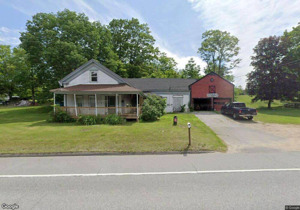
1666 Federal Rd Livermore, ME 04253
Estimated Value: $198,239 - $298,000
3
Beds
2
Baths
1,040
Sq Ft
$221/Sq Ft
Est. Value
About This Home
This home is located at 1666 Federal Rd, Livermore, ME 04253 and is currently estimated at $229,810, approximately $220 per square foot. 1666 Federal Rd is a home located in Androscoggin County with nearby schools including Spruce Mountain Primary School, Spruce Mountain Elementary School, and Spruce Mountain Middle School.
Ownership History
Date
Name
Owned For
Owner Type
Purchase Details
Closed on
Jul 13, 2005
Sold by
Boyington Richard B and Boyington Gail M
Bought by
Richards Martin and Richards Tracy
Current Estimated Value
Home Financials for this Owner
Home Financials are based on the most recent Mortgage that was taken out on this home.
Original Mortgage
$65,550
Outstanding Balance
$40,176
Interest Rate
8.7%
Mortgage Type
Adjustable Rate Mortgage/ARM
Estimated Equity
$189,634
Create a Home Valuation Report for This Property
The Home Valuation Report is an in-depth analysis detailing your home's value as well as a comparison with similar homes in the area
Home Values in the Area
Average Home Value in this Area
Purchase History
| Date | Buyer | Sale Price | Title Company |
|---|---|---|---|
| Richards Martin | -- | -- |
Source: Public Records
Mortgage History
| Date | Status | Borrower | Loan Amount |
|---|---|---|---|
| Open | Richards Martin | $65,550 |
Source: Public Records
Tax History Compared to Growth
Tax History
| Year | Tax Paid | Tax Assessment Tax Assessment Total Assessment is a certain percentage of the fair market value that is determined by local assessors to be the total taxable value of land and additions on the property. | Land | Improvement |
|---|---|---|---|---|
| 2025 | $1,999 | $105,770 | $28,256 | $77,514 |
| 2024 | $1,809 | $105,770 | $28,256 | $77,514 |
| 2023 | $1,719 | $105,770 | $28,256 | $77,514 |
| 2022 | $1,692 | $105,770 | $28,256 | $77,514 |
| 2021 | $1,692 | $105,770 | $28,256 | $77,514 |
| 2020 | $1,613 | $105,770 | $28,256 | $77,514 |
| 2019 | $1,350 | $83,071 | $24,256 | $58,815 |
| 2018 | $1,329 | $83,071 | $24,256 | $58,815 |
| 2017 | $1,362 | $83,071 | $24,256 | $58,815 |
| 2016 | $1,329 | $83,071 | $24,256 | $58,815 |
| 2015 | $1,329 | $83,071 | $24,256 | $58,815 |
| 2014 | $1,180 | $83,071 | $24,256 | $58,815 |
Source: Public Records
Map
Nearby Homes
- 1671 Federal Rd
- 51 Church St
- 137 Canton Rd
- 1785 Federal Rd
- Lot 45-8 Wyatt's Way
- 62 Norton Rd
- 35 Mason Rd
- 2539 Auburn Rd
- 1081 Federal Rd
- Lot16 Torrey Hill Rd
- 726 Jewett Hill Rd
- 167 Howes Corner Rd
- 61 Rocky Mountain Way
- Lot C Fern Way
- 21 Stonewall Dr
- 309 Strickland Ferry Rd
- 574 Howes Corner Rd
- Lot 9B Pulsifer Rd
- 9 Pulsifer Rd
- 1 Lake View Dr
- 1674 Federal Rd
- 19 Butterhill Rd
- 1679 Federal Rd
- 7 Butterhill Rd
- 20 Butter Hill Rd
- 20 Butterhill Rd
- 31 Butterhill Rd
- 234 Butter Hill Rd
- 1734 Federal Rd
- 43 Butter Hill Rd
- 1695 Federal Rd
- 6 Bear Mountain Rd
- 1635 Federal Rd
- 48 Canton Rd
- 52 Butter Hill Rd
- 34 Canton Rd
- 61 Butter Hill Rd
- 25 Bryant Rd
- 1622 Federal Rd
- 40 Deer Run