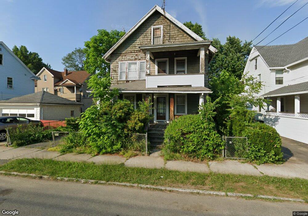
167 Commonwealth Ave Unit 169 Springfield, MA 01108
Forest Park NeighborhoodEstimated Value: $297,769 - $310,000
6
Beds
2
Baths
2,438
Sq Ft
$124/Sq Ft
Est. Value
About This Home
This home is located at 167 Commonwealth Ave Unit 169, Springfield, MA 01108 and is currently estimated at $301,192, approximately $123 per square foot. 167 Commonwealth Ave Unit 169 is a home located in Hampden County with nearby schools including Alice B. Beal Elementary School, Forest Park Middle School, and High School Of Commerce.
Ownership History
Date
Name
Owned For
Owner Type
Purchase Details
Closed on
Jun 9, 1997
Sold by
Calabrese Italia
Bought by
Lavalette Patricia
Current Estimated Value
Home Financials for this Owner
Home Financials are based on the most recent Mortgage that was taken out on this home.
Original Mortgage
$36,850
Outstanding Balance
$5,273
Interest Rate
7.98%
Mortgage Type
Purchase Money Mortgage
Estimated Equity
$295,919
Create a Home Valuation Report for This Property
The Home Valuation Report is an in-depth analysis detailing your home's value as well as a comparison with similar homes in the area
Home Values in the Area
Average Home Value in this Area
Purchase History
| Date | Buyer | Sale Price | Title Company |
|---|---|---|---|
| Lavalette Patricia | $55,000 | -- |
Source: Public Records
Mortgage History
| Date | Status | Borrower | Loan Amount |
|---|---|---|---|
| Open | Lavalette Patricia | $14,075 | |
| Closed | Lavalette Patricia | $17,400 | |
| Open | Lavalette Patricia | $36,850 |
Source: Public Records
Tax History
| Year | Tax Paid | Tax Assessment Tax Assessment Total Assessment is a certain percentage of the fair market value that is determined by local assessors to be the total taxable value of land and additions on the property. | Land | Improvement |
|---|---|---|---|---|
| 2025 | $2,440 | $155,600 | $36,800 | $118,800 |
| 2024 | $2,557 | $159,200 | $36,800 | $122,400 |
| 2023 | $2,401 | $140,800 | $35,100 | $105,700 |
| 2022 | $2,112 | $112,200 | $35,100 | $77,100 |
| 2021 | $2,226 | $117,800 | $31,900 | $85,900 |
| 2020 | $2,262 | $115,800 | $31,900 | $83,900 |
| 2019 | $2,368 | $120,300 | $31,900 | $88,400 |
| 2018 | $2,175 | $110,500 | $31,900 | $78,600 |
| 2017 | $2,129 | $108,300 | $31,900 | $76,400 |
| 2016 | $1,866 | $94,900 | $31,900 | $63,000 |
| 2015 | $1,784 | $90,700 | $31,900 | $58,800 |
Source: Public Records
Map
Nearby Homes
- 35 Carlton St
- 144 Washington St
- 134-136 Woodlawn St
- 58 Appleton St
- 52 Orlando St
- 179 Carver St
- 132 Carroll St
- 27 Ormond St
- 104 Appleton St
- 137 Carroll St
- 42 Carroll St
- 914-916 Belmont Ave
- 12 Carroll St
- 53 Texel Dr
- 22 Eleanor Rd
- 33-35 Ruskin St
- 88 Brunswick St
- 46 Eckington St
- 38 Manchester Terrace
- 854-856 Sumner Ave
- 173 Commonwealth Ave
- 67 Washington St Unit 69
- 73 Washington St Unit 75
- 73-75 Washington St
- 61 Washington St Unit 63
- 177 Commonwealth Ave Unit 179
- 12 Carver St Unit 14
- 12-14 Carver St
- 79 Washington St
- 168 Commonwealth Ave
- 183 Commonwealth Ave
- 18 Carver St Unit 20
- 18-20 Carver St
- 172-174 Commonwealth Ave
- 172 Commonwealth Ave Unit 174
- 162 Commonwealth Ave Unit 164
- 162-164 Commonweatlh Ave
- 162-164 Commonwealth Ave
- 0 Washington St
- 49 Washington St Unit 51
Your Personal Tour Guide
Ask me questions while you tour the home.