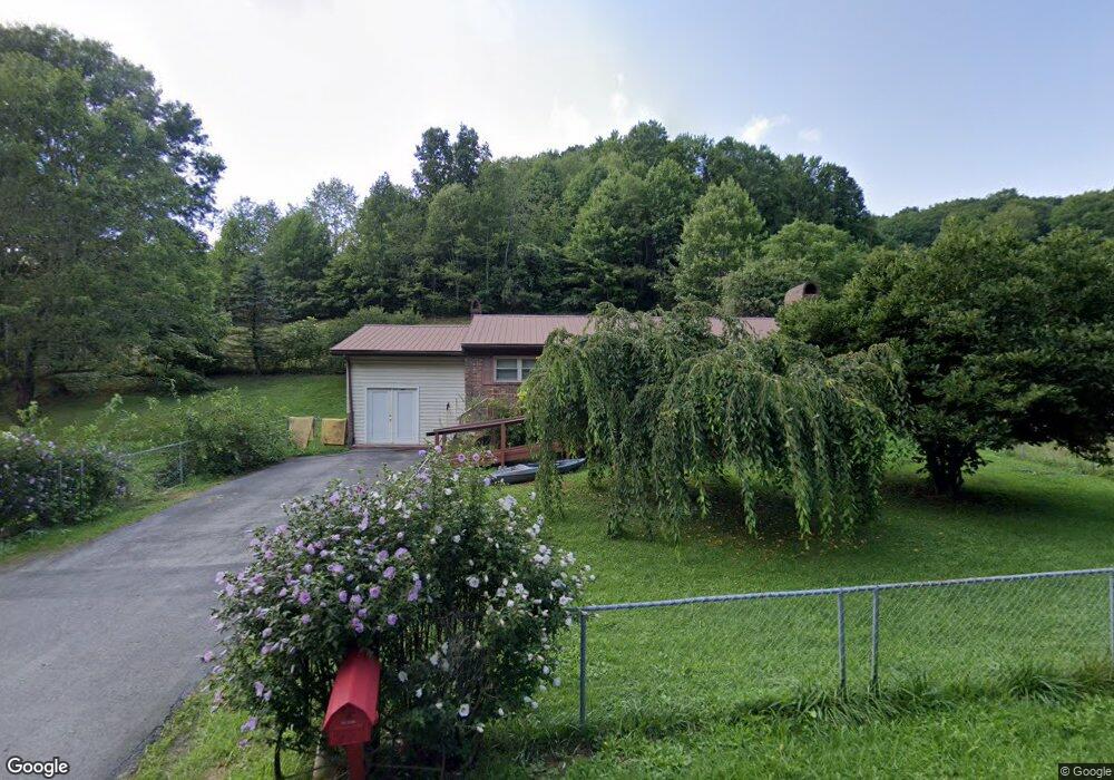
167 Lick Branch Rd Cedar Bluff, VA 24609
Estimated Value: $144,000 - $191,000
2
Beds
2
Baths
1,344
Sq Ft
$119/Sq Ft
Est. Value
About This Home
This home is located at 167 Lick Branch Rd, Cedar Bluff, VA 24609 and is currently estimated at $160,136, approximately $119 per square foot. 167 Lick Branch Rd is a home located in Tazewell County.
Ownership History
Date
Name
Owned For
Owner Type
Purchase Details
Closed on
Jun 27, 2023
Sold by
Looney Janet Susan
Bought by
Baldwin Royce A and Boyd Inis Nadine
Current Estimated Value
Home Financials for this Owner
Home Financials are based on the most recent Mortgage that was taken out on this home.
Original Mortgage
$131,313
Outstanding Balance
$127,380
Interest Rate
6.39%
Mortgage Type
New Conventional
Estimated Equity
$32,756
Purchase Details
Closed on
May 3, 2007
Sold by
Boyd Willard Pierce and Boyd Inis Nadine
Bought by
Looney Janet Susan
Create a Home Valuation Report for This Property
The Home Valuation Report is an in-depth analysis detailing your home's value as well as a comparison with similar homes in the area
Purchase History
| Date | Buyer | Sale Price | Title Company |
|---|---|---|---|
| Baldwin Royce A | $130,000 | None Listed On Document | |
| Looney Janet Susan | -- | -- |
Source: Public Records
Mortgage History
| Date | Status | Borrower | Loan Amount |
|---|---|---|---|
| Open | Baldwin Royce A | $131,313 |
Source: Public Records
Tax History
| Year | Tax Paid | Tax Assessment Tax Assessment Total Assessment is a certain percentage of the fair market value that is determined by local assessors to be the total taxable value of land and additions on the property. | Land | Improvement |
|---|---|---|---|---|
| 2025 | -- | $123,800 | $25,000 | $98,800 |
| 2024 | -- | $123,800 | $25,000 | $98,800 |
| 2023 | $502 | $86,500 | $12,800 | $73,700 |
| 2022 | $502 | $86,500 | $12,800 | $73,700 |
| 2021 | $502 | $86,500 | $12,800 | $73,700 |
| 2020 | $502 | $86,500 | $12,800 | $73,700 |
| 2019 | $502 | $86,500 | $12,800 | $73,700 |
| 2018 | $479 | $86,500 | $12,800 | $73,700 |
| 2017 | $479 | $87,100 | $12,800 | $74,300 |
| 2016 | -- | $87,100 | $12,800 | $74,300 |
| 2015 | -- | $87,100 | $12,800 | $74,300 |
| 2014 | -- | $87,100 | $12,800 | $74,300 |
| 2013 | -- | $87,100 | $12,800 | $74,300 |
Source: Public Records
Map
Nearby Homes
- TBD Cliff Rd
- 624 Baptist Valley Rd
- 386 Keen Rd
- 3406 Baptist Valley Rd
- 220 220 Easy St
- 18537 Governor G C Peery Hwy
- 18466 Governor George C Peery Hwy
- 4330 Ravens Nest Branch Rd
- TBD Lickbranch Rd
- 5910 Dry Fork Rd
- TBD Dry Fork Rd
- 149 Cochran Hollow Rd
- 955 Wakefield Dr
- TBD Green Acres Rd
- 2906 Pounding Mill Branch Rd
- TBD Bandy Rd Whitaker Ridge Area
- 1532 Indian Creek Rd
- 160 Riverbend Ln
- 153 Ashley St
- 6426 Baptist Valley Rd
- 155 Lick Branch Rd
- 179 Lick Branch Rd
- 114 Snap Rd
- 117 Snap Rd
- 189 Lick Branch Rd
- 1901 Baptist Valley Rd
- 1805 Baptist Valley Rd
- 1789 Baptist Valley Rd
- 1802 Baptist Valley Rd
- 1917 Baptist Valley Rd
- 1769 Baptist Valley Rd
- 1725 Baptist Valley Rd
- 287 Lick Branch Rd
- 1836 Baptist Valley Rd
- 1804 Baptist Valley Rd
- 1904 Baptist Valley Rd
- 1852 Baptist Valley Rd
- 1820 Baptist Valley Rd
- 1758 Baptist Valley Rd
- 1703 Baptist Valley Rd
Your Personal Tour Guide
Ask me questions while you tour the home.