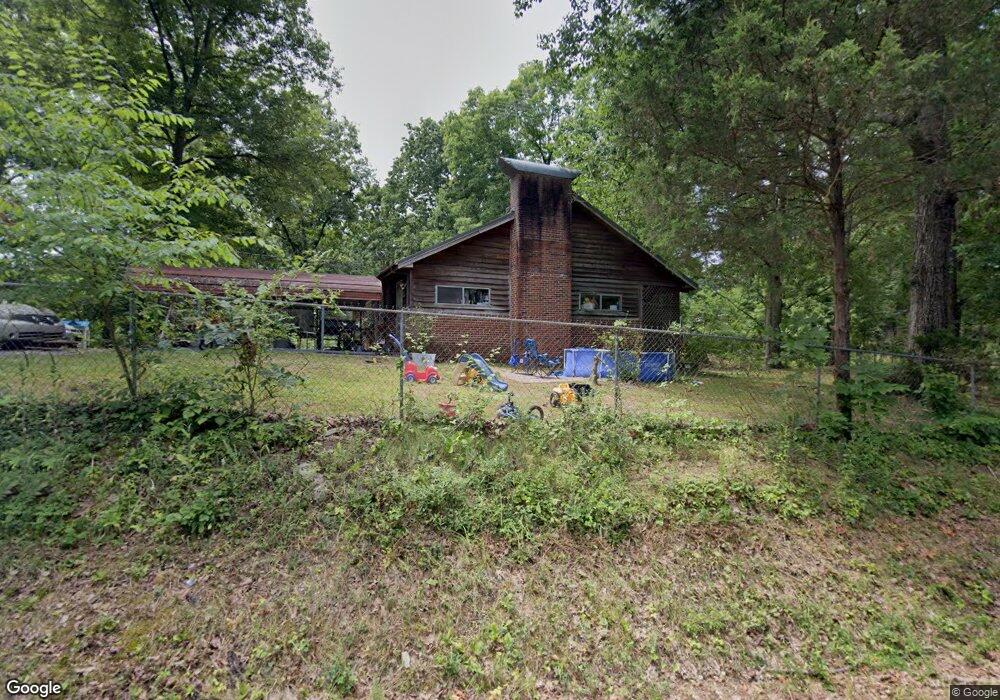
167 Orange Dr Dalton, GA 30721
Estimated Value: $187,870 - $222,000
Studio
1
Bath
1,238
Sq Ft
$166/Sq Ft
Est. Value
About This Home
This home is located at 167 Orange Dr, Dalton, GA 30721 and is currently estimated at $205,468, approximately $165 per square foot. 167 Orange Dr is a home located in Whitfield County with nearby schools including Cedar Ridge Elementary School, Eastbrook Middle School, and Southeast Whitfield County High School.
Ownership History
Date
Name
Owned For
Owner Type
Purchase Details
Closed on
Sep 3, 2014
Sold by
Biggerstaff Danyell
Bought by
Biggerstaff Clyde and Biggerstaff Danyell
Current Estimated Value
Home Financials for this Owner
Home Financials are based on the most recent Mortgage that was taken out on this home.
Original Mortgage
$35,000
Outstanding Balance
$10,684
Interest Rate
4.2%
Mortgage Type
New Conventional
Estimated Equity
$194,784
Purchase Details
Closed on
Mar 10, 2005
Sold by
Not Provided
Bought by
Biggerstaff Danyell
Purchase Details
Closed on
May 1, 1999
Bought by
Burkett Baxter J
Create a Home Valuation Report for This Property
The Home Valuation Report is an in-depth analysis detailing your home's value as well as a comparison with similar homes in the area
Purchase History
| Date | Buyer | Sale Price | Title Company |
|---|---|---|---|
| Biggerstaff Clyde | -- | -- | |
| Biggerstaff Danyell | -- | -- | |
| Burkett Baxter J | -- | -- |
Source: Public Records
Mortgage History
| Date | Status | Borrower | Loan Amount |
|---|---|---|---|
| Open | Biggerstaff Clyde | $35,000 |
Source: Public Records
Tax History
| Year | Tax Paid | Tax Assessment Tax Assessment Total Assessment is a certain percentage of the fair market value that is determined by local assessors to be the total taxable value of land and additions on the property. | Land | Improvement |
|---|---|---|---|---|
| 2025 | $1,499 | $72,362 | $6,400 | $65,962 |
| 2024 | $1,499 | $72,362 | $6,400 | $65,962 |
| 2023 | $1,000 | $41,590 | $4,494 | $37,096 |
| 2022 | $626 | $29,782 | $4,494 | $25,288 |
| 2021 | $626 | $29,782 | $4,494 | $25,288 |
| 2020 | $636 | $29,782 | $4,494 | $25,288 |
| 2019 | $641 | $29,782 | $4,494 | $25,288 |
| 2018 | $646 | $29,782 | $4,494 | $25,288 |
| 2017 | $646 | $29,782 | $4,494 | $25,288 |
| 2016 | $566 | $27,537 | $4,494 | $23,043 |
| 2014 | $542 | $27,537 | $4,494 | $23,043 |
| 2013 | -- | $27,536 | $4,494 | $23,042 |
Source: Public Records
Map
Nearby Homes
- 0 Old Grade Rd
- 3407 Airport Rd SE
- 165 Stanley St Unit 560-561
- 216 Scobie Ave
- 129 Hillwood Dr
- 117 Wooten Dr
- 119 Wooten Dr
- 118 Hill Rd
- 0 Tibbs Bridge Rd SE
- 213 Nashville St
- 2905 E Walnut Ave
- 119 Eugenia Dr
- 143 Staten St
- 121 Eugenia Dr
- 359 Pacer Ln Unit 4
- 01 Headrick Cir SE
- 112 Gillespie Dr
- 3657 Airport Rd
- 00 Hill Rd
- 115 Zell Dr
- 148 Orange Dr
- 164 Orange Dr
- 182 Orange Dr
- 150 Orange Dr
- 162 Orange Dr
- 162 Orange Dr
- 199 Orange Dr
- 198 Orange Dr
- 127 W Talon Way
- 153 Kitchens Dr
- 149 Kitchens Dr
- 130 Orange Dr
- 129 Orange Dr
- 468 Robinwood Cir
- 472 Robinwood Cir
- 450 Robinwood Cir
- 141 Kitchens Dr
- 125 Orange Dr
- 448 Robinwood Cir
- 447 Robinwood Cir
Your Personal Tour Guide
Ask me questions while you tour the home.