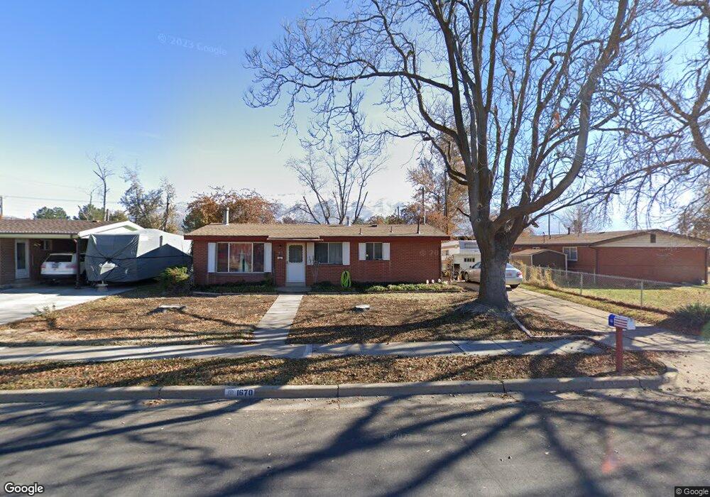
1670 Alder St Layton, UT 84041
Estimated Value: $340,000 - $370,600
3
Beds
1
Bath
1,025
Sq Ft
$348/Sq Ft
Est. Value
About This Home
This home is located at 1670 Alder St, Layton, UT 84041 and is currently estimated at $357,150, approximately $348 per square foot. 1670 Alder St is a home located in Davis County with nearby schools including Lincoln Elementary School, North Layton Junior High School, and Northridge High School.
Ownership History
Date
Name
Owned For
Owner Type
Purchase Details
Closed on
Jan 11, 2008
Sold by
Koski William R
Bought by
Koski William R and Koski Michael Patrick
Current Estimated Value
Purchase Details
Closed on
Dec 14, 1999
Sold by
Elmer Theodore K and Bain Reva
Bought by
Koski William R
Home Financials for this Owner
Home Financials are based on the most recent Mortgage that was taken out on this home.
Original Mortgage
$87,850
Outstanding Balance
$26,963
Interest Rate
7.82%
Mortgage Type
Purchase Money Mortgage
Estimated Equity
$330,187
Create a Home Valuation Report for This Property
The Home Valuation Report is an in-depth analysis detailing your home's value as well as a comparison with similar homes in the area
Home Values in the Area
Average Home Value in this Area
Purchase History
| Date | Buyer | Sale Price | Title Company |
|---|---|---|---|
| Koski William R | -- | None Available | |
| Koski William R | -- | Backman Stewart Title Servic |
Source: Public Records
Mortgage History
| Date | Status | Borrower | Loan Amount |
|---|---|---|---|
| Open | Koski William R | $87,850 |
Source: Public Records
Tax History Compared to Growth
Tax History
| Year | Tax Paid | Tax Assessment Tax Assessment Total Assessment is a certain percentage of the fair market value that is determined by local assessors to be the total taxable value of land and additions on the property. | Land | Improvement |
|---|---|---|---|---|
| 2025 | $1,499 | $157,300 | $100,178 | $57,122 |
| 2024 | $1,472 | $155,651 | $116,837 | $38,814 |
| 2023 | $1,422 | $265,000 | $139,920 | $125,080 |
| 2022 | $1,413 | $143,000 | $73,674 | $69,326 |
| 2021 | $1,312 | $198,000 | $102,544 | $95,456 |
| 2020 | $1,195 | $173,000 | $86,619 | $86,381 |
| 2019 | $1,213 | $172,000 | $82,576 | $89,424 |
| 2018 | $1,060 | $151,000 | $82,576 | $68,424 |
| 2016 | $925 | $67,981 | $26,164 | $41,817 |
| 2015 | $874 | $60,941 | $26,164 | $34,777 |
| 2014 | $789 | $56,268 | $26,164 | $30,104 |
| 2013 | -- | $71,217 | $24,816 | $46,401 |
Source: Public Records
Map
Nearby Homes
- 398 Paul Ave
- 1715 N Alder St
- 1837 N 440 W
- 1490 N 175 W
- 1908 N 200 W
- 1583 N 25 E
- 2053 Evans Cove Loop Unit 39
- 2044 Evans Cove Loop
- 2048 Evans Cove Loop
- 103 W 1275 N
- 506 W 2200 N
- 2211 N 525 W
- 2248 N 500 W
- 1096 N 300 W
- 1553 N 250 E
- 9 W 2150 N
- 1500 N Angel St Unit 12
- 23 E 2150 N
- 1180 N 100 E
- 1094 N Angel St W
- 410 W Forbes St
- 410 Forbes St
- 1684 Alder St
- 1684 N Alder St
- 1675 N Hill Field Rd
- 388 Forbes St
- 1691 N Hill Field Rd
- 1698 Alder St
- 1673 Alder St
- 438 Forbes St
- 438 W Forbes St
- 1701 Alder St
- 1701 N Alder St
- 411 W Forbes St
- 1705 N Hill Field Rd
- 393 W Forbes St
- 411 Forbes St
- 1708 Alder St
- 423 W Forbes St
- 393 Forbes St