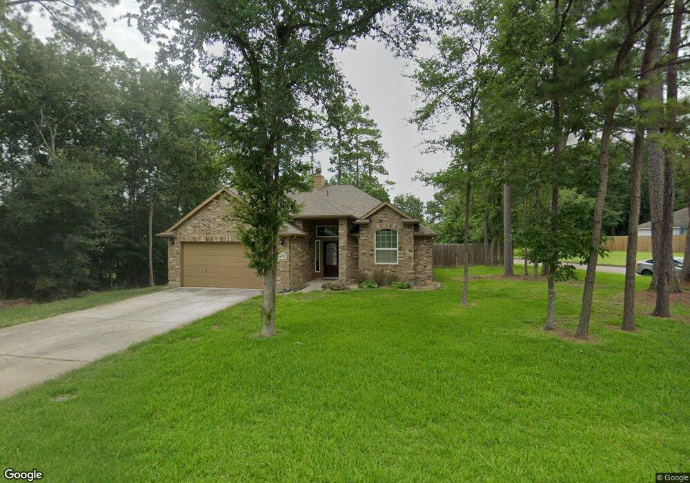
16702 Wherry Dr Crosby, TX 77532
Estimated Value: $302,000 - $369,000
3
Beds
2
Baths
1,829
Sq Ft
$177/Sq Ft
Est. Value
About This Home
This home is located at 16702 Wherry Dr, Crosby, TX 77532 and is currently estimated at $323,720, approximately $176 per square foot. 16702 Wherry Dr is a home located in Harris County with nearby schools including Crosby Elementary School, Crosby Middle School, and Crosby High School.
Ownership History
Date
Name
Owned For
Owner Type
Purchase Details
Closed on
Aug 21, 2017
Sold by
Khbm Partners Iii Ltd
Bought by
Cowan John David
Current Estimated Value
Home Financials for this Owner
Home Financials are based on the most recent Mortgage that was taken out on this home.
Original Mortgage
$227,613
Outstanding Balance
$190,283
Interest Rate
4.03%
Mortgage Type
VA
Estimated Equity
$133,437
Purchase Details
Closed on
Jul 21, 2016
Sold by
Rampart Holding Llc
Bought by
Khbm Partners Iii Ltd
Home Financials for this Owner
Home Financials are based on the most recent Mortgage that was taken out on this home.
Original Mortgage
$155,765
Interest Rate
3.54%
Purchase Details
Closed on
Oct 14, 2010
Sold by
Bell Ben J
Bought by
Newport Fund Llc
Purchase Details
Closed on
Oct 7, 2008
Sold by
Allan Edwards Builders Inc
Bought by
Crosby Independent School District
Create a Home Valuation Report for This Property
The Home Valuation Report is an in-depth analysis detailing your home's value as well as a comparison with similar homes in the area
Home Values in the Area
Average Home Value in this Area
Purchase History
| Date | Buyer | Sale Price | Title Company |
|---|---|---|---|
| Cowan John David | -- | Great American Title | |
| Khbm Partners Iii Ltd | -- | Capital Title | |
| Newport Fund Llc | -- | None Available | |
| Crosby Independent School District | $10,433 | None Available |
Source: Public Records
Mortgage History
| Date | Status | Borrower | Loan Amount |
|---|---|---|---|
| Open | Cowan John David | $227,613 | |
| Previous Owner | Khbm Partners Iii Ltd | $155,765 |
Source: Public Records
Tax History Compared to Growth
Tax History
| Year | Tax Paid | Tax Assessment Tax Assessment Total Assessment is a certain percentage of the fair market value that is determined by local assessors to be the total taxable value of land and additions on the property. | Land | Improvement |
|---|---|---|---|---|
| 2025 | $4,121 | $335,628 | $108,384 | $227,244 |
| 2024 | $4,121 | $324,977 | $96,771 | $228,206 |
| 2023 | $4,121 | $345,842 | $96,771 | $249,071 |
| 2022 | $6,788 | $312,169 | $85,159 | $227,010 |
| 2021 | $6,370 | $235,000 | $69,675 | $165,325 |
| 2020 | $6,430 | $228,000 | $61,934 | $166,066 |
| 2019 | $6,740 | $229,000 | $46,450 | $182,550 |
| 2018 | $3,378 | $204,721 | $22,170 | $182,551 |
| 2017 | $3,216 | $107,061 | $12,933 | $94,128 |
| 2016 | $389 | $12,933 | $12,933 | $0 |
| 2015 | $127 | $12,933 | $12,933 | $0 |
| 2014 | $127 | $12,933 | $12,933 | $0 |
Source: Public Records
Map
Nearby Homes
- 631 Aweigh Dr
- 812 Backstay Ct
- 16659 Bluefin St
- 16727 Camber Ct
- 731 Tarpaulin Way
- 16626 Bluefin St
- 16602 E Kingscoate Dr
- 16919 Lacing Ct
- 1103 Channels St
- 516 Aweigh Dr
- 16511 Bluefin St
- 16507 Bluefin St
- 16506 E Kingscoate Dr
- 454 Fishhawk Way
- 710 Equinox St
- 16611 Port o Call St
- 16431 Spinnaker Dr
- 439 Fishhawk Way
- 415 Binnacle Way
- 16402 Port o Call St