1671 State Ave Cincinnati, OH 45204
East Price Hill NeighborhoodHighlights
- City View
- Walnut Hills High School Rated A+
- No HOA
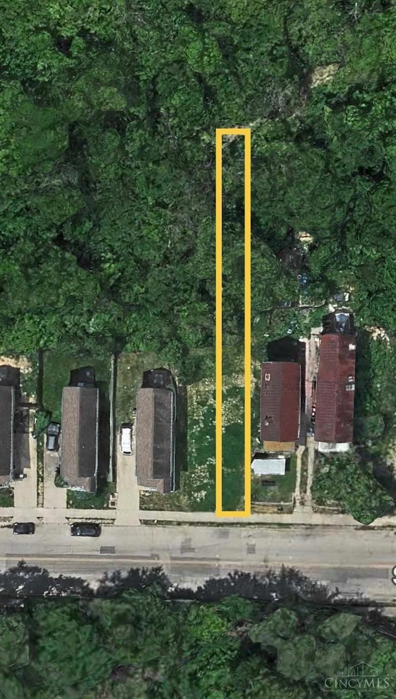
About This Lot
Vacant Lot
Property Details
Property Type
- Land
Lot Details
- 4,051 Sq Ft Lot
- Lot Dimensions are 18.1x200
- Cleared Lot
Additional Features
- City Views
- Gas Available at Street
Community Details
- No Home Owners Association
Map
Home Values in the Area
Average Home Value in this Area
Tax History
| Year | Tax Paid | Tax Assessment Tax Assessment Total Assessment is a certain percentage of the fair market value that is determined by local assessors to be the total taxable value of land and additions on the property. | Land | Improvement |
|---|---|---|---|---|
| 2025 | $75 | $1,190 | $1,190 | -- |
| 2024 | $88 | $1,190 | $1,190 | -- |
| 2023 | $88 | $1,190 | $1,190 | $0 |
| 2022 | $80 | $963 | $963 | $0 |
| 2021 | $75 | $6,535 | $963 | $5,572 |
| 2020 | $462 | $6,535 | $963 | $5,572 |
| 2019 | $506 | $6,535 | $963 | $5,572 |
| 2018 | $506 | $6,535 | $963 | $5,572 |
| 2017 | $487 | $6,535 | $963 | $5,572 |
| 2016 | $274 | $3,557 | $1,243 | $2,314 |
| 2015 | $246 | $3,557 | $1,243 | $2,314 |
| 2014 | $247 | $3,557 | $1,243 | $2,314 |
| 2013 | $257 | $3,626 | $1,267 | $2,359 |
Property History
| Date | Event | Price | List to Sale | Price per Sq Ft |
|---|---|---|---|---|
| 02/23/2026 02/23/26 | Price Changed | $4,500 | -25.0% | -- |
| 11/14/2025 11/14/25 | For Sale | $6,000 | -- | -- |
Purchase History
| Date | Type | Sale Price | Title Company |
|---|---|---|---|
| Warranty Deed | $32,000 | -- | |
| Survivorship Deed | $24,000 | -- | |
| Quit Claim Deed | -- | -- | |
| Warranty Deed | -- | -- | |
| Warranty Deed | -- | -- |
Source: MLS of Greater Cincinnati (CincyMLS)
MLS Number: 1862080
APN: 168-0002-0123
Disclaimer: Certain information contained herein is derived from information provided by parties other than Homes.com. All information provided is deemed reliable, but is not guaranteed to be accurate and should be independently verified.
![]() The data relating to real estate for sale on this website comes in part from the Broker Reciprocity programs of the MLS of Greater Cincinnati, Inc.. Those listings held by brokerage firms other than Ten-X are marked with the Broker Reciprocity logo and house icon. The properties displayed may not be all of the properties available through Broker Reciprocity.
The data relating to real estate for sale on this website comes in part from the Broker Reciprocity programs of the MLS of Greater Cincinnati, Inc.. Those listings held by brokerage firms other than Ten-X are marked with the Broker Reciprocity logo and house icon. The properties displayed may not be all of the properties available through Broker Reciprocity.
IDX information is provided exclusively for personal, non-commercial use, and may not be used for any purpose other than to identify prospective properties consumers may be interested in purchasing.
Information is deemed reliable but not guaranteed.
Ten-X does not display the entire Cincinnati MLS Broker Reciprocity™ database on this web site. The listings of some real estate brokerage firms have been excluded.
Copyright 2026, MLS of Greater Cincinnati, Inc. All rights reserved
- 1669 State Ave
- 1708 State Ave
- 1900 State Ave
- 1646 State Ave
- 1948 State Ave
- 2182 Grand Ave
- 2832 Claypole Ave
- 2173 Clara St
- 2169 Clara St
- 2165 Clara St
- 2281 Northside Ave
- 1114 Wing St
- 2227 Grand Ave
- 1699 Westwood Ave
- 2829 Glenway Ave
- 2540 Ring Place
- 1741 Grand Ave
- 1724 Esmonde St
- 2500 Warsaw Ave
- 2425 Glenway Ave
- 1114 York St
- 1115 Dayton St
- 944 Summit Ave
- 1925 Colerain Ave Unit SI ID1056034P
- 1928 Colerain Ave Unit 5
- 2231 Graebe Ave
- 2712 Price Ave
- 810 Matson Place
- 2141 Freeman Ave Unit A
- 2415 Maryland Ave
- 2415 Maryland Ave
- 835 Dayton St Unit SI ID1056104P
- 835 Dayton St Unit SI ID1056109P
- 812 Dayton St Unit SI ID1056021P
- 2311 Maryland Ave Unit C
- 2467 W McMicken Ave Unit 6
- 2469 W McMicken Ave
- 2344 Fairview Ave
- 928 Fairbanks Ave
- 2116 Ravine St Unit 1

Ask me questions while you tour the home.