NOT LISTED FOR SALE

16714 Rist Canyon Rd Bellvue, CO 80512

Estimated Value: $407,000

15 Acres
$27,133 Price per Acre
653,400 Sq Ft Lot

Last Sold June 22, 2017

Last sale price $92,500 $116 Per Sq Ft

Est. 340% increase in value since last sale

Current estimated payment $2,315/month

7 Days on Market

Highlights

  • Horses Allowed On Property
  • Mountain View
  • No HOA
  • 15 Acre Lot

About This Lot

As of June 2017

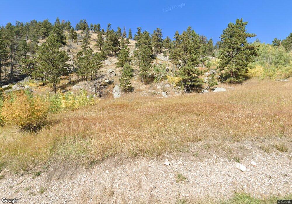
Cabin was burned in High Park fire - vacant land with septic, well and electricity. Beautiful views from this 15 ace site. Old foundation on site.

Last Listed By

Patricia Phillips

Group Mulberry Listed on: 06/15/2017

Group Mulberry

Property Details

Property Type

  • Land

Est. Annual Taxes

  • $307

Year Built

  • 1976

Lot Details

  • 15

Schools

  • Stove Prairie Elementary School
  • Cache La Poudre Middle School
  • Poudre High School

Additional Features

  • 15 Acre Lot
  • Mountain Views
  • Horses Allowed On Property
  • Septic System

Community Details

  • No Home Owners Association

Listing and Financial Details

  • Assessor Parcel Number R0255505

Property Details

Property Type

Land

Est. Annual Taxes

$307

Year Built

1976

Lot Details

0

Listing Details

  • Development Status: Approved Subdivided, Building Permit Ready
  • Property Sub Type: Unimproved Land
  • Prop. Type: Land
  • Horses: Yes
  • Lot Size Acres: 15
  • Subdivision Name: none
  • Special Features: None
  • Year Built: 1976

Interior Features

  • Possible Use: Single Family

Exterior Features

  • View: Mountain(s), Foothills View
  • Waterfront: No

Utilities

  • Electric: Electricity at Property, REA
  • Sewer: Septic
  • Water Source: Well

Condo/Co-op/Association

  • Senior Community: No
  • Association: No

Association/Amenities

  • IRESDS_HasAssociation2Reserve: No
  • IRESDS_HasAssociation2Fee: No
  • IRESDS_HasAssociationReserve: No
  • IRESDS_HasAssociationFee: No

Schools

  • Elementary School: Stove Prairie
  • HighSchool: Poudre
  • Junior High Dist: Poudre
  • Middle Or Junior School: Cache La Poudre

Lot Info

  • Zoning: Res
  • Current Use: Horses
  • Lot Size Sq Ft: 653400
  • Parcel #: R0255505
  • ResoLotSizeUnits: SquareFeet

Tax Info

  • Tax Year: 2016
  • Tax Annual Amount: 307

Multi Family

Ownership History

Date Name Owned For Owner Type

Purchase Details

Listed on
Jun 15, 2017
Closed on
Jun 22, 2017
Sold by
Conant Dale H and Conant Martha G
Bought by
Swenson Dennis Mark
Seller's Agent
Patricia Phillips
Group Mulberry
Buyer's Agent
Patricia Phillips
Group Mulberry
List Price
$92,500
Sold Price
$92,500
Total Days on Market
7
Current Estimated Value
$407,000

Home Financials for this Owner

Home Financials are based on the most recent Mortgage that was taken out on this home.
Estimated Appreciation
$314,500
Avg. Annual Appreciation
9.12%

Purchase Details

Closed on
Sep 6, 2000
Sold by
Benson Donald D Laurel J
Bought by
Conant Dale H and Conant Martha G

Home Financials for this Owner

Home Financials are based on the most recent Mortgage that was taken out on this home.
Original Mortgage
$67,500
Interest Rate
8.16%

Purchase Details

Closed on
Jun 1, 1979
Bought by
Benson Donald D and Benson Laurel J

Range of Values:

Collateral Analytics

Collateral Analytics Collateral Analytics AVMs (Automated Valuation Model) employ a number of statistical approaches combined with neighborhood-specific comparable selection guarantees the most up-to-date and precise valuations.

Not Available

Collateral Analytics does not have data for the current month. Please view the chart for historical values.

ICE

ICE Mortgage Technology ICE Mortgage Technology’s AVM (Automated Valuation Model) is a state-of-the-art online residential property valuation tool that provides a quick and accurate estimate of the value of almost any home in the U.S.

Not Available

ICE Mortgage Technology does not have data for the current month. Please view the chart for historical values.

First American

First American First American Data & Analytics’ next-generation AVM combines unrivaled data assets with a blended ensemble of valuation models to produce highly accurate, reliable valuations you can trust.

Not Available

First American does not have data for the current month. Please view the chart for historical values.

Quantarium

Quantarium Quantarium’s valuation service, repeatedly proven the industry’s most accurate and comprehensive, is supercharged with a self-learning and auto-tuning AI engine that continually becomes smarter and more accurate as it processes daily inputs from the industry’s leading RE data lake.

Not Available

Quantarium does not have data for the current month. Please view the chart for historical values.

Average Value
Not Available
List Price
Sold Price
Create a Home Valuation Report for This Property
The Home Valuation Report is an in-depth analysis detailing your home's value as well as a comparison with similar homes in the area

Similar Property in Bellvue, CO

  • 1081 Deer Horn Trail, Bellvue, CO 80512

    $425,000

    • Land
    • 12 Acres
    • $35,417 per Acre
    • 1081 Deer Horn Trail
    • Bellvue, CO

    125K in aggressive price reductions and highly motivated Seller. Wonderful mountain view property, 12 acre lot/home-building site with views of the White Pine mountains. Large meadow to view all the wildlife, resident elk/deer/moose, tested artisan (drinkable) water, propane, water and heat transfer lines ran out to two build sites (4' deep), active septic, dual inlets for R/V and home, twin 1000

    Mark Trippensee St Vrain Realty LLC

    Section Image

Home Values in the Area

Source: Public Records

Average Home Value in this Area


Source: Public Records

Purchase History

Date Buyer Sale Price Title Company
Swenson Dennis Mark $92,500 Heritage Title
Conant Dale H $142,500 --
Benson Donald D $47,000 --
Source: Public Records

Mortgage History

Date Status Borrower Loan Amount
Previous Owner Conant Dale H $67,500
Source: Public Records

Property History

Date Event Price Change Sq Ft Price
01/28/2019 01/28/19 Off Market $92,500 -- --
06/22/2017 06/22/17 Sold $92,500 0.0% $116 / Sq Ft
06/15/2017 06/15/17 For Sale $92,500 -- $116 / Sq Ft
Source: IRES MLS

Tax History Compared to Growth

Source: Public Records

Tax History

Year Tax Paid Tax Assessment Tax Assessment Total Assessment is a certain percentage of the fair market value that is determined by local assessors to be the total taxable value of land and additions on the property. Land Improvement
2025 $704 $11,966 $10,720 $1,246
2024 $665 $11,966 $10,720 $1,246
2022 $785 $9,327 $8,264 $1,063
2021 $785 $9,595 $8,501 $1,094
2020 $497 $6,013 $4,862 $1,151
2019 $499 $6,013 $4,862 $1,151
2018 $1,233 $15,370 $15,370 $0
2017 $1,228 $15,370 $15,370 $0
2016 $307 $3,821 $3,821 $0
2015 $305 $3,820 $3,820 $0
2014 $271 $3,380 $3,380 $0
Source: Public Records

Agents Affiliated with this Home

  • Section Image
See All Agents

Map

Source: IRES MLS

MLS Number: 824717

IRES MLS

APN: 18340-00-054