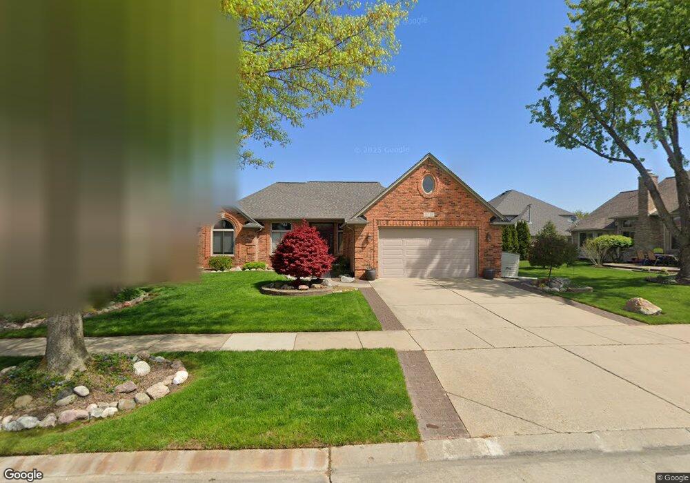
16735 Keith Dr Macomb, MI 48042
Estimated Value: $442,000 - $525,000
Studio
2
Baths
2,121
Sq Ft
$226/Sq Ft
Est. Value
About This Home
This home is located at 16735 Keith Dr, Macomb, MI 48042 and is currently estimated at $478,945, approximately $225 per square foot. 16735 Keith Dr is a home located in Macomb County with nearby schools including Richard J. Duncan Elementary, Shelby Junior High School, and Eisenhower High School.
Ownership History
Date
Name
Owned For
Owner Type
Purchase Details
Closed on
Jun 30, 2003
Sold by
Malburg Mark A and Malburg Heidi R
Bought by
Joseph Thomas R and Joseph Diane E
Current Estimated Value
Home Financials for this Owner
Home Financials are based on the most recent Mortgage that was taken out on this home.
Original Mortgage
$198,750
Interest Rate
6.44%
Mortgage Type
Purchase Money Mortgage
Purchase Details
Closed on
Dec 19, 1996
Sold by
Ests Huntington Wds
Bought by
Malburg M and Malburg H
Create a Home Valuation Report for This Property
The Home Valuation Report is an in-depth analysis detailing your home's value as well as a comparison with similar homes in the area
Home Values in the Area
Average Home Value in this Area
Purchase History
| Date | Buyer | Sale Price | Title Company |
|---|---|---|---|
| Joseph Thomas R | $265,000 | -- | |
| Malburg M | $45,500 | -- |
Source: Public Records
Mortgage History
| Date | Status | Borrower | Loan Amount |
|---|---|---|---|
| Previous Owner | Joseph Thomas R | $198,750 | |
| Closed | Joseph Thomas R | $53,000 |
Source: Public Records
Tax History
| Year | Tax Paid | Tax Assessment Tax Assessment Total Assessment is a certain percentage of the fair market value that is determined by local assessors to be the total taxable value of land and additions on the property. | Land | Improvement |
|---|---|---|---|---|
| 2025 | $2,515 | $219,100 | $0 | $0 |
| 2024 | $24 | $210,800 | $0 | $0 |
| 2023 | $2,318 | $182,500 | $0 | $0 |
| 2022 | $4,528 | $164,300 | $0 | $0 |
| 2021 | $3,452 | $158,400 | $0 | $0 |
| 2020 | $2,134 | $153,200 | $0 | $0 |
| 2019 | $4,257 | $143,500 | $0 | $0 |
| 2018 | $3,130 | $135,700 | $0 | $0 |
| 2017 | $3,090 | $130,920 | $32,500 | $98,420 |
| 2016 | $2,738 | $130,930 | $0 | $0 |
| 2015 | $2,754 | $125,800 | $0 | $0 |
| 2014 | $2,754 | $108,810 | $21,500 | $87,310 |
| 2013 | $1,775 | $108,810 | $0 | $0 |
Source: Public Records
Map
Nearby Homes
- 54806 Ashley Lauren Dr
- 16701 25 Mile Rd
- 16448 Trailway Dr
- 53650 Romeo Plank Rd
- 17827 Biscayne Dr
- 17824 Biscayne Dr
- 17646 Kite Dr
- 54680 Chickasaw Dr
- 55543 Hogan Dr
- 17389 Sarah Dr
- 17415 Sarah Dr
- 55853 Tiger Dr
- 55362 Trevino Dr
- 17317 Megan Dr
- 17317 Megan Dr Unit 45
- 55209 Nelson Dr
- 17332 Stallman Dr
- 17189 Stallman Dr
- 17524 Stallman Dr
- 17349 Stallman Dr
- 54409 Ashley Lauren Dr
- 54441 Ashley Lauren Dr
- 16758 Zachary Dr
- 16683 Keith Dr
- 16732 Zachary Dr
- 54473 Ashley Lauren Dr
- 16724 Keith Dr
- 16706 Zachary Dr
- 54345 Ashley Lauren Dr
- 16698 Keith Dr
- 54483 Ashley Lauren Dr
- 16657 Keith Dr
- 16672 Keith Dr
- 16680 Zachary Dr
- 54313 Ashley Lauren Dr
- 54422 Ashley Lauren Dr
- 54390 Ashley Lauren Dr
- 54454 Ashley Lauren Dr
- 16646 Keith Dr
- 16631 Keith Dr
Your Personal Tour Guide
Ask me questions while you tour the home.